
| LINDEN LINDEN NJ |
| |
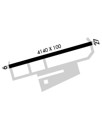
| Lat: N 4037.0 Long: W 07414.7 Elev: 22 Var: +13 Longest Runway: 4140 | ||
| Clr Del: 127.25 AWOS: 124.02 CTAF: 123.0 | ||
| ||||||
| ||||||
|
| Rwy | Rwy | |||||||
| 4140x100 | 3678' | 4140x100 | 3599' | |||||
| Runway ID | Single Wheel | Double Wheel | Double Tandem Wheel | Dual Double Wheel |
| 09/27 | 31,500 | 42,000 | N/A | N/A |
| These numbers are Advisory and are not limits. The Airport Manager should have more accurate Weight Limits | ||||
 Airport Diagram might not be current. | |
| Facility Name: | LINDEN |
| City Name: | LINDEN |
| County: | UNION |
| State abbrev: | NJ |
| State Name: | NEW JERSEY |
| Ownership: | PUBLICLY OWNED |
| Use: | OPEN TO THE PUBLIC |
| Owner's Name: | CITY OF LINDEN |
| Address: | 1101 WEST EDGAR RD |
| LINDEN, NJ 07036 | |
| Owner's Phone: | 908-862-5557 |
| Manager's Name: | PAUL DUDLEY |
| Address: | 1101 WEST EDGAR RD |
| LINDEN, NJ 07036 | |
| Phone: | 908-862-5557 |
| FAA Region: | EASTERN |
| FAA Field Office: | HAR |
| Date | Sunrise | Sunset |
|---|---|---|
| 09/24/21 Friday | 6:46 | 18:51 |
| 09/25/21 Saturday | 6:47 | 18:50 |
| 09/26/21 Sunday | 6:48 | 18:48 |
| 09/27/21 Monday | 6:49 | 18:46 |
| 09/28/21 Tuesday | 6:50 | 18:44 |
| 09/29/21 Wednesday | 6:51 | 18:43 |
| 09/30/21 Thursday | 6:52 | 18:41 |
| 10/01/21 Friday | 6:53 | 18:40 |
| 10/02/21 Saturday | 6:54 | 18:38 |
| 10/03/21 Sunday | 6:55 | 18:36 |
| 10/04/21 Monday | 6:56 | 18:35 |
| 10/05/21 Tuesday | 6:57 | 18:33 |
| 10/06/21 Wednesday | 6:58 | 18:31 |
| 10/07/21 Thursday | 6:59 | 18:30 |
| Airport Attendance Schedule | OCT-APR 7 Days A Week 0830-1800, MAY-SEP 7 Days A Week 0700-2030 |
| Airport Status | OPERATIONAL (This Status can change at any time - please check NOTAMS) |
| Airport Lighting Schedule | ACTVT MIRL RY 09/27; VASI RYS 09 & 27; AND REILS RYS 09 & 27- CTAF. |
| Airport Storage Available | Tie Downs, Hanger |
| Extra Services Available | Charter, Flight Instruction, Aircraft Rental, Aircraft Sales |
| Wind Indicator | YES - (lighted) |
| Control Tower | NO |
| CTAF Frequency | 123.000 |
| Unicom Frequency | 123.000 |
| Rotating Beacon Color | CLEAR-GREEN (Light Land Airport) |
| Segmented Circle | YES |
| Landing Fee | YES |
| Airport Inspected | STATE - performed by STATE AERONAUTICAL PERSONNEL |
| Inspection Date | 07/30/2020 |
| Type of Fuel Available | Grade 100LL, JET A (freeze point -40C) |
| Airframe Repair Service | MINOR |
| Power Plant Repair Service | MINOR |
| Latitude | N4037.0 |
| Longitude | W07414.7 (ESTIMATED) |
| Arpt Elevation | 22ft (SURVEYED) |
| Magnetic Variation | 13W |
| 1 miles SE | of LINDEN |
| Traffic Pattern Altitude | |
| Sectional Chart | NEW YORK |
| Operations (Reported) | Yearly | Avg. Daily |
|---|---|---|
| General Aviation Transient | 21604 | 59 |
| General Aviation Local | 34360 | 94 |
| Air Taxi | 0 | 0 |
| Commerical | 0 | 0 |
| Commuter | 0 | 0 |
| Military | 467 | 1 |
| Aircraft based on Field | |
|---|---|
| General Aviation Singles | 23 |
| General Aviation Multi | 1 |
| Jet Aircraft | 0 |
| General Aviation Helicopters | 3 |
| Military Aircraft | 0 |
| Gliders | 0 |
| Ultralights | 0 |
| FSS on field | NO |
| FSS tie-in | MILLVILLE |
| FSS Phone | 1-800-WX-BRIEF |
| Who issues Notams | MIV |
| Notam D service at airport | YES |
| ARTCC Name | NEW YORK |
| Airport Certification | |
| Aircraft Rescue & Firefighting Index | None |
| Airport of Entry | No |
| Custom Landing Rights | No |
| Joint Civil/Military | No |
| Military Landing rights | YES |
| NATIONAL PLAN OF INTEGRATED AIRPORT SYSTEMS (NPIAS) |
| GRANT AGREEMENTS UNDER FAAP/ADAP/AIP |
| ASSURANCES PURSUANT TO TITLE VI, CIVIL RIGHTS ACT OF 1964 |
| TPA 800 FT MSL; RY 9 ENTER TFC PAT UPWIND - ENTRIES OTR RYS STD. |
| MAIN NORTH TWY CLSD INDEFLY. |
| DEER & BIRDS ON & INVOF APRT. |
| DEPG RY 27 DEP STRAIGHT OUT TO 800 FT. |
| NOISE ABATEMENT PROCEDURES IN EFFECT. |
| TOUCH & GO LANDINGS FOR BASE ASSIGNED ACFT; ALL OTHERS CTC AMGR (908) 862-8800 FOR PPR. |
| RY 09/27 RWY SHOULDER MARKINGS NSTD. |
| MAIN NORTH TWY CLSD INDEFLY. |
Airport Communications & Frequencies:
| |||||||||||||||||||||
| Runway: 09 | Runway: 27 | ||
| Mag heading: | 89° | Mag heading: | 269° |
| Rwy Slope: | -.10% Down | Rwy Slope: | .10% Up |
| Approach: | Approach: | ||
| Pattern: | Left Traffic | Pattern: | Left Traffic |
| Markings: | NONPRECISION INSTRUMENT | Markings: | BASIC |
| Marking Condition: | FAIR | Marking Condition: | FAIR |
| Arresting Dev: | Arresting Dev: | ||
| Lat & Long: | N4037.0 W07415.1 | Lat. & Long.: | N4037.1 W07414.2 |
| Elev: | 21.9 ft. MSL | Elev: | 17.9 ft. MSL |
| TCH: | 60 ft. AGL | TCH: | 37 ft. AGL |
| Visual Glide Path: | 3.80 degrees | Visual Glide Path: | 3.25 degrees |
| Displaced Threshold: | 462 feet | Displaced Threshold: | 541 feet |
| Touchdown Zone: | YES | Touchdown Zone: | YES |
| Touchdown Elev.: | 21.8 feet | Touchdown Elev.: | 21.7 feet |
| Visual Glide Slope: | 2-Box VASI on RIGHT side of Runway; VASI IS BAFFLED TO CUT OFF THE LGT BEAM AT 6 DEGS EACH SIDE OF RY CNTRLN EXTDD; TOTAL USBL WIDTH IS 12 DEGS. | Visual Glide Slope: | 2-Box VASI on LEFT side of Runway |
| RVR Equipment: | RVR Equipment: | ||
| RVV Equipment: | NO | RVV Equipment: | NO |
| Approach Lights: | Approach Lights: | ||
| REIL: | YES | REIL: | YES |
| Centerline Lights: | NO | Centerline Lights: | NO |
| Touchdown lights: | NO | Touchdown lights: | NO |
| Runway Category: | Runway with a Visual Approach | Runway Category: | Runway with a Visual Approach |
| Declared Distances: | Declared Distances: | ||
| Obstructions: | POLE | Obstructions: | ANT |
| Marked: | NOT Marked/Lighted | Marked: | NOT Marked/Lighted |
| Clearance slope: | 4:1; APCH RATIO 25:1 TO DSPLCD THLD BASED ON 32 FT POLE 812 FT FM DSPLCD THLD. | Clearance slope: | 7:1; APCH RATIO23:1 TO DSPLCD THLD BASED ON 47 FT ANTENNA 1097 FT FM DSPLCD THLD. |
| Obstruction height: | 32 feet AGL | Obstruction height: | 47 feet AGL |
| Dist. from runway: | 352 feet | Dist. from runway: | 554 feet |
| Centerline offset: | 30 right of centerline | Centerline offset: | 100 feet right of centerline |
| Comments: | Comments: |
Thanks for using FltPlan.com
all rights reserved © 1999-2021 by Flight Plan LLC
