
| CHARLESTON EXECUTIVE CHARLESTON SC |
| |
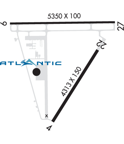
| Lat: N 3242.1 Long: W 08000.2 Elev: 19 Var: +05 Longest Runway: 5350 | ||
| Clr Del: 119.85 AWOS: 123.77 CTAF: 122.8 | ||
| ||||||||||||||||||||||||||||||||||||||||||||||||||||||||||||||||||||
| ||||||||||||||||||||||||||||||||||||||||||||||||||||||||||||||||||||
| ||||||||||||||||||||||||||||||||||||||||||||||||||||||||||||||||||||
| Rwy | Rwy | |||||||
| 4313x150 | 4313' | 4313x150 | 4313' | |||||
| 5350x100 | 5350' | 110.70 - 091° | 5350x100 | 5000' | ||||
| Runway ID | Single Wheel | Double Wheel | Double Tandem Wheel | Dual Double Wheel |
| 04/22 | 45,000 | 56,000 | N/A | N/A |
| 09/27 | 60,000 | 100,000 | N/A | N/A |
| These numbers are Advisory and are not limits. The Airport Manager should have more accurate Weight Limits | ||||
 Airport Diagram might not be current. | |
| Facility Name: | CHARLESTON EXEC |
| City Name: | CHARLESTON |
| County: | CHARLESTON |
| State abbrev: | SC |
| State Name: | SOUTH CAROLINA |
| Ownership: | PUBLICLY OWNED |
| Use: | OPEN TO THE PUBLIC |
| Owner's Name: | CHARLESTON CO AVN AUTHORITY |
| Address: | 5500 INTL BLVD, # 101 |
| CHARLESTON, SC 29418-6911 | |
| Owner's Phone: | 843-767-7000 |
| Manager's Name: | ELLIOTT SUMMEY |
| Address: | 5500 INTERNATIONAL BLVD, #101 |
| CHARLESTON, SC 29418 | |
| Phone: | 843-767-7000 |
| FAA Region: | SOUTHERN |
| FAA Field Office: | ATL |

| Date | Sunrise | Sunset |
|---|---|---|
| 09/24/21 Friday | 7:09 | 19:14 |
| 09/25/21 Saturday | 7:10 | 19:13 |
| 09/26/21 Sunday | 7:11 | 19:12 |
| 09/27/21 Monday | 7:11 | 19:10 |
| 09/28/21 Tuesday | 7:12 | 19:09 |
| 09/29/21 Wednesday | 7:13 | 19:08 |
| 09/30/21 Thursday | 7:13 | 19:06 |
| 10/01/21 Friday | 7:14 | 19:05 |
| 10/02/21 Saturday | 7:15 | 19:04 |
| 10/03/21 Sunday | 7:15 | 19:02 |
| 10/04/21 Monday | 7:16 | 19:01 |
| 10/05/21 Tuesday | 7:17 | 19:00 |
| 10/06/21 Wednesday | 7:17 | 18:58 |
| 10/07/21 Thursday | 7:18 | 18:57 |
| Airport Attendance Schedule | 7 Days A Week 0600-2200 |
| Airport Status | OPERATIONAL (This Status can change at any time - please check NOTAMS) |
| Airport Lighting Schedule | SR-SS, TO ACTVT AND INCR INTST REIL RWY 09 & 27; HIRL RWY 09/27; MIRL RWY 04/22 - CTAF. SR-SS, PAPI RWY 09 & 27 OPR CONSLY. SS-SR, REIL RWY 09 & 27; PAPI RWY 09 & 27; HIRL RWY 09/27 OPR CONSLY, TO INCR INTST - CTAF. SS-SR, TO ACTVT MIRL RWY 04/22 - CTAF. |
| Airport Storage Available | Tie Downs, Hanger |
| Extra Services Available | Flight Instruction, Aircraft Rental |
| Wind Indicator | YES - (lighted) |
| Control Tower | NO |
| CTAF Frequency | 122.800 |
| Unicom Frequency | 122.800 |
| Rotating Beacon Color | CLEAR-GREEN (Light Land Airport) |
| Segmented Circle | YES |
| Landing Fee | NO |
| Airport Inspected | STATE - performed by STATE AERONAUTICAL PERSONNEL |
| Inspection Date | 12/13/2019 |
| Type of Fuel Available | Grade 100LL, JET A (freeze point -40C) |
| Airframe Repair Service | MINOR |
| Power Plant Repair Service | MINOR |
| Latitude | N3242.1 |
| Longitude | W08000.2 (ESTIMATED) |
| Arpt Elevation | 18ft (SURVEYED) |
| Magnetic Variation | 05W |
| 6 miles SW | of CHARLESTON |
| Traffic Pattern Altitude | |
| Sectional Chart | CHARLOTTE |
| Operations (Reported) | Yearly | Avg. Daily |
|---|---|---|
| General Aviation Transient | 15870 | 43 |
| General Aviation Local | 10108 | 28 |
| Air Taxi | 2022 | 6 |
| Commerical | 0 | 0 |
| Commuter | 0 | 0 |
| Military | 3000 | 8 |
| Aircraft based on Field | |
|---|---|
| General Aviation Singles | 35 |
| General Aviation Multi | 2 |
| Jet Aircraft | 2 |
| General Aviation Helicopters | 0 |
| Military Aircraft | 0 |
| Gliders | 0 |
| Ultralights | 0 |
| FSS on field | NO |
| FSS tie-in | ANDERSON |
| FSS Phone | 1-800-WX-BRIEF |
| Who issues Notams | AND |
| Notam D service at airport | YES |
| ARTCC Name | JACKSONVILLE |
| Airport Certification | |
| Aircraft Rescue & Firefighting Index | None |
| Airport of Entry | No |
| Custom Landing Rights | No |
| Joint Civil/Military | No |
| Military Landing rights | YES |
| NATIONAL PLAN OF INTEGRATED AIRPORT SYSTEMS (NPIAS) |
| GRANT AGREEMENTS UNDER FAAP/ADAP/AIP |
| SURPLUS PROPERTY AGREEMENT UNDER PUBLIC LAW 289 |
| SURPLUS PROPERTY AGREEMENT UNDER REGULATION 16-WAA |
| ASSURANCES PURSUANT TO TITLE VI, CIVIL RIGHTS ACT OF 1964 |
| DEER & BIRDS ON & INVOF ARPT. |
| FOR CD CTC CHARLESTON APCH AT 843-414-2832. |
Airport Communications & Frequencies:
| ||||||||||||||||
| Runway: 04 | Runway: 22 | ||
| Mag heading: | 37° | Mag heading: | 217° |
| Rwy Slope: | .03% Up | Rwy Slope: | -.03% Down |
| Approach: | Approach: | ||
| Pattern: | Left Traffic | Pattern: | Left Traffic |
| Markings: | NONPRECISION INSTRUMENT | Markings: | BASIC |
| Marking Condition: | GOOD | Marking Condition: | GOOD |
| Arresting Dev: | Arresting Dev: | ||
| Lat & Long: | N3241.5 W08000.3 | Lat. & Long.: | N3242.1 W07959.9 |
| Elev: | 9.8 ft. MSL | Elev: | 11.1 ft. MSL |
| TCH: | TCH: | ||
| Visual Glide Path: | Visual Glide Path: | ||
| Displaced Threshold: | No | Displaced Threshold: | No |
| Touchdown Zone: | YES | Touchdown Zone: | YES |
| Touchdown Elev.: | 13.4 feet | Touchdown Elev.: | 13.4 feet |
| Visual Glide Slope: | Visual Glide Slope: | ||
| RVR Equipment: | RVR Equipment: | ||
| RVV Equipment: | NO | RVV Equipment: | NO |
| Approach Lights: | Approach Lights: | ||
| REIL: | NO | REIL: | NO |
| Centerline Lights: | NO | Centerline Lights: | NO |
| Touchdown lights: | NO | Touchdown lights: | NO |
| Runway Category: | Runway with a Non-precision Approach having visibility minimums greater than 3/4 mile | Runway Category: | Runway with a Visual Approach |
| Declared Distances: | Declared Distances: | ||
| Obstructions: | TREE | Obstructions: | |
| Marked: | NOT Marked/Lighted | Marked: | |
| Clearance slope: | 25:1 | Clearance slope: | 20:1 |
| Obstruction height: | 75 feet AGL | Obstruction height: | |
| Dist. from runway: | 2160 feet | Dist. from runway: | |
| Centerline offset: | 227 right of centerline | Centerline offset: | |
| Comments: | Comments: |
| Runway: 09 | Runway: 27 | ||
| Mag heading: | 94° | Mag heading: | 274° |
| Rwy Slope: | -.14% Down | Rwy Slope: | .14% Up |
| Approach: | ILS/DME | Approach: | |
| Pattern: | Left Traffic | Pattern: | Left Traffic |
| Markings: | PRECISION INSTRUMENT | Markings: | NONPRECISION INSTRUMENT |
| Marking Condition: | GOOD | Marking Condition: | GOOD |
| Arresting Dev: | Arresting Dev: | ||
| Lat & Long: | N3242.3 W08000.8 | Lat. & Long.: | N3242.3 W07959.7 |
| Elev: | 18.6 ft. MSL | Elev: | 11.1 ft. MSL |
| TCH: | 50 ft. AGL | TCH: | 44 ft. AGL |
| Visual Glide Path: | 3.00 degrees | Visual Glide Path: | 3.00 degrees |
| Displaced Threshold: | No | Displaced Threshold: | 350 feet |
| Touchdown Zone: | YES | Touchdown Zone: | YES |
| Touchdown Elev.: | 18.6 feet | Touchdown Elev.: | 15.4 feet |
| Visual Glide Slope: | 4-Light PAPI on LEFT side of Runway | Visual Glide Slope: | 4-Light PAPI on RIGHT side of Runway |
| RVR Equipment: | RVR Equipment: | ||
| RVV Equipment: | NO | RVV Equipment: | NO |
| Approach Lights: | Approach Lights: | ||
| REIL: | YES | REIL: | YES |
| Centerline Lights: | NO | Centerline Lights: | NO |
| Touchdown lights: | NO | Touchdown lights: | NO |
| Runway Category: | Precision Instrument Runway | Runway Category: | Runway with a Non-precision Approach having visibility minimums greater than 3/4 mile |
| Declared Distances: | Declared Distances: | ||
| Obstructions: | TREE | Obstructions: | BRUSH |
| Marked: | NOT Marked/Lighted | Marked: | NOT Marked/Lighted |
| Clearance slope: | 35:1 | Clearance slope: | 14:1; APPROACH SLOPE TO DISPLACED THLD. IS 50:1. |
| Obstruction height: | 112 feet AGL | Obstruction height: | 16 feet AGL |
| Dist. from runway: | 4162 feet | Dist. from runway: | 438 feet |
| Centerline offset: | 517 right of centerline | Centerline offset: | 250 feet right of centerline |
| Comments: | Comments: |
Thanks for using FltPlan.com
all rights reserved © 1999-2021 by Flight Plan LLC


