
| JOHN F KENNEDY INTL NEW YORK NY |
| |
| Lat: N 4038.4 Long: W 07346.7 Elev: 13 Var: +13 Longest Runway: 14511 | ||
| Clr Del: 135.05 Dept. ATIS: 128.72 Arr. ATIS: 128.72/117.7 Ground: 121.65/121.9 Tower: 119.1/123.9 | ||
| ||||||||||||||||||||||||||||||||||||||||||||
| ||||||||||||||||||||||||||||||||||||||||||||
| ||||||||||||||||||||||||||||||||||||||||||||
| ||||||||||||||||||||||||||||||||||||||||||||
| ||||||||||||||||||||||||||||||||||||||||||||
| Rwy | Rwy | |||||||
| 12079x200 | 11619' | 110.90 - 043° | 12079x200 | 8655' | 109.50 - 221° | |||
| 8400x200 | 8400' | 109.50 - 043° | 8400x200 | 8400' | 110.90 - 223° | |||
| 10000x200 | 9093' | 111.50 - 133° | 10000x200 | 8973' | 111.50 - 313° | |||
| 14511x200 | 12467' | 14511x200 | 11247' | 111.35 - 313° | ||||
| Runway ID | Single Wheel | Double Wheel | Double Tandem Wheel | Dual Double Wheel |
| 04L/22R | N/A | 210,000 | 550,000 | 1,100,000 |
| 04R/22L | N/A | 210,000 | 550,000 | 1,100,000 |
| 13L/31R | N/A | 210,000 | 550,000 | 1,100,000 |
| 13R/31L | N/A | 210,000 | 550,000 | 1,100,000 |
| These numbers are Advisory and are not limits. The Airport Manager should have more accurate Weight Limits | ||||
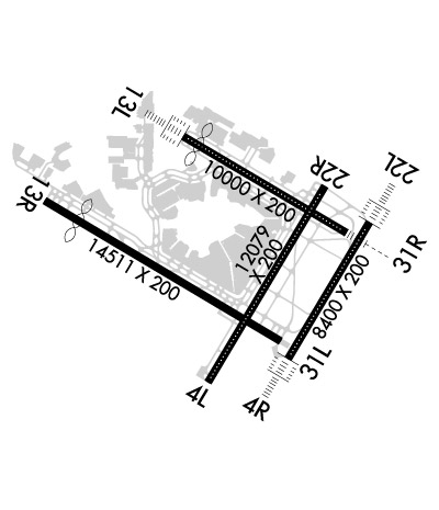 Airport Diagram might not be current. | |
| Facility Name: | JOHN F KENNEDY INTL |
| City Name: | NEW YORK |
| County: | QUEENS |
| State abbrev: | NY |
| State Name: | NEW YORK |
| Ownership: | PUBLICLY OWNED |
| Use: | OPEN TO THE PUBLIC |
| Owner's Name: | PORT AUTHORITY OF NY AND NJ; LEASEE: PROPERTY OWNED BY CITY OF NEW YORK, BUREAU OF FERRY AND GENERAL AVIATION. |
| Address: | 4 WORLD TRADE CENTER, 150 GREENWICH ST 18TH FLOO |
| NEW YORK, NY 10006 | |
| Owner's Phone: | 212-435-3640 |
| Manager's Name: | TERESA RIZZUTO |
| Address: | BLDG 14 |
| JAMAICA, NY 11430 | |
| Phone: | (718) 244-3501 |
| FAA Region: | EASTERN |
| FAA Field Office: | NYC |
| Date | Sunrise | Sunset |
|---|---|---|
| 06/26/26 Friday | 5:26 | 20:30 |
| 06/27/26 Saturday | 5:26 | 20:30 |
| 06/28/26 Sunday | 5:26 | 20:30 |
| 06/29/26 Monday | 5:27 | 20:30 |
| 06/30/26 Tuesday | 5:27 | 20:30 |
| 07/01/26 Wednesday | 5:28 | 20:30 |
| 07/02/26 Thursday | 5:28 | 20:30 |
| 07/03/26 Friday | 5:29 | 20:30 |
| 07/04/26 Saturday | 5:29 | 20:29 |
| 07/05/26 Sunday | 5:30 | 20:29 |
| 07/06/26 Monday | 5:30 | 20:29 |
| 07/07/26 Tuesday | 5:31 | 20:29 |
| 07/08/26 Wednesday | 5:32 | 20:28 |
| 07/09/26 Thursday | 5:32 | 20:28 |
| Airport Attendance Schedule | CONTINUOUS |
| Airport Status | OPERATIONAL (This Status can change at any time - please check NOTAMS) |
| Airport Lighting Schedule | |
| Airport Storage Available | Hanger |
| Extra Services Available | Air Freight, Cargo Handling |
| Wind Indicator | YES - (lighted) |
| Control Tower | YES |
| CTAF Frequency | |
| Unicom Frequency | 122.950 |
| Rotating Beacon Color | WG |
| Segmented Circle | NO |
| Landing Fee | YES |
| Airport Inspected | FEDERAL - performed by FAA AIRPORTS FIELD PERSONNEL |
| Inspection Date | 04/20/2026 |
| Type of Fuel Available | Grade 100LL, JET A (freeze point -40C); -10GENERAL AVIATION: NON-BASED CHARTER & NON-BASED COML ACFT OPERATORS MUST MAKE ARRANGEMENTS FOR FUEL PRIOR TO ARRIVAL; CALL 347-566-6620 OR UNICOM 122.95. |
| Airframe Repair Service | MAJOR |
| Power Plant Repair Service | MAJOR |
| Latitude | N4038.4 |
| Longitude | W07346.7 (ESTIMATED) |
| Arpt Elevation | 13ft (SURVEYED) |
| Magnetic Variation | 13W |
| 13 miles SE | of NEW YORK |
| Traffic Pattern Altitude | |
| Sectional Chart | NEW YORK |
| Operations (Reported) | Yearly | Avg. Daily |
|---|---|---|
| General Aviation Transient | 0 | 0 |
| General Aviation Local | 0 | 0 |
| Air Taxi | 0 | 0 |
| Commerical | 0 | 0 |
| Commuter | 0 | 0 |
| Military | 0 | 0 |
| Aircraft based on Field | |
|---|---|
| General Aviation Singles | 0 |
| General Aviation Multi | 0 |
| Jet Aircraft | 0 |
| General Aviation Helicopters | 0 |
| Military Aircraft | 0 |
| Gliders | 0 |
| Ultralights | 0 |
| FSS on field | NO |
| FSS tie-in | NEW YORK |
| FSS Phone | 1-800-WX-BRIEF |
| Who issues Notams | JFK |
| Notam D service at airport | YES |
| ARTCC Name | NEW YORK |
| Airport Certification | AIRPORT RECEIVING SCHEDULED AIR CARRIER SERVICE FROM CARRIERS CERTIFICATED BY THE CIVIL AERONAUTICS BOARD |
| Aircraft Rescue & Firefighting Index | AIRPORT HAS A CERTIFICATE UNDER CFR PART 139 |
| Airport of Entry | No |
| Custom Landing Rights | YES |
| Joint Civil/Military | No |
| Military Landing rights | YES |
| NATIONAL PLAN OF INTEGRATED AIRPORT SYSTEMS (NPIAS) |
| GRANT AGREEMENTS UNDER FAAP/ADAP/AIP |
| CONVEYANCE UNDER SCETION 16, FEDERAL AIRPORT ACT OF 1946 OR SECTION 23, AIRPORT AND AIRWAY DEVELOPMENT ACT OF 1970 |
| ASSURANCES PURSUANT TO TITLE VI, CIVIL RIGHTS ACT OF 1964 |
| AGREEMENT UNDER DLAND OR DCLA HAS EXPIRED. |
| FLOCKS OF BIRDS ON & INVOF ARPT. |
| CONVERGING OPNS ON RYS 13R AND 22L CONDUCTED VIA ARRIVAL DISTANCE WINDOW. |
| METERING PROCEDURES IN EFFECT- CONTACT RAMP CONTROL PRIOR TO PUSHBACK 1200Z-1500Z DAILY/1900Z-0300Z DAILY. |
| ACFT OPS & TWY RESTRICTIONS EXIST FOR A380, B747-800, B777-300ER, A340-600 AND A350-1000. PLEASE CTC JFK ARPT OPS FOR MORE INFO. |
| GAT HELIPAD NON-STANDARD MARKINGS & LIGHTING. |
| RLLS RY 13L USES 1000 FT LGT STN OF THE ALS ONLY WITH CRI VOR APCHS & IS ANGLED TOWARD AQUEDUCT; ALSO 5 SFL FM 1200-2000 FT & A 5 SFL GROUPING APROXLY 1 MI FM RY +1 ADJ FORMING APCH. APCH GATE ANGLED 35 DEGS S OF RY 13L CNTRLN DESIGNED TO PRVD EARLIER IDENT OF RY ENVI. |
| RY 13R HAS TWO (2) PAPI - P4L SYSTEMS. ( RY 13R) OFFSET PAPI SUPPORTS VOR OR GPS RWY 13R & PARKWAY VISUAL RY 13R. |
| TWY 'A' BTN TWY 'NA' & TWY 'NB' ARCFT SPEED RESTRICTION OF 17KTS/20MPH MAXIMUM FOR A380, B747-800, B747-400, B777-300ER, B777-200, A340, A330, B787, AND A350 |
| RY 31R HOLDING POSITION MARKINGS AT RY 4L/22R 'SE' SIDE OBSC. |
| RY 13L HOLDING POSITION MARKINGS AT RY 4L/22R 'NW' SIDE OBSC. |
| UFN TWY 'D' BTN TWY 'C' AND HANGAR 7 CLOSED. |
| OBST BLDG LGT OTS 6.3 NM ESE JFK 222 FT MSL (220 FT AGL). |
| NON-STANDARD ENGINEERED MATERIALS ARRESTING SYSTEM (EMAS) 393 FT IN LENGTH BY 226 FT IN WIDTH LCTD AT THE DER 4R. |
| FOR NOISE ABATEMENT RSTRNS CALL 1-800-225-1071. |
| NON-STANDARD ENGINEERED MATERIALS ARRESTING SYSTEM (EMAS) 405 FT IN LENGTH BY 226 FT IN WIDTH LCTD AT THE DER 22L. |
| RWY STATUS LGTS IN OPS. |
| CONTINUOUS TAXIWAY MAINTENANCE ACTIVITIES AT NUMEROUS LOCATIONS |
| HIGH VOLUME OF LOW LEVEL VFR TRAFFIC, 500 FT AND BLO, ALONG SHORELINE SOUTH OF JFK. |
| TWY NB CLSD TO SB TURNS AT TWY A. |
| ACFT ARE NOT PMTD TO STOP ON EITHER TWY A OR B BRIDGES. |
| PERIODIC FIRE DEPT TRNG ADJACENT APCH END OF RWYS 22L & 22R. |
| RWY 31R 1000 FT DIST REMAINING SIGN MISG. |
| NON-STD MARKINGS IN GA APN, CTC FBO ON UNICOM OR 347-566-6620 FOR WING WALKERS. |
| OBST PARKED ACFT (ASN 2020-AEA-1302-NRA) 403933 N0734749W (1.4NM NW JFK) 74 (64FT AGL) U/S 1200-0100 DLY. |
| A380 AND B747-800 ACFT TAX SPD RESTRICTED TO MAX 17KTS/20MPH ON ALL TWYS. |
| TWY Z BTN RWY 04L & 22R AND TWY Y CLSD UFN. |
| TWY VA CLSD BTWN TRML 7 APRON AND TWY A. |
| TWY K RUNUP PAD CLSD TO ACFT WINGSPAN MORE THAN 140 FT. |
| PARA-SAIL & BANNER TOWING OPNS 1000 FT & BLO IN UPPER & LOWER NEW YORK BAYS INCLUDING ROCKAWAY INLET INDEFLY. |
| SPECIAL AIR TFC RULES-PART 93 HIGH DENSITY ARPT. PROR RESERVATION REQUIRED. SEE AERONAUTICAL INFORMATION MANUAL. |
| RWY 13R CAUTION RWY 13R CAN BE CONFUSED WITH RWY 13L. |
| RWY 04L/ 22RPCR VALUE: 1260/R/B/W/T |
| RWY 04R/ 22LPCR VALUE: 1260/F/B/X/T |
| RWY 13L/ 31RPCR VALUE: 1260/R/B/W/T |
| RWY 13R/ 31LPCR VALUE: 1260/R/B/W/T |
Airport Communications & Frequencies:
| |||||||||||||||||||||||||||||||||||||||||||||||||||||||||||||||||||||||||||||||||
| Runway: 04L | Runway: 22R | ||
| Mag heading: | 44° | Mag heading: | 224° |
| Rwy Slope: | .00% Up | Rwy Slope: | .00% Down |
| Approach: | ILS/DME | Approach: | ILS/DME |
| Pattern: | Left Traffic | Pattern: | Left Traffic |
| Markings: | PRECISION INSTRUMENT | Markings: | PRECISION INSTRUMENT |
| Marking Condition: | GOOD | Marking Condition: | GOOD |
| Arresting Dev: | Arresting Dev: | ||
| Lat & Long: | N4037.3 W07347.1 | Lat. & Long.: | N4039.0 W07345.8 |
| Elev: | 11.9 ft. MSL | Elev: | 12.5 ft. MSL |
| TCH: | 75 ft. AGL | TCH: | 77 ft. AGL |
| Visual Glide Path: | 3.00 degrees | Visual Glide Path: | 3.00 degrees |
| Displaced Threshold: | 460 feet | Displaced Threshold: | 3424 feet |
| Touchdown Zone: | YES | Touchdown Zone: | YES |
| Touchdown Elev.: | 12.7 feet | Touchdown Elev.: | 12.7 feet |
| Visual Glide Slope: | 4-Light PAPI on LEFT side of Runway | Visual Glide Slope: | 4-Light PAPI on LEFT side of Runway; RWY 22R PAPI UNUSBL BYD 8 DEG RIGHT OF CNTRLN. |
| RVR Equipment: | TOUCHDOWN-ROLLOUT | RVR Equipment: | TOUCHDOWN-ROLLOUT |
| RVV Equipment: | NO | RVV Equipment: | NO |
| Approach Lights: | Approach Lights: | ||
| REIL: | NO | REIL: | NO |
| Centerline Lights: | YES | Centerline Lights: | YES |
| Touchdown lights: | YES | Touchdown lights: | NO |
| Runway Category: | Precision Instrument Runway | Runway Category: | Precision Instrument Runway |
| Declared Distances: | TORA:11351' TODA:11351' ASDA:11470' LDA:11010' | Declared Distances: | TORA:12079' TODA:12079' ASDA:11219' LDA:7795' |
| Obstructions: | Obstructions: | TREE | |
| Marked: | Marked: | NOT Marked/Lighted | |
| Clearance slope: | 50:1 | Clearance slope: | 27:1; APCH RATIO 50:1 TO DTHR. |
| Obstruction height: | Obstruction height: | 70 feet AGL | |
| Dist. from runway: | Dist. from runway: | 2145 feet | |
| Centerline offset: | Centerline offset: | 37 feet left of centerline | |
| Comments: | Comments: |
| Runway: 04R | Runway: 22L | ||
| Mag heading: | 44° | Mag heading: | 224° |
| Rwy Slope: | .00% | Rwy Slope: | .00% |
| Approach: | ILS/DME | Approach: | ILS/DME |
| Pattern: | Left Traffic | Pattern: | Left Traffic |
| Markings: | PRECISION INSTRUMENT | Markings: | PRECISION INSTRUMENT |
| Marking Condition: | GOOD | Marking Condition: | GOOD |
| Arresting Dev: | EMAS; EMAS NON-STD ARRESTING GEAR/SYSTEM: ENGINEERED MATERIALS ARRESTING SYSTEM (EMAS) 393 FT IN LENGTH BY 226 FT WIDTH LCTD AT DER 4R. | Arresting Dev: | EMAS; EMAS NON-STD ARRESTING GEAR/SYTEM: ENGINEERED MATERIALS ARRESTING SYSTEM (EMAS) 405 FT IN LENGTH BY 226 FT WIDTH LCTD AT DER 22L. |
| Lat & Long: | N4037.5 W07346.2 | Lat. & Long.: | N4038.7 W07345.3 |
| Elev: | 11.9 ft. MSL | Elev: | 11.9 ft. MSL |
| TCH: | 69 ft. AGL | TCH: | 66 ft. AGL |
| Visual Glide Path: | 3.00 degrees | Visual Glide Path: | 3.00 degrees |
| Displaced Threshold: | No | Displaced Threshold: | No |
| Touchdown Zone: | YES | Touchdown Zone: | YES |
| Touchdown Elev.: | 12.0 feet | Touchdown Elev.: | 12.0 feet |
| Visual Glide Slope: | 4-Light PAPI on LEFT side of Runway | Visual Glide Slope: | 4-Light PAPI on LEFT side of Runway; RWY 22L PAPI HORIZONTAL OFFSET 4 DEG TO LEFT. |
| RVR Equipment: | TOUCHDOWN-MIDFIELD-ROLLOUT | RVR Equipment: | TOUCHDOWN-MIDFIELD-ROLLOUT |
| RVV Equipment: | NO | RVV Equipment: | NO |
| Approach Lights: | ALSF2 - standard 2,400 foot high intensity approach lighting system with sequenced flashers, Category II or III | Approach Lights: | ALSF2 - standard 2,400 foot high intensity approach lighting system with sequenced flashers, Category II or III; NSTD LIGHT SPACING. |
| REIL: | NO | REIL: | NO |
| Centerline Lights: | YES | Centerline Lights: | YES |
| Touchdown lights: | YES | Touchdown lights: | YES |
| Runway Category: | Precision Instrument Runway | Runway Category: | Precision Instrument Runway |
| Declared Distances: | TORA:8400' TODA:8400' ASDA:8400' LDA:8400' | Declared Distances: | TORA:8400' TODA:8400' ASDA:8400' LDA:8400' |
| Obstructions: | Obstructions: | TREE | |
| Marked: | Marked: | NOT Marked/Lighted | |
| Clearance slope: | 50:1 | Clearance slope: | 36:1 |
| Obstruction height: | Obstruction height: | 50 feet AGL | |
| Dist. from runway: | Dist. from runway: | 2023 feet | |
| Centerline offset: | Centerline offset: | 310 feet right of centerline | |
| Comments: | Comments: |
| Runway: 13L | Runway: 31R | ||
| Mag heading: | 134° | Mag heading: | 314° |
| Rwy Slope: | .00% Down | Rwy Slope: | .00% Up |
| Approach: | ILS/DME | Approach: | ILS/DME |
| Pattern: | Right Traffic | Pattern: | Left Traffic |
| Markings: | PRECISION INSTRUMENT | Markings: | PRECISION INSTRUMENT |
| Marking Condition: | GOOD | Marking Condition: | GOOD |
| Arresting Dev: | Arresting Dev: | ||
| Lat & Long: | N4039.5 W07347.4 | Lat. & Long.: | N4038.6 W07345.6 |
| Elev: | 12.9 ft. MSL | Elev: | 12.6 ft. MSL |
| TCH: | 74 ft. AGL | TCH: | 54 ft. AGL |
| Visual Glide Path: | 3.00 degrees | Visual Glide Path: | 3.00 degrees |
| Displaced Threshold: | 907 feet | Displaced Threshold: | 1027 feet |
| Touchdown Zone: | YES | Touchdown Zone: | YES |
| Touchdown Elev.: | 13.0 feet | Touchdown Elev.: | 13.0 feet |
| Visual Glide Slope: | 4-Light PAPI on LEFT side of Runway; RWY 13L PAPI ROTATED 10 DEG RIGHT OF RWY CNTRLN. RWY 13L PAPI UNUSBL LEFT OF RWY CNTRLN. | Visual Glide Slope: | 4-Light PAPI on RIGHT side of Runway |
| RVR Equipment: | TOUCHDOWN-ROLLOUT | RVR Equipment: | TOUCHDOWN-ROLLOUT |
| RVV Equipment: | NO | RVV Equipment: | NO |
| Approach Lights: | ALSF2 - standard 2,400 foot high intensity approach lighting system with sequenced flashers, Category II or III; RLLS. | Approach Lights: | MALSR - 1,400 foot medium intensity approach lighting system with runway alignment indicator lights |
| REIL: | NO | REIL: | NO |
| Centerline Lights: | YES | Centerline Lights: | YES |
| Touchdown lights: | YES | Touchdown lights: | YES |
| Runway Category: | Precision Instrument Runway | Runway Category: | Precision Instrument Runway |
| Declared Distances: | TORA:10000' TODA:10000' ASDA:10000' LDA:9093' | Declared Distances: | TORA:10000' TODA:10000' ASDA:9513' LDA:8486' |
| Obstructions: | POLE | Obstructions: | TREE |
| Marked: | LIGHTED | Marked: | NOT Marked/Lighted |
| Clearance slope: | 28:1; APCH RATIO 50:1 TO DTHR. | Clearance slope: | 26:1 |
| Obstruction height: | 52 feet AGL | Obstruction height: | 79 feet AGL |
| Dist. from runway: | 1647 feet | Dist. from runway: | 2253 feet |
| Centerline offset: | 327 right of centerline | Centerline offset: | 392 feet left of centerline |
| Comments: | Comments: |
| Runway: 13R | Runway: 31L | ||
| Mag heading: | 134° | Mag heading: | 314° |
| Rwy Slope: | .00% Up | Rwy Slope: | .00% Down |
| Approach: | Approach: | ILS | |
| Pattern: | Right Traffic | Pattern: | Left Traffic |
| Markings: | PRECISION INSTRUMENT | Markings: | PRECISION INSTRUMENT |
| Marking Condition: | GOOD | Marking Condition: | GOOD |
| Arresting Dev: | Arresting Dev: | ||
| Lat & Long: | N4038.9 W07349.0 | Lat. & Long.: | N4037.7 W07346.3 |
| Elev: | 12.5 ft. MSL | Elev: | 12.6 ft. MSL |
| TCH: | 79 ft. AGL | TCH: | 74 ft. AGL |
| Visual Glide Path: | 3.00 degrees | Visual Glide Path: | 3.00 degrees |
| Displaced Threshold: | 2044 feet | Displaced Threshold: | 3264 feet |
| Touchdown Zone: | YES | Touchdown Zone: | YES |
| Touchdown Elev.: | 12.6 feet | Touchdown Elev.: | 12.7 feet |
| Visual Glide Slope: | 4-Light PAPI on LEFT side of Runway; RWY 13R FIRST P4L HORIZONTAL OFFSET 22 DEG LEFT. RWY 13R HAS SECOND P4L WITH TRANSITIONAL TCH AND 3.00 DEG VGSI. | Visual Glide Slope: | 4-Light PAPI on LEFT side of Runway |
| RVR Equipment: | TOUCHDOWN-MIDFIELD-ROLLOUT | RVR Equipment: | TOUCHDOWN-MIDFIELD-ROLLOUT |
| RVV Equipment: | NO | RVV Equipment: | NO |
| Approach Lights: | RLLS | Approach Lights: | |
| REIL: | NO | REIL: | NO |
| Centerline Lights: | YES | Centerline Lights: | YES |
| Touchdown lights: | NO | Touchdown lights: | NO |
| Runway Category: | Runway with a Non-precision Approach having visibility minimums greater than 3/4 mile | Runway Category: | Precision Instrument Runway |
| Declared Distances: | TORA:14511' TODA:14511' ASDA:14511' LDA:12467' | Declared Distances: | TORA:14511' TODA:14511' ASDA:14511' LDA:11247' |
Thanks for using FltPlan.com
all rights reserved © 1999-2026 by Flight Plan LLC