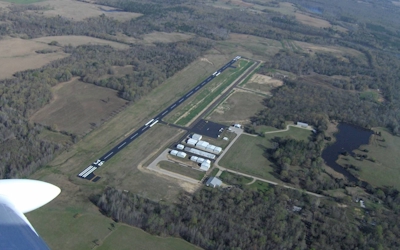
| WOOD COUNTY MINEOLA/QUITMAN TX |
| |
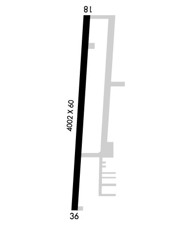
| Lat: N 3244.5 Long: W 09529.8 Elev: 433 Var: -02 Longest Runway: 4002 | ||
| AWOS: 118.9 CTAF: 122.8 | ||
| ||||||
| ||||||
|
| Rwy | Rwy | |||||||
| 4002x60 | 4002' | 4002x60 | 4002' | |||||
| Runway ID | Single Wheel | Double Wheel | Double Tandem Wheel | Dual Double Wheel |
| 18/36 | 12,500 | N/A | N/A | N/A |
| These numbers are Advisory and are not limits. The Airport Manager should have more accurate Weight Limits | ||||
 Airport Diagram might not be current. | |
| Facility Name: | WOOD COUNTY - COLLINS FLD |
| City Name: | MINEOLA/QUITMAN |
| County: | WOOD |
| State abbrev: | TX |
| State Name: | TEXAS |
| Ownership: | PUBLICLY OWNED |
| Use: | OPEN TO THE PUBLIC |
| Owner's Name: | WOOD COUNTY |
| Address: | WOOD COUNTY COURTHOUSE |
| QUITMAN, TX 75783 | |
| Owner's Phone: | 903-763-2716 |
| Manager's Name: | RANDY BATEMAN; EMERGENCY CONTACT 903-763-2201-SHERIFF DEPT. |
| Address: | 13790 FM 2710 |
| LINDALE, TX 75771 | |
| Phone: | (903) 714-3672 |
| FAA Region: | SOUTHWEST |
| FAA Field Office: | TEX |
| Date | Sunrise | Sunset |
|---|---|---|
| 09/24/21 Friday | 7:11 | 19:16 |
| 09/25/21 Saturday | 7:12 | 19:15 |
| 09/26/21 Sunday | 7:13 | 19:14 |
| 09/27/21 Monday | 7:13 | 19:12 |
| 09/28/21 Tuesday | 7:14 | 19:11 |
| 09/29/21 Wednesday | 7:15 | 19:10 |
| 09/30/21 Thursday | 7:15 | 19:08 |
| 10/01/21 Friday | 7:16 | 19:07 |
| 10/02/21 Saturday | 7:17 | 19:06 |
| 10/03/21 Sunday | 7:17 | 19:04 |
| 10/04/21 Monday | 7:18 | 19:03 |
| 10/05/21 Tuesday | 7:19 | 19:02 |
| 10/06/21 Wednesday | 7:19 | 19:00 |
| 10/07/21 Thursday | 7:20 | 18:59 |
| Airport Attendance Schedule | M-F 0900-1700 |
| Airport Status | OPERATIONAL (This Status can change at any time - please check NOTAMS) |
| Airport Lighting Schedule | MIRL RWY 18/36 PRESET LOW INTST DUSK-DAWN; TO INCR INTST ACTVT - CTAF. PAPI RWYS 18 & 36 OPR CONSLY. |
| Airport Storage Available | Tie Downs, Hanger |
| Extra Services Available | Flight Instruction |
| Wind Indicator | YES - (lighted) |
| Control Tower | NO |
| CTAF Frequency | 122.800 |
| Unicom Frequency | 122.800 |
| Rotating Beacon Color | CLEAR-GREEN (Light Land Airport) |
| Segmented Circle | YES |
| Landing Fee |
| Airport Inspected | STATE - performed by PRIVATE CONTRACT PERSONNEL |
| Inspection Date | 03/29/2019 |
| Type of Fuel Available | Grade 100LL, JET A (freeze point -40C); -10SELF SVC FUEL AVBL 24 HRS WITH MAJOR CREDIT CARD. |
| Airframe Repair Service | MAJOR |
| Power Plant Repair Service | MAJOR |
| Latitude | N3244.5 |
| Longitude | W09529.8 (ESTIMATED) |
| Arpt Elevation | 432ft (SURVEYED) |
| Magnetic Variation | 02E |
| 5 miles N; 04 NM SW OF QUITMAN. | of MINEOLA/QUITMAN |
| Traffic Pattern Altitude | |
| Sectional Chart | DALLAS-FT WORTH |
| Operations (Reported) | Yearly | Avg. Daily |
|---|---|---|
| General Aviation Transient | 10000 | 27 |
| General Aviation Local | 12000 | 33 |
| Air Taxi | 0 | 0 |
| Commerical | 0 | 0 |
| Commuter | 0 | 0 |
| Military | 0 | 0 |
| Aircraft based on Field | |
|---|---|
| General Aviation Singles | 50 |
| General Aviation Multi | 4 |
| Jet Aircraft | 0 |
| General Aviation Helicopters | 3 |
| Military Aircraft | 0 |
| Gliders | 0 |
| Ultralights | 0 |
| FSS on field | NO |
| FSS tie-in | FORT WORTH |
| FSS Phone | 1-800-WX-BRIEF |
| Who issues Notams | JDD |
| Notam D service at airport | YES |
| ARTCC Name | FORT WORTH |
| Airport Certification | |
| Aircraft Rescue & Firefighting Index | None |
| Airport of Entry | No |
| Custom Landing Rights | No |
| Joint Civil/Military | No |
| Military Landing rights | No |
| BLUE TWY CNTRLN REFLECTORS. |
| WILDLIFE INVOF ARPT. |
| FOR CD CTC FORT WORTH ARTCC AT 817-858-7584. |
Airport Communications & Frequencies:
| |||||||||||||||||
| Runway: 18 | Runway: 36 | ||
| Mag heading: | 180° | Mag heading: | 0° |
| Rwy Slope: | .75% Up | Rwy Slope: | -.75% Down |
| Approach: | Approach: | ||
| Pattern: | Left Traffic | Pattern: | Left Traffic |
| Markings: | NONPRECISION INSTRUMENT | Markings: | NONPRECISION INSTRUMENT |
| Marking Condition: | FAIR | Marking Condition: | FAIR |
| Arresting Dev: | Arresting Dev: | ||
| Lat & Long: | N3244.9 W09529.8 | Lat. & Long.: | N3244.2 W09529.8 |
| Elev: | 402.5 ft. MSL | Elev: | 432.6 ft. MSL |
| TCH: | 30 ft. AGL | TCH: | 42 ft. AGL |
| Visual Glide Path: | 3.00 degrees | Visual Glide Path: | 3.00 degrees |
| Displaced Threshold: | No | Displaced Threshold: | No |
| Touchdown Zone: | YES | Touchdown Zone: | YES |
| Touchdown Elev.: | 421.1 feet | Touchdown Elev.: | 432.9 feet |
| Visual Glide Slope: | 2-Light PAPI on LEFT side of Runway | Visual Glide Slope: | 2-Light PAPI on LEFT side of Runway; PAPI UNUSBL 6 DEGS LEFT OF CNTRLN. |
| RVR Equipment: | RVR Equipment: | ||
| RVV Equipment: | NO | RVV Equipment: | NO |
| Approach Lights: | Approach Lights: | ||
| REIL: | NO | REIL: | NO |
| Centerline Lights: | NO | Centerline Lights: | NO |
| Touchdown lights: | NO | Touchdown lights: | NO |
| Runway Category: | Runway with a Non-precision Approach | Runway Category: | Runway with a Non-precision Approach |
| Declared Distances: | Declared Distances: | ||
| Obstructions: | TREES | Obstructions: | TREES |
| Marked: | NOT Marked/Lighted | Marked: | NOT Marked/Lighted |
| Clearance slope: | 20:1 | Clearance slope: | |
| Obstruction height: | 90 feet AGL | Obstruction height: | 70 feet AGL |
| Dist. from runway: | 2000 feet | Dist. from runway: | 201 feet |
| Centerline offset: | Centerline offset: | 243 feet right of centerline | |
| Comments: | Comments: | 50-70 FT TREES 57 FT FM THR TO 200 FT FM THR, 243 FT RIGHT. |
Thanks for using FltPlan.com
all rights reserved © 1999-2021 by Flight Plan LLC