
| WILLIAMSPORT RGNL WILLIAMSPORT PA |
| |
| Lat: N 4114.5 Long: W 07655.3 Elev: 528 Var: +10 Longest Runway: 6825 | ||
| AWOS: 125.22 Ground: 121.9 Tower: 119.1 | ||
| ||||||||||||||||||||||||||||||||||||||||||||
| ||||||||||||||||||||||||||||||||||||||||||||
| ||||||||||||||||||||||||||||||||||||||||||||
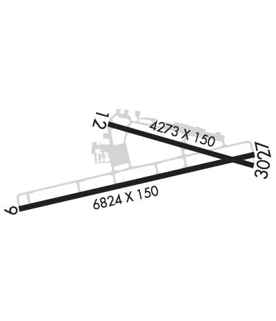
| Rwy | Rwy | |||||||
| 6825x150 | 6825' | 6825x150 | 6570' | 110.10 - 265° | ||||
| 4273x150 | 4273' | 4273x150 | 4273' | |||||
| Runway ID | Single Wheel | Double Wheel | Double Tandem Wheel | Dual Double Wheel |
| 09/27 | 65,000 | 100,000 | 190,000 | N/A |
| 12/30 | 200,000 | 200,000 | 400,000 | N/A |
| These numbers are Advisory and are not limits. The Airport Manager should have more accurate Weight Limits | ||||
 Airport Diagram might not be current. | |
| Facility Name: | WILLIAMSPORT RGNL |
| City Name: | WILLIAMSPORT |
| County: | LYCOMING |
| State abbrev: | PA |
| State Name: | PENNSYLVANIA |
| Ownership: | PUBLICLY OWNED |
| Use: | OPEN TO THE PUBLIC |
| Owner's Name: | WILLIAMSPORT MUNI ARPT AUTH |
| Address: | 724 AIRPORT RD |
| MONTOURSVILLE, PA 17754 | |
| Owner's Phone: | 570-368-2444 |
| Manager's Name: | RICHARD HOWELL |
| Address: | 724 AIRPORT RD |
| MONTOURSVILLE, PA 17754 | |
| Phone: | 570-368-2444 |
| FAA Region: | EASTERN |
| FAA Field Office: | HAR |

| Date | Sunrise | Sunset |
|---|---|---|
| 09/24/21 Friday | 6:57 | 19:02 |
| 09/25/21 Saturday | 6:58 | 19:00 |
| 09/26/21 Sunday | 6:59 | 18:58 |
| 09/27/21 Monday | 7:00 | 18:57 |
| 09/28/21 Tuesday | 7:01 | 18:55 |
| 09/29/21 Wednesday | 7:02 | 18:53 |
| 09/30/21 Thursday | 7:03 | 18:52 |
| 10/01/21 Friday | 7:04 | 18:50 |
| 10/02/21 Saturday | 7:05 | 18:48 |
| 10/03/21 Sunday | 7:06 | 18:47 |
| 10/04/21 Monday | 7:07 | 18:45 |
| 10/05/21 Tuesday | 7:08 | 18:43 |
| 10/06/21 Wednesday | 7:09 | 18:42 |
| 10/07/21 Thursday | 7:10 | 18:40 |
| Airport Attendance Schedule | 7 Days A Week 0630-2230; AFTER HRS BY PRIOR COORDINATION CALL 570-368-2651. |
| Airport Status | OPERATIONAL (This Status can change at any time - please check NOTAMS) |
| Airport Lighting Schedule | DUSK-DAWN. WHEN ATCT CLSD ACTVT MALSR RWY 27; REIL RWY 09; HIRL RWY 09/27; MIRL RWY 12/30; AND TWY LGTS - CTAF. PAPI RWYS 09, 12 & 30 OPER CONSLY. MIRL RWY 12/30, CLICK THREE TIMES FOR MEDIUM INTST. |
| Airport Storage Available | Tie Downs, Hanger |
| Extra Services Available | Avionics, Cargo Handling, Flight Instruction, Aircraft Rental, Aircraft Sales |
| Wind Indicator | YES - (lighted) |
| Control Tower | YES |
| CTAF Frequency | 119.100 |
| Unicom Frequency | 122.950 |
| Rotating Beacon Color | CLEAR-GREEN (Light Land Airport) |
| Segmented Circle | YES |
| Landing Fee | YES |
| Airport Inspected | FEDERAL - performed by FAA AIRPORTS FIELD PERSONNEL |
| Inspection Date | 07/26/2021 |
| Type of Fuel Available | Grade 100LL, JET A (freeze point -40C); -10FUEL & SVCS AVBL 0530-2200 DAILY; AFTER HRS BY PRIOR COORDINATION CALL 570-368-2651. |
| Airframe Repair Service | MAJOR |
| Power Plant Repair Service | MAJOR |
| Latitude | N4114.5 |
| Longitude | W07655.3 (ESTIMATED) |
| Arpt Elevation | 528ft (SURVEYED) |
| Magnetic Variation | 10W |
| 4 miles E | of WILLIAMSPORT |
| Traffic Pattern Altitude | |
| Sectional Chart | NEW YORK |
| Operations (Reported) | Yearly | Avg. Daily |
|---|---|---|
| General Aviation Transient | 9036 | 25 |
| General Aviation Local | 3037 | 8 |
| Air Taxi | 2967 | 8 |
| Commerical | 3 | 0 |
| Commuter | 0 | 0 |
| Military | 275 | 1 |
| Aircraft based on Field | |
|---|---|
| General Aviation Singles | 34 |
| General Aviation Multi | 9 |
| Jet Aircraft | 2 |
| General Aviation Helicopters | 1 |
| Military Aircraft | 0 |
| Gliders | 0 |
| Ultralights | 0 |
| FSS on field | NO |
| FSS tie-in | WILLIAMSPORT |
| FSS Phone | 1-800-WX-BRIEF |
| Who issues Notams | IPT |
| Notam D service at airport | YES |
| ARTCC Name | NEW YORK |
| Airport Certification | AIRPORT RECEIVING SCHEDULED AIR CARRIER SERVICE FROM CARRIERS CERTIFICATED BY THE CIVIL AERONAUTICS BOARD; PPR 12 HRS FOR UNSKED ACR OPNS WITH MORE THAN 30 PSGR SEATS 2300-0600 LCL DLY CALL AMGR 570-368-2444. INDEX "B" COVERAGE AVAIL UPON REQUEST CALL AMGR 570-368-2444. |
| Aircraft Rescue & Firefighting Index | AIRPORT HAS A CERTIFICATE UNDER CFR PART 139 |
| Airport of Entry | No |
| Custom Landing Rights | No |
| Joint Civil/Military | No |
| Military Landing rights | YES |
| NATIONAL PLAN OF INTEGRATED AIRPORT SYSTEMS (NPIAS) |
| GRANT AGREEMENTS UNDER FAAP/ADAP/AIP |
| ASSURANCES PURSUANT TO TITLE VI, CIVIL RIGHTS ACT OF 1964 |
| AGREEMENT UNDER DLAND OR DCLA HAS EXPIRED. |
| COMPLIANCE WITH ACCESSIBILITY TO THE HANDICAPPED |
| DEER & BIRDS ON & INVOF ARPT SPCLY AER 27 & AER 30 |
| TWY 'J' CLSD TO ACFT WITH WING SPAN OVER 78 FT. |
| FOR LANDSIDE ACCESS FM ARPT AFTER HRS USE COMPUTERIZED GATE SYSTEM AT EAST END OR FBO APRON. |
| UNLGTD CRANE 90 FT AGL .5 MI SE AER 30 PERMLY. |
| ARPT CLSD TO BANNER TOWING OPNS. |
| COLD TEMPERATURE AIRPORT. ALTITUDE CORRECTION REQUIRED AT OR BELOW -14C. |
| FOR CD IF UNA TO CTC ON FSS FREQ, CTC NEW YORK ARTCC AT 631-468-1425. |
Airport Communications & Frequencies:
| |||||||||||||||||||
| Runway: 09 | Runway: 27 | ||
| Mag heading: | 87° | Mag heading: | 267° |
| Rwy Slope: | .17% Up | Rwy Slope: | -.17% Down |
| Approach: | Approach: | ILS/DME | |
| Pattern: | Left Traffic | Pattern: | Right Traffic |
| Markings: | PRECISION INSTRUMENT | Markings: | PRECISION INSTRUMENT |
| Marking Condition: | FAIR | Marking Condition: | FAIR |
| Arresting Dev: | Arresting Dev: | ||
| Lat & Long: | N4114.3 W07656.1 | Lat. & Long.: | N4114.6 W07654.7 |
| Elev: | 513.8 ft. MSL | Elev: | 525.2 ft. MSL |
| TCH: | 49 ft. AGL | TCH: | |
| Visual Glide Path: | 3.00 degrees | Visual Glide Path: | |
| Displaced Threshold: | No | Displaced Threshold: | 255 feet |
| Touchdown Zone: | YES | Touchdown Zone: | YES |
| Touchdown Elev.: | 521.0 feet | Touchdown Elev.: | 527.1 feet |
| Visual Glide Slope: | 4-Light PAPI on LEFT side of Runway; RWY 09 PAPI BAFFLED UNUSBL BYD 2 DEGS R OF CRS. | Visual Glide Slope: | |
| RVR Equipment: | RVR Equipment: | ||
| RVV Equipment: | NO | RVV Equipment: | NO |
| Approach Lights: | Approach Lights: | MALSR - 1,400 foot medium intensity approach lighting system with runway alignment indicator lights | |
| REIL: | YES | REIL: | NO |
| Centerline Lights: | NO | Centerline Lights: | NO |
| Touchdown lights: | NO | Touchdown lights: | NO |
| Runway Category: | Runway with a Non-precision Approach having visibility minimums greater than 3/4 mile | Runway Category: | Precision Instrument Runway |
| Declared Distances: | TORA:6825' TODA:6825' ASDA:6073' LDA:6073' | Declared Distances: | TORA:6825' TODA:6825' ASDA:6318' LDA:6063' |
| Obstructions: | TREES | Obstructions: | TREES |
| Marked: | NOT Marked/Lighted | Marked: | NOT Marked/Lighted |
| Clearance slope: | 11:1; 18:1 TO DSPLCD THLD. | Clearance slope: | 10:1 |
| Obstruction height: | 45 feet AGL | Obstruction height: | 72 feet AGL |
| Dist. from runway: | 732 feet | Dist. from runway: | 962 feet |
| Centerline offset: | 348 left of centerline | Centerline offset: | 533 feet left of centerline |
| Comments: | Comments: |
| Runway: 12 | Runway: 30 | ||
| Mag heading: | 116° | Mag heading: | 296° |
| Rwy Slope: | .06% Up | Rwy Slope: | -.06% Down |
| Approach: | Approach: | ||
| Pattern: | Left Traffic | Pattern: | Right Traffic |
| Markings: | NONPRECISION INSTRUMENT | Markings: | NONPRECISION INSTRUMENT |
| Marking Condition: | FAIR | Marking Condition: | FAIR |
| Arresting Dev: | Arresting Dev: | ||
| Lat & Long: | N4114.7 W07655.6 | Lat. & Long.: | N4114.5 W07654.7 |
| Elev: | 523.0 ft. MSL | Elev: | 525.6 ft. MSL |
| TCH: | 45 ft. AGL | TCH: | 41 ft. AGL |
| Visual Glide Path: | 3.75 degrees | Visual Glide Path: | 4.00 degrees |
| Displaced Threshold: | No | Displaced Threshold: | No |
| Touchdown Zone: | YES | Touchdown Zone: | YES |
| Touchdown Elev.: | 528.1 feet | Touchdown Elev.: | 528.1 feet |
| Visual Glide Slope: | 2-Light PAPI on LEFT side of Runway | Visual Glide Slope: | 2-Light PAPI on LEFT side of Runway; RWY 30 PAPI BAFFLED UNUSBL BYD 7 DEGS L OF CRS. |
| RVR Equipment: | RVR Equipment: | ||
| RVV Equipment: | NO | RVV Equipment: | NO |
| Approach Lights: | Approach Lights: | ||
| REIL: | NO | REIL: | NO |
| Centerline Lights: | NO | Centerline Lights: | NO |
| Touchdown lights: | NO | Touchdown lights: | NO |
| Runway Category: | Runway with a Non-precision Approach having visibility minimums greater than 3/4 mile | Runway Category: | Runway with a Non-precision Approach having visibility minimums greater than 3/4 mile |
| Declared Distances: | TORA:4273' TODA:4273' ASDA:4273' LDA:4273' | Declared Distances: | TORA:4273' TODA:4273' ASDA:4273' LDA:4273' |
| Obstructions: | TREES | Obstructions: | TREES |
| Marked: | NOT Marked/Lighted | Marked: | NOT Marked/Lighted |
| Clearance slope: | 19:1 | Clearance slope: | 11:1 |
| Obstruction height: | 85 feet AGL | Obstruction height: | 72 feet AGL |
| Dist. from runway: | 1855 feet | Dist. from runway: | 1032 feet |
| Centerline offset: | 394 right of centerline | Centerline offset: | 280 feet right of centerline |
| Comments: | Comments: |
Thanks for using FltPlan.com
all rights reserved © 1999-2021 by Flight Plan LLC