
| IOWA CITY MUNI IOWA CITY IA |
| |
| Lat: N 4138.4 Long: W 09132.9 Elev: 684 Var: +01 Longest Runway: 5002 | ||
| Clr Del: 119.05 AWOS: 128.07 CTAF: 122.8 | ||
| ||||||||||||||||||||||||||||||||||||||||||||
| ||||||||||||||||||||||||||||||||||||||||||||
| ||||||||||||||||||||||||||||||||||||||||||||
| Rwy | Rwy | |||||||
| 5002x100 | 5002' | 5002x100 | 4196' | |||||
| 3900x75 | 3900' | 3900x75 | 3900' | |||||
| Runway ID | Single Wheel | Double Wheel | Double Tandem Wheel | Dual Double Wheel |
| 07/25 | 25,000 | 45,000 | N/A | N/A |
| 12/30 | 15,000 | 20,000 | N/A | N/A |
| These numbers are Advisory and are not limits. The Airport Manager should have more accurate Weight Limits | ||||
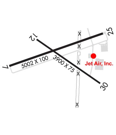 Airport Diagram might not be current. | |
| Facility Name: | IOWA CITY MUNI |
| City Name: | IOWA CITY |
| County: | JOHNSON |
| State abbrev: | IA |
| State Name: | IOWA |
| Ownership: | PUBLICLY OWNED |
| Use: | OPEN TO THE PUBLIC |
| Owner's Name: | CITY OF IOWA CITY |
| Address: | 410 EAST WASHINGTON |
| IOWA CITY, IA 52240 | |
| Owner's Phone: | 319-356-5010 |
| Manager's Name: | MICHAEL THARP |
| Address: | 1801 S. RIVERSIDE |
| IOWA CITY, IA 52246 | |
| Phone: | 319-356-5045 |
| FAA Region: | CENTRAL |
| FAA Field Office: | NONE |
| Date | Sunrise | Sunset |
|---|---|---|
| 09/24/21 Friday | 6:55 | 19:00 |
| 09/25/21 Saturday | 6:56 | 18:59 |
| 09/26/21 Sunday | 6:58 | 18:57 |
| 09/27/21 Monday | 6:59 | 18:55 |
| 09/28/21 Tuesday | 7:00 | 18:53 |
| 09/29/21 Wednesday | 7:01 | 18:52 |
| 09/30/21 Thursday | 7:02 | 18:50 |
| 10/01/21 Friday | 7:03 | 18:48 |
| 10/02/21 Saturday | 7:04 | 18:47 |
| 10/03/21 Sunday | 7:05 | 18:45 |
| 10/04/21 Monday | 7:06 | 18:43 |
| 10/05/21 Tuesday | 7:07 | 18:42 |
| 10/06/21 Wednesday | 7:08 | 18:40 |
| 10/07/21 Thursday | 7:09 | 18:38 |
| Airport Attendance Schedule | 7 Days A Week 0630-2030 |
| Airport Status | OPERATIONAL (This Status can change at any time - please check NOTAMS) |
| Airport Lighting Schedule | MIRL RYS 07/25 & 12/30 PRESET LOW INTST; TO INCR INTST & ACTVT PAPI RYS 07 & 25 - CTAF. |
| Airport Storage Available | Tie Downs, Hanger |
| Extra Services Available | Charter, Flight Instruction, Aircraft Rental, Aircraft Sales |
| Wind Indicator | YES - (lighted) |
| Control Tower | NO |
| CTAF Frequency | 122.800 |
| Unicom Frequency | 122.800 |
| Rotating Beacon Color | CLEAR-GREEN (Light Land Airport) |
| Segmented Circle | YES |
| Landing Fee | NO |
| Airport Inspected | STATE - performed by STATE AERONAUTICAL PERSONNEL |
| Inspection Date | 10/09/2019 |
| Type of Fuel Available | Grade 100LL, JET A (freeze point -40C) |
| Airframe Repair Service | MAJOR |
| Power Plant Repair Service | MAJOR |
| Latitude | N4138.4 |
| Longitude | W09132.9 (ESTIMATED) |
| Arpt Elevation | 683ft (SURVEYED) |
| Magnetic Variation | 01W |
| 2 miles SW | of IOWA CITY |
| Traffic Pattern Altitude | |
| Sectional Chart | CHICAGO |
| Operations (Reported) | Yearly | Avg. Daily |
|---|---|---|
| General Aviation Transient | 13100 | 36 |
| General Aviation Local | 3700 | 10 |
| Air Taxi | 2200 | 6 |
| Commerical | 0 | 0 |
| Commuter | 0 | 0 |
| Military | 287 | 1 |
| Aircraft based on Field | |
|---|---|
| General Aviation Singles | 60 |
| General Aviation Multi | 1 |
| Jet Aircraft | 7 |
| General Aviation Helicopters | 2 |
| Military Aircraft | 0 |
| Gliders | 3 |
| Ultralights | 0; ULTRALIGHT ACTIVITY DISCOURAGED-RDO RQRD. |
| FSS on field | NO |
| FSS tie-in | FORT DODGE |
| FSS Phone | 1-800-WX-BRIEF |
| Who issues Notams | IOW |
| Notam D service at airport | YES |
| ARTCC Name | CHICAGO |
| Airport Certification | |
| Aircraft Rescue & Firefighting Index | None |
| Airport of Entry | No |
| Custom Landing Rights | No |
| Joint Civil/Military | No |
| Military Landing rights | YES |
| NATIONAL PLAN OF INTEGRATED AIRPORT SYSTEMS (NPIAS) |
| GRANT AGREEMENTS UNDER FAAP/ADAP/AIP |
| ASSURANCES PURSUANT TO TITLE VI, CIVIL RIGHTS ACT OF 1964 |
| AGREEMENT UNDER DLAND OR DCLA HAS EXPIRED. |
| NOISE ABATEMENT PROCEDURES IN EFFECT, CTC ARPT MGR 319-356-5045. |
| RY 25 DESIGNATED AS CALM WIND RY. |
| WATERFOWL & DEER ON & INVOF ARPT. |
| HEL ACTIVITY 3/4 MILE N OF ARPT INVOF UNIVERSITY OF IOWA HOSPITAL. |
| NUMEROUS UNLGTD CRANES 200 FT AGL 2 NM RDS OF ARPT. |
| GLIDER ACTIVITY ON & INVOF ARPT. |
| STADIUM WITHIN 3NM, CHECK FOR EVENTS. |
Airport Communications & Frequencies:
| |||||||||||||||||||||||
| Runway: 07 | Runway: 25 | ||
| Mag heading: | 72° | Mag heading: | 252° |
| Rwy Slope: | -.66% Down | Rwy Slope: | .66% Up |
| Approach: | Approach: | ||
| Pattern: | Right Traffic | Pattern: | Left Traffic |
| Markings: | NONPRECISION INSTRUMENT | Markings: | NONPRECISION INSTRUMENT |
| Marking Condition: | FAIR | Marking Condition: | FAIR |
| Arresting Dev: | Arresting Dev: | ||
| Lat & Long: | N4138.3 W09133.5 | Lat. & Long.: | N4138.6 W09132.4 |
| Elev: | 683.6 ft. MSL | Elev: | 650.4 ft. MSL |
| TCH: | 51 ft. AGL | TCH: | 42 ft. AGL |
| Visual Glide Path: | 3.50 degrees | Visual Glide Path: | 3.00 degrees |
| Displaced Threshold: | No | Displaced Threshold: | 806 feet |
| Touchdown Zone: | YES | Touchdown Zone: | YES |
| Touchdown Elev.: | 683.6 feet | Touchdown Elev.: | 662.5 feet |
| Visual Glide Slope: | 4-Light PAPI on LEFT side of Runway | Visual Glide Slope: | 4-Light PAPI on LEFT side of Runway |
| RVR Equipment: | RVR Equipment: | ||
| RVV Equipment: | NO | RVV Equipment: | NO |
| Approach Lights: | Approach Lights: | ||
| REIL: | YES | REIL: | YES |
| Centerline Lights: | NO | Centerline Lights: | NO |
| Touchdown lights: | NO | Touchdown lights: | NO |
| Runway Category: | Runway with a Visual Approach | Runway Category: | Runway with a Non-precision Approach having visibility minimums greater than 3/4 mile |
| Declared Distances: | TORA:5002' TODA:5152' ASDA:4902' LDA:5002' | Declared Distances: | TORA:5002' TODA:5002' ASDA:5002' LDA:4196' |
| Obstructions: | POLE | Obstructions: | TREE |
| Marked: | NOT Marked/Lighted | Marked: | NOT Marked/Lighted |
| Clearance slope: | 21:1 | Clearance slope: | 16:1; RY 25 APCH SLOPE 23:1 TO DSPLCD THLD. |
| Obstruction height: | 88 feet AGL | Obstruction height: | 46 feet AGL |
| Dist. from runway: | 2079 feet | Dist. from runway: | 950 feet |
| Centerline offset: | 263 right of centerline | Centerline offset: | 50 feet left of centerline |
| Comments: | Comments: |
| Runway: 12 | Runway: 30 | ||
| Mag heading: | 126° | Mag heading: | 306° |
| Rwy Slope: | -.32% Down | Rwy Slope: | .32% Up |
| Approach: | Approach: | ||
| Pattern: | Right Traffic | Pattern: | Left Traffic |
| Markings: | NONPRECISION INSTRUMENT | Markings: | NONPRECISION INSTRUMENT |
| Marking Condition: | FAIR | Marking Condition: | FAIR |
| Arresting Dev: | Arresting Dev: | ||
| Lat & Long: | N4138.5 W09133.2 | Lat. & Long.: | N4138.1 W09132.5 |
| Elev: | 661.0 ft. MSL | Elev: | 648.6 ft. MSL |
| TCH: | TCH: | ||
| Visual Glide Path: | Visual Glide Path: | ||
| Displaced Threshold: | No | Displaced Threshold: | No |
| Touchdown Zone: | YES | Touchdown Zone: | YES |
| Touchdown Elev.: | 661.0 feet | Touchdown Elev.: | 657.1 feet |
| Visual Glide Slope: | Visual Glide Slope: | ||
| RVR Equipment: | RVR Equipment: | ||
| RVV Equipment: | NO | RVV Equipment: | NO |
| Approach Lights: | Approach Lights: | ||
| REIL: | NO | REIL: | NO |
| Centerline Lights: | NO | Centerline Lights: | NO |
| Touchdown lights: | NO | Touchdown lights: | NO |
| Runway Category: | Runway with a Visual Approach | Runway Category: | Runway with a Non-precision Approach having visibility minimums greater than 3/4 mile |
| Declared Distances: | Declared Distances: | ||
| Obstructions: | TREE | Obstructions: | TREE |
| Marked: | NOT Marked/Lighted | Marked: | NOT Marked/Lighted |
| Clearance slope: | 12:1 | Clearance slope: | 15:1 |
| Obstruction height: | 112 feet AGL | Obstruction height: | 77 feet AGL |
| Dist. from runway: | 1625 feet | Dist. from runway: | 1375 feet |
| Centerline offset: | 135 left of centerline | Centerline offset: | 400 feet left of centerline |
| Comments: | Comments: |
Thanks for using FltPlan.com
all rights reserved © 1999-2021 by Flight Plan LLC