
| DWIGHT D EISENHOWER NTL ARPT WICHITA KS |
| |
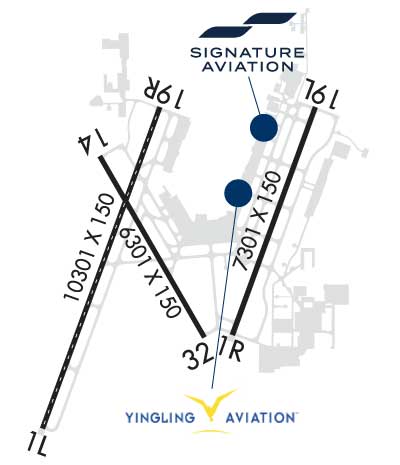
| Lat: N 3739.0 Long: W 09726.0 Elev: 1333 Var: -04 Longest Runway: 10301 | ||
| Clr Del: 125.7 Dept. ATIS: 125.15 Arr. ATIS: 125.15 Ground: 121.9 Tower: 118.2 | ||

| |||||||||||||||||||||||||||||||||||||||||||||||||||||||||||||||||||||
| |||||||||||||||||||||||||||||||||||||||||||||||||||||||||||||||||||||
| |||||||||||||||||||||||||||||||||||||||||||||||||||||||||||||||||||||
| |||||||||||||||||||||||||||||||||||||||||||||||||||||||||||||||||||||
| |||||||||||||||||||||||||||||||||||||||||||||||||||||||||||||||||||||
| Rwy | Rwy | |||||||
| 10301x150 | 10301' | 109.10 - 016° | 10301x150 | 10301' | 110.50 - 196° | |||
| 7301x150 | 7301' | 110.30 - 016° | 7301x150 | 7301' | 111.55 - 196° | |||
| 6301x150 | 6301' | 6301x150 | 6301' | |||||
| Runway ID | Single Wheel | Double Wheel | Double Tandem Wheel | Dual Double Wheel |
| 01L/19R | 100,000 | 210,000 | 300,000 | N/A |
| 01R/19L | 125,000 | 240,000 | 400,000 | N/A |
| 14/32 | 100,000 | 190,000 | 280,000 | N/A |
| These numbers are Advisory and are not limits. The Airport Manager should have more accurate Weight Limits | ||||
 Airport Diagram might not be current. | |
| Facility Name: | WICHITA DWIGHT D EISENHOWER NTL |
| City Name: | WICHITA |
| County: | SEDGWICK |
| State abbrev: | KS |
| State Name: | KANSAS |
| Ownership: | PUBLICLY OWNED |
| Use: | OPEN TO THE PUBLIC |
| Owner's Name: | WICHITA AIRPORT AUTHORITY |
| Address: | 2173 AIR CARGO ROAD |
| WICHITA, KS 67209 | |
| Owner's Phone: | 316-946-4700 |
| Manager's Name: | MR. VICTOR WHITE, A.A.E. |
| Address: | 2173 AIR CARGO ROAD |
| WICHITA, KS 67209 | |
| Phone: | 316-946-4700 |
| FAA Region: | CENTRAL |
| FAA Field Office: | NONE |

| Date | Sunrise | Sunset |
|---|---|---|
| 09/24/21 Friday | 7:19 | 19:24 |
| 09/25/21 Saturday | 7:20 | 19:22 |
| 09/26/21 Sunday | 7:21 | 19:21 |
| 09/27/21 Monday | 7:22 | 19:19 |
| 09/28/21 Tuesday | 7:22 | 19:18 |
| 09/29/21 Wednesday | 7:23 | 19:16 |
| 09/30/21 Thursday | 7:24 | 19:15 |
| 10/01/21 Friday | 7:25 | 19:13 |
| 10/02/21 Saturday | 7:26 | 19:12 |
| 10/03/21 Sunday | 7:27 | 19:10 |
| 10/04/21 Monday | 7:28 | 19:09 |
| 10/05/21 Tuesday | 7:29 | 19:07 |
| 10/06/21 Wednesday | 7:30 | 19:06 |
| 10/07/21 Thursday | 7:30 | 19:04 |
| Airport Attendance Schedule | CONTINUOUS |
| Airport Status | OPERATIONAL (This Status can change at any time - please check NOTAMS) |
| Airport Lighting Schedule | |
| Airport Storage Available | Tie Downs, Hanger |
| Extra Services Available | Air Freight, Air Ambulance, Avionics, Cargo Handling, Charter, Flight Instruction, Aircraft Rental, Aircraft Sales |
| Wind Indicator | YES - (lighted) |
| Control Tower | YES |
| CTAF Frequency | |
| Unicom Frequency | 122.950 |
| Rotating Beacon Color | CLEAR-GREEN (Light Land Airport) |
| Segmented Circle | NO |
| Landing Fee | NO |
| Airport Inspected | FEDERAL - performed by FAA AIRPORTS FIELD PERSONNEL |
| Inspection Date | 06/03/2021 |
| Type of Fuel Available | Grade 100LL, JET A (freeze point -40C) |
| Airframe Repair Service | MAJOR |
| Power Plant Repair Service | MAJOR |
| Latitude | N3739.0 |
| Longitude | W09726.0 (ESTIMATED) |
| Arpt Elevation | 1332ft (SURVEYED) |
| Magnetic Variation | 04E |
| 5 miles SW | of WICHITA |
| Traffic Pattern Altitude | |
| Sectional Chart | WICHITA |
| Operations (Reported) | Yearly | Avg. Daily |
|---|---|---|
| General Aviation Transient | 32006 | 88 |
| General Aviation Local | 8971 | 25 |
| Air Taxi | 16060 | 44 |
| Commerical | 13386 | 37 |
| Commuter | 0 | 0 |
| Military | 16547 | 45 |
| Aircraft based on Field | |
|---|---|
| General Aviation Singles | 77 |
| General Aviation Multi | 22 |
| Jet Aircraft | 105 |
| General Aviation Helicopters | 4 |
| Military Aircraft | 0 |
| Gliders | 0 |
| Ultralights | 0 |
| FSS on field | NO |
| FSS tie-in | WICHITA |
| FSS Phone | 1-800-WX-BRIEF |
| Who issues Notams | ICT |
| Notam D service at airport | YES |
| ARTCC Name | KANSAS CITY |
| Airport Certification | AIRPORT RECEIVING SCHEDULED AIR CARRIER SERVICE FROM CARRIERS CERTIFICATED BY THE CIVIL AERONAUTICS BOARD |
| Aircraft Rescue & Firefighting Index | AIRPORT HAS A CERTIFICATE UNDER CFR PART 139 |
| Airport of Entry | No |
| Custom Landing Rights | YES |
| Joint Civil/Military | No |
| Military Landing rights | YES |
| NATIONAL PLAN OF INTEGRATED AIRPORT SYSTEMS (NPIAS) |
| GRANT AGREEMENTS UNDER FAAP/ADAP/AIP |
| ASSURANCES PURSUANT TO TITLE VI, CIVIL RIGHTS ACT OF 1964 |
| THIS AIRPORT HAS BEEN SURVEYED BY THE NATIONAL GEODETIC SURVEY. |
| ATCT HAS LIMITED VISIBILITY OF TERMINAL GATES 1-8. |
| TWY H CLSD TO ACFT WITH WINGSPAN MORE THAN 75 FT. TWY H CONGESTED AND NOT VISIBLE FROM ATCT; USE CAUTION. |
| TWY L AND L1 CLSD TO ACFT WITH WINGSPAN MORE THAN 118FT. |
| TWY P CLSD TO ACFT WITH WINGSPAN MORE THAN 79FT. |
| NOTE: SEE SPECIAL NOTICES-CONTINUOUS POWER FACILITIES. |
| ACFT ENG RUNS ABV IDLE NOT APPROVED ON ACFT PRKG RAMPS. |
| CALL FOR PUSHBACK NOT REQUIRED. |
| PPR REQUIRED FOR ACFT CARRYING CLASS 1 - DIVISION 1.1; 1.2 OR 1.3 EXPLOSIVES AS DEFINED BY 49 CFR 173.50 OR AS AMENDED. |
| TWYS F, G, H, J, P AND ALL PARKING RAMPS ARE NON-MOVEMENT AREAS. |
| FLIGHT NOTIFICATION SERVICE (ADCUS) AVBL. |
| MIGRATORY BIRDS ON AND INVOF ARPT. |
Airport Communications & Frequencies:
| ||||||||||||||||||||||||||||||||||||||||||||||||||||||||
| Runway: 01L | Runway: 19R | ||
| Mag heading: | 16° | Mag heading: | 196° |
| Rwy Slope: | .17% Up | Rwy Slope: | -.17% Down |
| Approach: | ILS | Approach: | ILS |
| Pattern: | Left Traffic | Pattern: | Right Traffic |
| Markings: | PRECISION INSTRUMENT | Markings: | PRECISION INSTRUMENT |
| Marking Condition: | GOOD | Marking Condition: | GOOD |
| Arresting Dev: | Arresting Dev: | ||
| Lat & Long: | N3738.1 W09726.8 | Lat. & Long.: | N3739.7 W09726.0 |
| Elev: | 1312.6 ft. MSL | Elev: | 1329.7 ft. MSL |
| TCH: | TCH: | ||
| Visual Glide Path: | Visual Glide Path: | ||
| Displaced Threshold: | No | Displaced Threshold: | No |
| Touchdown Zone: | YES | Touchdown Zone: | YES |
| Touchdown Elev.: | 1314.2 feet | Touchdown Elev.: | 1329.7 feet |
| Visual Glide Slope: | Visual Glide Slope: | ||
| RVR Equipment: | TOUCHDOWN-MIDFIELD-ROLLOUT | RVR Equipment: | TOUCHDOWN-MIDFIELD-ROLLOUT |
| RVV Equipment: | NO | RVV Equipment: | NO |
| Approach Lights: | ALSF2 - standard 2,400 foot high intensity approach lighting system with sequenced flashers, Category II or III | Approach Lights: | MALSR - 1,400 foot medium intensity approach lighting system with runway alignment indicator lights |
| REIL: | NO | REIL: | NO |
| Centerline Lights: | YES | Centerline Lights: | YES |
| Touchdown lights: | YES | Touchdown lights: | NO |
| Runway Category: | Precision Instrument Runway | Runway Category: | Precision Instrument Runway |
| Declared Distances: | TORA:10301' TODA:10301' ASDA:10301' LDA:10301' | Declared Distances: | TORA:10301' TODA:10301' ASDA:10301' LDA:10301' |
| Runway: 01R | Runway: 19L | ||
| Mag heading: | 16° | Mag heading: | 196° |
| Rwy Slope: | -.02% Down | Rwy Slope: | .02% Up |
| Approach: | ILS/DME | Approach: | ILS/DME |
| Pattern: | Right Traffic | Pattern: | Left Traffic |
| Markings: | PRECISION INSTRUMENT | Markings: | PRECISION INSTRUMENT |
| Marking Condition: | GOOD | Marking Condition: | GOOD |
| Arresting Dev: | Arresting Dev: | ||
| Lat & Long: | N3738.6 W09725.6 | Lat. & Long.: | N3739.7 W09725.1 |
| Elev: | 1320.9 ft. MSL | Elev: | 1319.8 ft. MSL |
| TCH: | TCH: | 55 ft. AGL | |
| Visual Glide Path: | Visual Glide Path: | 3.00 degrees | |
| Displaced Threshold: | No | Displaced Threshold: | No |
| Touchdown Zone: | YES | Touchdown Zone: | YES |
| Touchdown Elev.: | 1320.9 feet | Touchdown Elev.: | 1319.9 feet |
| Visual Glide Slope: | Visual Glide Slope: | 4-Light PAPI on LEFT side of Runway | |
| RVR Equipment: | TOUCHDOWN-ROLLOUT | RVR Equipment: | TOUCHDOWN-ROLLOUT |
| RVV Equipment: | NO | RVV Equipment: | NO |
| Approach Lights: | MALSR - 1,400 foot medium intensity approach lighting system with runway alignment indicator lights | Approach Lights: | MALSR - 1,400 foot medium intensity approach lighting system with runway alignment indicator lights |
| REIL: | NO | REIL: | NO |
| Centerline Lights: | NO | Centerline Lights: | NO |
| Touchdown lights: | NO | Touchdown lights: | NO |
| Runway Category: | Precision Instrument Runway | Runway Category: | Precision Instrument Runway |
| Declared Distances: | TORA:7301' TODA:7301' ASDA:7301' LDA:7301' | Declared Distances: | TORA:7301' TODA:7301' ASDA:7301' LDA:7301' |
| Runway: 14 | Runway: 32 | ||
| Mag heading: | 146° | Mag heading: | 326° |
| Rwy Slope: | -.17% Down | Rwy Slope: | .17% Up |
| Approach: | Approach: | ||
| Pattern: | Left Traffic | Pattern: | Left Traffic |
| Markings: | NONPRECISION INSTRUMENT | Markings: | BASIC |
| Marking Condition: | GOOD | Marking Condition: | GOOD |
| Arresting Dev: | Arresting Dev: | ||
| Lat & Long: | N3739.5 W09726.4 | Lat. & Long.: | N3738.6 W09725.8 |
| Elev: | 1332.1 ft. MSL | Elev: | 1321.6 ft. MSL |
| TCH: | 50 ft. AGL | TCH: | 53 ft. AGL |
| Visual Glide Path: | 3.00 degrees | Visual Glide Path: | 3.00 degrees |
| Displaced Threshold: | No | Displaced Threshold: | No |
| Touchdown Zone: | YES | Touchdown Zone: | YES |
| Touchdown Elev.: | 1332.5 feet | Touchdown Elev.: | 1321.7 feet |
| Visual Glide Slope: | 4-Light PAPI on LEFT side of Runway | Visual Glide Slope: | 4-Light PAPI on LEFT side of Runway |
| RVR Equipment: | RVR Equipment: | ||
| RVV Equipment: | NO | RVV Equipment: | NO |
| Approach Lights: | Approach Lights: | ||
| REIL: | YES | REIL: | YES |
| Centerline Lights: | NO | Centerline Lights: | NO |
| Touchdown lights: | NO | Touchdown lights: | NO |
| Runway Category: | D | Runway Category: | D |
| Declared Distances: | TORA:6301' TODA:6301' ASDA:6301' LDA:6301' | Declared Distances: | TORA:6301' TODA:6301' ASDA:6301' LDA:6301' |
Thanks for using FltPlan.com
all rights reserved © 1999-2021 by Flight Plan LLC