
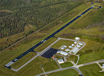
| MOUNT WASHINGTON RGNL WHITEFIELD NH |
| |
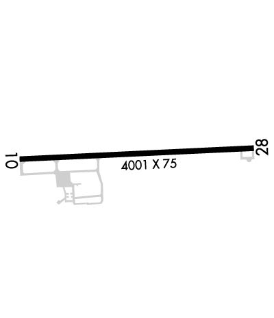
| Lat: N 4422.1 Long: W 07132.7 Elev: 1072 Var: +17 Longest Runway: 4001 | ||
| AWOS: 118.52 CTAF: 122.8 | ||
| ||||||||||||||||||||||||||||||||||||||||||||
| ||||||||||||||||||||||||||||||||||||||||||||
| ||||||||||||||||||||||||||||||||||||||||||||
| ||||||||||||||||||||||||||||||||||||||||||||
| ||||||||||||||||||||||||||||||||||||||||||||
| Rwy | Rwy | |||||||
| 4001x75 | 4001' | 109.50 - 104° | 4001x75 | 4001' | ||||
| Runway ID | Single Wheel | Double Wheel | Double Tandem Wheel | Dual Double Wheel |
| 10/28 | 30,000 | N/A | N/A | N/A |
| These numbers are Advisory and are not limits. The Airport Manager should have more accurate Weight Limits | ||||
 Airport Diagram might not be current. | |
| Facility Name: | MOUNT WASHINGTON RGNL |
| City Name: | WHITEFIELD |
| County: | COOS |
| State abbrev: | NH |
| State Name: | NEW HAMPSHIRE |
| Ownership: | PUBLICLY OWNED |
| Use: | OPEN TO THE PUBLIC |
| Owner's Name: | TOWN OF WHITEFIELD |
| Address: | 56 LITTLETON RD |
| WHITEFIELD, NH 03598 | |
| Owner's Phone: | 603-837-2551 |
| Manager's Name: | WENDY ROBERTS |
| Address: | 56 LITTLETON ROAD |
| WHITEFIELD, NH 03598 | |
| Phone: | 603-631-0621; AMGR CELL: (603) 631-0621 EMAIL: MTWASHINGTONREGIONALAIRPORT@GMAIL.COM |
| FAA Region: | NEW ENGLAND |
| FAA Field Office: | NONE |
| Date | Sunrise | Sunset |
|---|---|---|
| 09/24/21 Friday | 6:35 | 18:40 |
| 09/25/21 Saturday | 6:36 | 18:39 |
| 09/26/21 Sunday | 6:38 | 18:37 |
| 09/27/21 Monday | 6:39 | 18:35 |
| 09/28/21 Tuesday | 6:40 | 18:33 |
| 09/29/21 Wednesday | 6:41 | 18:31 |
| 09/30/21 Thursday | 6:42 | 18:29 |
| 10/01/21 Friday | 6:44 | 18:27 |
| 10/02/21 Saturday | 6:45 | 18:26 |
| 10/03/21 Sunday | 6:46 | 18:24 |
| 10/04/21 Monday | 6:47 | 18:22 |
| 10/05/21 Tuesday | 6:48 | 18:20 |
| 10/06/21 Wednesday | 6:50 | 18:18 |
| 10/07/21 Thursday | 6:51 | 18:16 |
| Airport Attendance Schedule | 7 Days A Week IREG |
| Airport Status | OPERATIONAL (This Status can change at any time - please check NOTAMS) |
| Airport Lighting Schedule | ACTVT REIL RWYS 10 & 28; PAPI RWY 10; MIRL RWY 10/28 - CTAF. |
| Airport Storage Available | Tie Downs |
| Extra Services Available | NONE |
| Wind Indicator | YES - (lighted) |
| Control Tower | NO |
| CTAF Frequency | 122.800 |
| Unicom Frequency | 122.800 |
| Rotating Beacon Color | CLEAR-GREEN (Light Land Airport) |
| Segmented Circle | YES |
| Landing Fee | YES; CTC ARPT FOR OVNGT PRKG. FEES VARY, SNGL ENG, MULTI ENG, COML. 1 NGT WAIVED WITH FUEL PURCHASE. |
| Airport Inspected | STATE - performed by STATE AERONAUTICAL PERSONNEL |
| Inspection Date | 08/17/2020 |
| Type of Fuel Available | Grade 100LL; -10SELF-SERVE FUEL AVAIL 24 HRS WITH CREDIT CARD. |
| Airframe Repair Service | MAJOR |
| Power Plant Repair Service | MAJOR |
| Latitude | N4422.1 |
| Longitude | W07132.7 (ESTIMATED) |
| Arpt Elevation | 1072ft (SURVEYED) |
| Magnetic Variation | 17W |
| 3 miles E | of WHITEFIELD |
| Traffic Pattern Altitude | 2000 |
| Sectional Chart | MONTREAL |
| Operations (Reported) | Yearly | Avg. Daily |
|---|---|---|
| General Aviation Transient | 4500 | 12 |
| General Aviation Local | 4500 | 12 |
| Air Taxi | 150 | 0 |
| Commerical | 0 | 0 |
| Commuter | 0 | 0 |
| Military | 350 | 1 |
| Aircraft based on Field | |
|---|---|
| General Aviation Singles | 26 |
| General Aviation Multi | 5 |
| Jet Aircraft | 0 |
| General Aviation Helicopters | 1 |
| Military Aircraft | 0 |
| Gliders | 0 |
| Ultralights | 0 |
| FSS on field | NO |
| FSS tie-in | BANGOR |
| FSS Phone | 1-800-WX-BRIEF |
| Who issues Notams | HIE |
| Notam D service at airport | YES |
| ARTCC Name | BOSTON |
| Airport Certification | |
| Aircraft Rescue & Firefighting Index | None |
| Airport of Entry | No |
| Custom Landing Rights | No |
| Joint Civil/Military | No |
| Military Landing rights | YES |
| NATIONAL PLAN OF INTEGRATED AIRPORT SYSTEMS (NPIAS) |
| GRANT AGREEMENTS UNDER FAAP/ADAP/AIP |
| ASSURANCES PURSUANT TO TITLE VI, CIVIL RIGHTS ACT OF 1964 |
| RWY 28 TRANS LINE ACRS APCH 20:1+, MKD WITH DAY-GLOW BALLS. |
| WILDLIFE ON & INVOF ARPT. |
| COLD TEMPERATURE RESTRICTED AIRPORT. ALTITUDE CORRECTION REQUIRED AT OR BELOW -29C. |
| RENTAL CAR AVBL BY REQ. CALL (603) 788-4568. |
| FOR CD IF UNA TO CTC ON FSS FREQ, CTC BOSTON ARTCC AT 603-879-6859 . |
| ARPT CONDS NOT RGLRY MNTD. |
| RISING TRRN LCTD 3 NM SE OF ARPT. |
Airport Communications & Frequencies:
| |||||||||
| Runway: 10 | Runway: 28 | ||
| Mag heading: | 104° | Mag heading: | 284° |
| Rwy Slope: | .59% Up | Rwy Slope: | -.59% Down |
| Approach: | LOCALIZER | Approach: | |
| Pattern: | Left Traffic | Pattern: | Right Traffic |
| Markings: | NONPRECISION INSTRUMENT | Markings: | NONPRECISION INSTRUMENT |
| Marking Condition: | GOOD | Marking Condition: | GOOD |
| Arresting Dev: | Arresting Dev: | ||
| Lat & Long: | N4422.0 W07133.2 | Lat. & Long.: | N4422.1 W07132.3 |
| Elev: | 1048.2 ft. MSL | Elev: | 1072.0 ft. MSL |
| TCH: | 45 ft. AGL | TCH: | |
| Visual Glide Path: | 3.50 degrees | Visual Glide Path: | |
| Displaced Threshold: | No | Displaced Threshold: | No |
| Touchdown Zone: | YES | Touchdown Zone: | YES |
| Touchdown Elev.: | 1057.1 feet | Touchdown Elev.: | 1072.0 feet |
| Visual Glide Slope: | 4-Light PAPI on LEFT side of Runway | Visual Glide Slope: | |
| RVR Equipment: | RVR Equipment: | ||
| RVV Equipment: | NO | RVV Equipment: | NO |
| Approach Lights: | Approach Lights: | ||
| REIL: | YES | REIL: | YES |
| Centerline Lights: | NO | Centerline Lights: | NO |
| Touchdown lights: | NO | Touchdown lights: | NO |
| Runway Category: | Runway with a Non-precision Approach | Runway Category: | Runway with a Visual Approach |
| Declared Distances: | Declared Distances: | ||
| Obstructions: | TREES | Obstructions: | BRUSH |
| Marked: | NOT Marked/Lighted | Marked: | NOT Marked/Lighted |
| Clearance slope: | 15:1 | Clearance slope: | |
| Obstruction height: | 14 feet AGL | Obstruction height: | 16 feet AGL |
| Dist. from runway: | 418 feet | Dist. from runway: | 215 feet |
| Centerline offset: | 66 right of centerline | Centerline offset: | 177 feet left of centerline |
| Comments: | Comments: | 7 FT TALL LOW GROWTH 60 FT - 135 FT FM RWY END, 116 FT RIGHT. |
Thanks for using FltPlan.com
all rights reserved © 1999-2021 by Flight Plan LLC