
| GREENWOOD MUNI INDIANAPOLIS IN |
| |
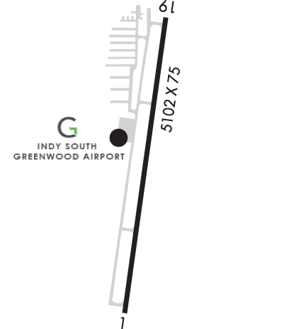
| Lat: N 3937.7 Long: W 08605.3 Elev: 822 Var: +02 Longest Runway: 5102 | ||
| AWOS: 118.52 CTAF: 123.0 | ||
| |||||||||||||||||||||||||||||||||||||||||||||||||||||||||||||||||||||
| |||||||||||||||||||||||||||||||||||||||||||||||||||||||||||||||||||||
| |||||||||||||||||||||||||||||||||||||||||||||||||||||||||||||||||||||
| Rwy | Rwy | |||||||
| 5102x75 | 5000' | 5102x75 | 5002' | |||||
| Runway ID | Single Wheel | Double Wheel | Double Tandem Wheel | Dual Double Wheel |
| 01/19 | N/A | N/A | N/A | N/A |
| These numbers are Advisory and are not limits. The Airport Manager should have more accurate Weight Limits | ||||
 Airport Diagram might not be current. | |
| Facility Name: | INDY SOUTH GREENWOOD |
| City Name: | INDIANAPOLIS |
| County: | JOHNSON |
| State abbrev: | IN |
| State Name: | INDIANA |
| Ownership: | PUBLICLY OWNED |
| Use: | OPEN TO THE PUBLIC |
| Owner's Name: | GREENWOOD BOAC |
| Address: | 300 S. MADISON AVE |
| GREENWOOD, IN 46142 | |
| Owner's Phone: | (317) 881-0887 |
| Manager's Name: | RICK FERRILL |
| Address: | 897 AIRPORT PKWY |
| GREENWOOD, IN 46143 | |
| Phone: | (317) 881-0887 |
| FAA Region: | GREAT LAKES |
| FAA Field Office: | CHI |
| Date | Sunrise | Sunset |
|---|---|---|
| 09/24/21 Friday | 7:34 | 19:39 |
| 09/25/21 Saturday | 7:35 | 19:37 |
| 09/26/21 Sunday | 7:35 | 19:35 |
| 09/27/21 Monday | 7:36 | 19:34 |
| 09/28/21 Tuesday | 7:37 | 19:32 |
| 09/29/21 Wednesday | 7:38 | 19:30 |
| 09/30/21 Thursday | 7:39 | 19:29 |
| 10/01/21 Friday | 7:40 | 19:27 |
| 10/02/21 Saturday | 7:41 | 19:26 |
| 10/03/21 Sunday | 7:42 | 19:24 |
| 10/04/21 Monday | 7:43 | 19:22 |
| 10/05/21 Tuesday | 7:44 | 19:21 |
| 10/06/21 Wednesday | 7:45 | 19:19 |
| 10/07/21 Thursday | 7:46 | 19:18 |
| Airport Attendance Schedule | MON-SAT 0700-1900, SUN 0800-1700; ATTENDANT AFT HRS CALL (317) 760-4047. |
| Airport Status | OPERATIONAL (This Status can change at any time - please check NOTAMS) |
| Airport Lighting Schedule | ACTVT REIL RWY 01; MIRL RWY 01/19 - CTAF. |
| Airport Storage Available | Tie Downs, Hanger |
| Extra Services Available | Flight Instruction, Aircraft Rental, Aircraft Sales |
| Wind Indicator | YES - (lighted) |
| Control Tower | NO |
| CTAF Frequency | 123.000 |
| Unicom Frequency | 123.000 |
| Rotating Beacon Color | CLEAR-GREEN (Light Land Airport) |
| Segmented Circle | NO |
| Landing Fee | NO |
| Airport Inspected | STATE - performed by STATE AERONAUTICAL PERSONNEL |
| Inspection Date | 02/27/2020 |
| Type of Fuel Available | Grade 100LL, JET A (freeze point -40C) |
| Airframe Repair Service | MAJOR |
| Power Plant Repair Service | MAJOR |
| Latitude | N3937.7 |
| Longitude | W08605.3 (ESTIMATED) |
| Arpt Elevation | 822ft (SURVEYED) |
| Magnetic Variation | 02W |
| 10 miles SE | of INDIANAPOLIS |
| Traffic Pattern Altitude | 800 |
| Sectional Chart | ST LOUIS |
| Operations (Reported) | Yearly | Avg. Daily |
|---|---|---|
| General Aviation Transient | 13992 | 38 |
| General Aviation Local | 12005 | 33 |
| Air Taxi | 805 | 2 |
| Commerical | 0 | 0 |
| Commuter | 0 | 0 |
| Military | 1142 | 3 |
| Aircraft based on Field | |
|---|---|
| General Aviation Singles | 75 |
| General Aviation Multi | 4 |
| Jet Aircraft | 6 |
| General Aviation Helicopters | 3 |
| Military Aircraft | 0 |
| Gliders | 0 |
| Ultralights | 0 |
| FSS on field | NO |
| FSS tie-in | TERRE HAUTE |
| FSS Phone | 1-800-WX-BRIEF |
| Who issues Notams | HUF |
| Notam D service at airport | YES |
| ARTCC Name | INDIANAPOLIS |
| Airport Certification | |
| Aircraft Rescue & Firefighting Index | None |
| Airport of Entry | No |
| Custom Landing Rights | No |
| Joint Civil/Military | No |
| Military Landing rights | No |
| NATIONAL PLAN OF INTEGRATED AIRPORT SYSTEMS (NPIAS) |
| GRANT AGREEMENTS UNDER FAAP/ADAP/AIP |
| ASSURANCES PURSUANT TO TITLE VI, CIVIL RIGHTS ACT OF 1964 |
| HIGH INTENSITY STUDENT TRAINING. |
| GCO AVBL ON FREQ 121.725 THRU INDIANAPOLIS CLNC AND FLIGHT SERVICES - TO ACTVT 4 SLOW CLICKS. IF UNAVBL CALL 317-227-5743. |
| SELF SVC FUEL AVBL 24 HRS. |
| RWY 01/1 9 10 FT DRAINAGE DITCH 125 FT R & L OF CNTRLN. |
Airport Communications & Frequencies:
| |||||||||||||||||
| Runway: 01 | Runway: 19 | ||
| Mag heading: | 10° | Mag heading: | 190° |
| Rwy Slope: | -.03% Down | Rwy Slope: | .03% Up |
| Approach: | Approach: | ||
| Pattern: | Left Traffic | Pattern: | Left Traffic |
| Markings: | NONPRECISION INSTRUMENT | Markings: | NONPRECISION INSTRUMENT |
| Marking Condition: | GOOD | Marking Condition: | GOOD |
| Arresting Dev: | Arresting Dev: | ||
| Lat & Long: | N3937.2 W08605.4 | Lat. & Long.: | N3938.1 W08605.2 |
| Elev: | 821.3 ft. MSL | Elev: | 819.6 ft. MSL |
| TCH: | 39 ft. AGL | TCH: | 49 ft. AGL |
| Visual Glide Path: | 3.00 degrees | Visual Glide Path: | 3.00 degrees |
| Displaced Threshold: | 102 feet | Displaced Threshold: | 100 feet |
| Touchdown Zone: | YES | Touchdown Zone: | YES |
| Touchdown Elev.: | 822.1 feet | Touchdown Elev.: | 822.1 feet |
| Visual Glide Slope: | 4-Light PAPI on LEFT side of Runway | Visual Glide Slope: | 4-Light PAPI on LEFT side of Runway |
| RVR Equipment: | RVR Equipment: | ||
| RVV Equipment: | NO | RVV Equipment: | NO |
| Approach Lights: | Approach Lights: | ODALS - omnidirectional approach lighting system | |
| REIL: | YES | REIL: | NO |
| Centerline Lights: | NO | Centerline Lights: | NO |
| Touchdown lights: | NO | Touchdown lights: | NO |
| Runway Category: | Runway with a Non-precision Approach having visibility minimums greater than 3/4 mile | Runway Category: | Runway with a Non-precision Approach having visibility minimums greater than 3/4 mile |
| Declared Distances: | Declared Distances: | ||
| Obstructions: | TREE | Obstructions: | ROAD |
| Marked: | NOT Marked/Lighted | Marked: | NOT Marked/Lighted |
| Clearance slope: | 25:1; APCH RATIO 34:1 AT DSPLCD THR. | Clearance slope: | 28:1; APCH RATIO 47:1 AT DSPLCD THR. |
| Obstruction height: | 36 feet AGL | Obstruction height: | 13 feet AGL |
| Dist. from runway: | 1125 feet | Dist. from runway: | 570 feet |
| Centerline offset: | Centerline offset: | 280 feet right of centerline | |
| Comments: | Comments: |
Thanks for using FltPlan.com
all rights reserved © 1999-2021 by Flight Plan LLC


