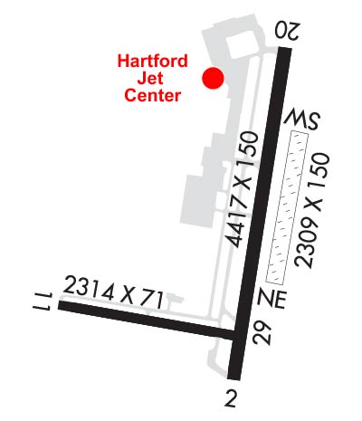
Runway Identification: 02/20Length: 4417 ft
Width: 150 ft
Surface: ASPHALT-FAIR CONDITION
Edge lights: High IntensityTreatment: GROOVED
| | Runway: 02 | | Runway: 20 |
| Mag heading: | 24° | Mag heading: | 204° |
| Rwy Slope: | .17% Up | Rwy Slope: | -.17% Down |
| Approach: | LDA | Approach: | |
| Pattern: | Left Traffic | Pattern: | Left Traffic |
| Markings: | NONPRECISION INSTRUMENT | Markings: | NONPRECISION INSTRUMENT |
| Marking Condition: | GOOD | Marking Condition: | GOOD |
| Arresting Dev: | | Arresting Dev: | |
| Lat & Long: | N4143.9 W07239.0 | Lat. & Long.: | N4144.6 W07238.8 |
| Elev: | 11.0 ft. MSL | Elev: | 18.3 ft. MSL |
| TCH: | 37 ft. AGL | TCH: | 58 ft. AGL |
| Visual Glide Path: | 3.50 degrees | Visual Glide Path: | 4.00 degrees |
| Displaced Threshold: | 411 feet | Displaced Threshold: | 560 feet |
| Touchdown Zone: | YES | Touchdown Zone: | YES |
| Touchdown Elev.: | 17.3 feet | Touchdown Elev.: | 17.8 feet |
| Visual Glide Slope: | 4-Light PAPI on LEFT side of Runway | Visual Glide Slope: | 4-Light PAPI on RIGHT side of Runway; RWY 20 PAPI UNUSBL BYD 7 DEGS L OF RCL. |
| RVR Equipment: | | RVR Equipment: | |
| RVV Equipment: | NO | RVV Equipment: | NO |
| Approach Lights: | | Approach Lights: | |
| REIL: | YES | REIL: | YES |
| Centerline Lights: | NO | Centerline Lights: | NO |
| Touchdown lights: | NO | Touchdown lights: | NO |
| Runway Category: | Runway with a Non-precision Approach having visibility minimums greater than 3/4 mile | Runway Category: | Runway with a Visual Approach |
| Declared Distances: | | Declared Distances: | |
| Obstructions: | TREES | Obstructions: | TREES |
| Marked: | NOT Marked/Lighted | Marked: | NOT Marked/Lighted |
| Clearance slope: | 10:1; APCH RATIO 20:1 TO DTHR. | Clearance slope: | 1:1; APCH RATIO 16:1 TO DTHR. |
| Obstruction height: | 100 feet AGL | Obstruction height: | 80 feet AGL |
| Dist. from runway: | 1263 feet | Dist. from runway: | 238 feet |
| Centerline offset: | 300 right of centerline | Centerline offset: | 252 feet right of centerline |
| Comments: | 3 FT GND, 0 FT DSTC, 150 FT R. | Comments: | 27 FT BERM, 0-199 FT DSTC, 171-57 FT L. |
Runway Identification: 11/29Length: 2314 ft
Width: 71 ft
Surface: ASPHALT-GOOD CONDITION
Edge lights: High IntensityTreatment: NONE
| | Runway: 11 | | Runway: 29 |
| Mag heading: | 114° | Mag heading: | 294° |
| Rwy Slope: | -.08% Down | Rwy Slope: | .08% Up |
| Approach: | | Approach: | |
| Pattern: | Left Traffic | Pattern: | Left Traffic |
| Markings: | BASIC | Markings: | BASIC |
| Marking Condition: | GOOD | Marking Condition: | GOOD |
| Arresting Dev: | | Arresting Dev: | |
| Lat & Long: | N4144.1 W07239.5 | Lat. & Long.: | N4144.0 W07239.0 |
| Elev: | 13.9 ft. MSL | Elev: | 12.0 ft. MSL |
| TCH: | | TCH: | |
| Visual Glide Path: | | Visual Glide Path: | |
| Displaced Threshold: | No | Displaced Threshold: | 265 feet |
| Touchdown Zone: | YES | Touchdown Zone: | YES |
| Touchdown Elev.: | 14.7 feet | Touchdown Elev.: | 14.7 feet |
| Visual Glide Slope: | | Visual Glide Slope: | |
| RVR Equipment: | | RVR Equipment: | |
| RVV Equipment: | NO | RVV Equipment: | NO |
| Approach Lights: | | Approach Lights: | |
| REIL: | NO | REIL: | NO |
| Centerline Lights: | NO | Centerline Lights: | NO |
| Touchdown lights: | NO | Touchdown lights: | NO |
| Runway Category: | Runway with a Visual Approach | Runway Category: | Runway with a Visual Approach |
| Declared Distances: | | Declared Distances: | |
| Obstructions: | TREES | Obstructions: | TREES |
| Marked: | NOT Marked/Lighted | Marked: | NOT Marked/Lighted |
| Clearance slope: | 6:1 | Clearance slope: | 5:1; APCH RATIO 11:1 TO DTHR. |
| Obstruction height: | 56 feet AGL | Obstruction height: | 88 feet AGL |
| Dist. from runway: | 550 feet | Dist. from runway: | 714 feet |
| Centerline offset: | 18 right of centerline | Centerline offset: | 175 feet right of centerline |
| Comments: | | Comments: | |
Runway Identification: H1 HELIPADLength: 70 ft
Width: 77 ft
Surface: ASPHALT-GOOD CONDITION
Edge lights: Medium Intensity
Treatment: NONE
Runway Identification: H2 HELIPADLength: 44 ft
Width: 44 ft
Surface: ASPHALT
Edge lights: Medium Intensity
Treatment: NONE
Runway Identification: NE/SWLength: 2309 ft
Width: 150 ft
Surface: GRASS
Edge lights: Treatment: NONE
| | Runway: NE | | Runway: SW |
| Mag heading: | N/A | Mag heading: | N/A |
| Approach: | | Approach: | |
| Pattern: | Left Traffic | Pattern: | Left Traffic |
| Markings: | | Markings: | |
| Marking Condition: | | Marking Condition: | |
| Arresting Dev: | | Arresting Dev: | |
| Lat & Long: | | Lat. & Long.: | |
| Elev: | N/A | Elev: | N/A |
| TCH: | | TCH: | |
| Visual Glide Path: | | Visual Glide Path: | |
| Displaced Threshold: | No | Displaced Threshold: | No |
| Touchdown Zone: | NO | Touchdown Zone: | NO |
| Touchdown Elev.: | | Touchdown Elev.: | |
| Visual Glide Slope: | | Visual Glide Slope: | |
| RVR Equipment: | | RVR Equipment: | |
| RVV Equipment: | NO | RVV Equipment: | NO |
| Approach Lights: | | Approach Lights: | |
| REIL: | NO | REIL: | NO |
| Centerline Lights: | NO | Centerline Lights: | NO |
| Touchdown lights: | NO | Touchdown lights: | NO |
| Runway Category: | Runway with a Visual Approach | Runway Category: | Runway with a Visual Approach |
| Declared Distances: | | Declared Distances: | |
| Obstructions: | TREES | Obstructions: | TREES |
| Marked: | NOT Marked/Lighted | Marked: | NOT Marked/Lighted |
| Clearance slope: | 9:1 | Clearance slope: | 20:1 |
| Obstruction height: | 68 feet AGL | Obstruction height: | 91 feet AGL |
| Dist. from runway: | 624 feet | Dist. from runway: | 1885 feet |
| Centerline offset: | 195 right of centerline | Centerline offset: | |
| Comments: | | Comments: | |