
| GORDONSVILLE MUNI GORDONSVILLE VA |
| |
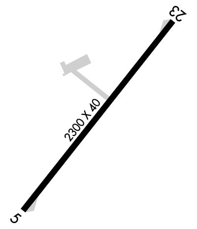
| Lat: N 3809.4 Long: W 07809.9 Elev: 452 Var: +10 Longest Runway: 2300 | ||
| AWOS: 120.22 CTAF: 123.0 | ||
| ||||||||||||||||||||||||||||||||
| ||||||||||||||||||||||||||||||||
| ||||||||||||||||||||||||||||||||
| Rwy | Rwy | |||||||
| 2300x50 | 2300' | 2300x50 | 2300' | |||||
| Runway ID | Single Wheel | Double Wheel | Double Tandem Wheel | Dual Double Wheel |
| 05/23 | 12,500 | N/A | N/A | N/A |
| These numbers are Advisory and are not limits. The Airport Manager should have more accurate Weight Limits | ||||
 Airport Diagram might not be current. | |
| Facility Name: | GORDONSVILLE MUNI |
| City Name: | GORDONSVILLE |
| County: | ORANGE |
| State abbrev: | VA |
| State Name: | VIRGINIA |
| Ownership: | PUBLICLY OWNED |
| Use: | OPEN TO THE PUBLIC |
| Owner's Name: | TOWN OF GORDONSVILLE |
| Address: | P.O. BOX 276 |
| GORDONSVILLE, VA 22942 | |
| Owner's Phone: | 540-832-2233 |
| Manager's Name: | DEBORAH S. KENDALL, TOWN MGR |
| Address: | PO BOX 276 |
| GORDONSVILLE, VA 22942 | |
| Phone: | (540) 832-2233 |
| FAA Region: | EASTERN |
| FAA Field Office: | DCA |
| Date | Sunrise | Sunset |
|---|---|---|
| 06/09/26 Tuesday | 5:49 | 20:35 |
| 06/10/26 Wednesday | 5:49 | 20:35 |
| 06/11/26 Thursday | 5:49 | 20:36 |
| 06/12/26 Friday | 5:49 | 20:36 |
| 06/13/26 Saturday | 5:49 | 20:36 |
| 06/14/26 Sunday | 5:49 | 20:37 |
| 06/15/26 Monday | 5:49 | 20:37 |
| 06/16/26 Tuesday | 5:49 | 20:38 |
| 06/17/26 Wednesday | 5:49 | 20:38 |
| 06/18/26 Thursday | 5:49 | 20:38 |
| 06/19/26 Friday | 5:49 | 20:39 |
| 06/20/26 Saturday | 5:50 | 20:39 |
| 06/21/26 Sunday | 5:50 | 20:39 |
| 06/22/26 Monday | 5:50 | 20:39 |
| Airport Attendance Schedule | 7 Days A Week UNATNDD |
| Airport Status | OPERATIONAL (This Status can change at any time - please check NOTAMS) |
| Airport Lighting Schedule | ACTVT MIRL RWY 05/23 - CTAF. |
| Airport Storage Available | Tie Downs |
| Extra Services Available | NONE |
| Wind Indicator | YES - (lighted) |
| Control Tower | NO |
| CTAF Frequency | 123.000 |
| Unicom Frequency | 123.000 |
| Rotating Beacon Color | WG |
| Segmented Circle | NO |
| Landing Fee | NO |
| Airport Inspected | STATE - performed by STATE AERONAUTICAL PERSONNEL |
| Inspection Date | 08/15/2023 |
| Type of Fuel Available | None |
| Airframe Repair Service | NONE |
| Power Plant Repair Service | NONE |
| Latitude | N3809.4 |
| Longitude | W07809.9 (ESTIMATED) |
| Arpt Elevation | 452ft (ESTIMATED) |
| Magnetic Variation | 10W |
| 2 miles NE | of GORDONSVILLE |
| Traffic Pattern Altitude | |
| Sectional Chart | WASHINGTON |
| Operations (Reported) | Yearly | Avg. Daily |
|---|---|---|
| General Aviation Transient | 0 | 0 |
| General Aviation Local | 0 | 0 |
| Air Taxi | 0 | 0 |
| Commerical | 0 | 0 |
| Commuter | 0 | 0 |
| Military | 0 | 0 |
| Aircraft based on Field | |
|---|---|
| General Aviation Singles | 0 |
| General Aviation Multi | 0 |
| Jet Aircraft | 0 |
| General Aviation Helicopters | 0 |
| Military Aircraft | 0 |
| Gliders | 0 |
| Ultralights | 0 |
| FSS on field | NO |
| FSS tie-in | LEESBURG |
| FSS Phone | 1-800-WX-BRIEF |
| Who issues Notams | DCA |
| Notam D service at airport | YES |
| ARTCC Name | WASHINGTON |
| Airport Certification | |
| Aircraft Rescue & Firefighting Index | None |
| Airport of Entry | No |
| Custom Landing Rights | No |
| Joint Civil/Military | No |
| Military Landing rights | No |
| FOR CD CTC POTOMAC APCH AT 866-640-4124. |
Airport Communications & Frequencies:
| |||||||||||||||||
| Runway: 05 | Runway: 23 | ||
| Mag heading: | 48° | Mag heading: | 228° |
| Rwy Slope: | -.23% Down | Rwy Slope: | .23% Up |
| Approach: | Approach: | ||
| Pattern: | Left Traffic | Pattern: | Left Traffic |
| Markings: | BASIC | Markings: | BASIC |
| Marking Condition: | GOOD | Marking Condition: | GOOD |
| Arresting Dev: | Arresting Dev: | ||
| Lat & Long: | N3809.2 W07810.1 | Lat. & Long.: | N3809.5 W07809.8 |
| Elev: | 451.8 ft. MSL | Elev: | 446.4 ft. MSL |
| TCH: | TCH: | ||
| Visual Glide Path: | Visual Glide Path: | ||
| Displaced Threshold: | No | Displaced Threshold: | No |
| Touchdown Zone: | YES | Touchdown Zone: | YES |
| Touchdown Elev.: | 451.8 feet | Touchdown Elev.: | 451.8 feet |
| Visual Glide Slope: | SYSTEM OF PANELS ON RIGHT SIDE OF RUNWAY (May NOT Be Lighted) | Visual Glide Slope: | SYSTEM OF PANELS ON RIGHT SIDE OF RUNWAY (May NOT Be Lighted) |
| RVR Equipment: | RVR Equipment: | ||
| RVV Equipment: | NO | RVV Equipment: | NO |
| Approach Lights: | Approach Lights: | ||
| REIL: | NO | REIL: | NO |
| Centerline Lights: | NO | Centerline Lights: | NO |
| Touchdown lights: | NO | Touchdown lights: | NO |
| Runway Category: | Runway with a Visual Approach | Runway Category: | Runway with a Visual Approach |
| Declared Distances: | Declared Distances: | ||
| Obstructions: | TREE | Obstructions: | TREE |
| Marked: | NOT Marked/Lighted | Marked: | NOT Marked/Lighted |
| Clearance slope: | 1:1 | Clearance slope: | 4:1 |
| Obstruction height: | 11 feet AGL | Obstruction height: | 77 feet AGL |
| Dist. from runway: | 217 feet | Dist. from runway: | 567 feet |
| Centerline offset: | 46 left of centerline | Centerline offset: | 130 feet right of centerline |
| Comments: | Comments: | LINE OF TREES 120 FT S OF RWY CNTRLN. |
Thanks for using FltPlan.com
all rights reserved © 1999-2026 by Flight Plan LLC
