
| GREAT BEND MUNI GREAT BEND KS |
| |
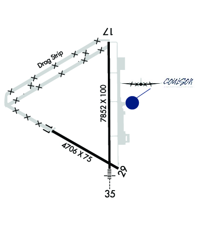
| Lat: N 3820.7 Long: W 09851.6 Elev: 1887 Var: -08 Longest Runway: 7852 | ||
| AWOS: 119.27 CTAF: 122.8 | ||
| ||||||
| ||||||
|
| Rwy | Rwy | |||||||
| 4706x75 | 4706' | 4706x75 | 4706' | |||||
| 7852x100 | 7852' | 7852x100 | 7852' | 111.90 - 351° | ||||
| Runway ID | Single Wheel | Double Wheel | Double Tandem Wheel | Dual Double Wheel |
| 11/29 | 28,000 | 35,000 | 86,000 | N/A |
| 17/35 | 28,000 | 35,000 | 86,000 | N/A |
| These numbers are Advisory and are not limits. The Airport Manager should have more accurate Weight Limits | ||||
 Airport Diagram might not be current. | |
| Facility Name: | GREAT BEND MUNI |
| City Name: | GREAT BEND |
| County: | BARTON |
| State abbrev: | KS |
| State Name: | KANSAS |
| Ownership: | PUBLICLY OWNED |
| Use: | OPEN TO THE PUBLIC |
| Owner's Name: | CITY OF GREAT BEND |
| Address: | CITY HALL, BOX 1168 |
| GREAT BEND, KS 67530 | |
| Owner's Phone: | 620-793-4111 |
| Manager's Name: | MR. MARTIN MILLER |
| Address: | CITY HALL, BOX 1168 |
| GREAT BEND, KS 67530 | |
| Phone: | 620-793-4168; AIRPORT MGR (620) 792-9446 (CELL). |
| FAA Region: | CENTRAL |
| FAA Field Office: | NONE |
| Date | Sunrise | Sunset |
|---|---|---|
| 09/24/21 Friday | 7:25 | 19:30 |
| 09/25/21 Saturday | 7:26 | 19:28 |
| 09/26/21 Sunday | 7:26 | 19:26 |
| 09/27/21 Monday | 7:27 | 19:25 |
| 09/28/21 Tuesday | 7:28 | 19:23 |
| 09/29/21 Wednesday | 7:29 | 19:22 |
| 09/30/21 Thursday | 7:30 | 19:20 |
| 10/01/21 Friday | 7:31 | 19:19 |
| 10/02/21 Saturday | 7:32 | 19:17 |
| 10/03/21 Sunday | 7:33 | 19:16 |
| 10/04/21 Monday | 7:34 | 19:14 |
| 10/05/21 Tuesday | 7:35 | 19:12 |
| 10/06/21 Wednesday | 7:36 | 19:11 |
| 10/07/21 Thursday | 7:37 | 19:09 |
| Airport Attendance Schedule | 7 Days A Week 0630-1800; AFTER 1800 BY REQUEST. |
| Airport Status | OPERATIONAL (This Status can change at any time - please check NOTAMS) |
| Airport Lighting Schedule | ACTVT MALSR RWY 35; REIL RWY 17; PAPI RWY 11, 17, 29 & 35; MIRL 11/29 & 17/35 - CTAF. |
| Airport Storage Available | Tie Downs, Hanger |
| Extra Services Available | Crop Dusting, Flight Instruction |
| Wind Indicator | YES - (lighted) |
| Control Tower | NO |
| CTAF Frequency | 122.800 |
| Unicom Frequency | 122.800 |
| Rotating Beacon Color | CLEAR-GREEN (Light Land Airport) |
| Segmented Circle | YES |
| Landing Fee | NO |
| Airport Inspected | FEDERAL - performed by STATE AERONAUTICAL PERSONNEL |
| Inspection Date | 07/27/2021 |
| Type of Fuel Available | Grade 100LL, JET A (freeze point -40C); -1024 HR CREDIT CARD SVC AVBL. |
| Airframe Repair Service | MAJOR |
| Power Plant Repair Service | MAJOR |
| Latitude | N3820.7 |
| Longitude | W09851.6 (ESTIMATED) |
| Arpt Elevation | 1886ft (SURVEYED) |
| Magnetic Variation | 08E |
| 4 miles W | of GREAT BEND |
| Traffic Pattern Altitude | |
| Sectional Chart | WICHITA |
| Operations (Reported) | Yearly | Avg. Daily |
|---|---|---|
| General Aviation Transient | 4512 | 12 |
| General Aviation Local | 8760 | 24 |
| Air Taxi | 1944 | 5 |
| Commerical | 0 | 0 |
| Commuter | 0 | 0 |
| Military | 360 | 1 |
| Aircraft based on Field | |
|---|---|
| General Aviation Singles | 27 |
| General Aviation Multi | 7 |
| Jet Aircraft | 2 |
| General Aviation Helicopters | 0 |
| Military Aircraft | 0 |
| Gliders | 1 |
| Ultralights | 0 |
| FSS on field | NO |
| FSS tie-in | WICHITA |
| FSS Phone | 1-800-WX-BRIEF |
| Who issues Notams | GBD |
| Notam D service at airport | YES |
| ARTCC Name | KANSAS CITY |
| Airport Certification | |
| Aircraft Rescue & Firefighting Index | None |
| Airport of Entry | No |
| Custom Landing Rights | No |
| Joint Civil/Military | No |
| Military Landing rights | YES |
| NATIONAL PLAN OF INTEGRATED AIRPORT SYSTEMS (NPIAS) |
| GRANT AGREEMENTS UNDER FAAP/ADAP/AIP |
| SURPLUS PROPERTY AGREEMENT UNDER PUBLIC LAW 289 |
| SURPLUS PROPERTY AGREEMENT UNDER REGULATION 16-WAA |
| ASSURANCES PURSUANT TO TITLE VI, CIVIL RIGHTS ACT OF 1964 |
| CALM WIND RY DESIGNATED AS RY 17. |
| 100LL AND JET A SELF-SERVE FUEL AVBL N END OF TRML APRON. CALL FBO 620-796-2130 FOR FUEL PRICES. |
| FOR CD IF UNA TO CTC ON FSS FREQ, CTC KANSAS CITY ARTCC AT 913-254-8508. |
Airport Communications & Frequencies:
| |||||||||
| Runway: 11 | Runway: 29 | ||
| Mag heading: | 112° | Mag heading: | 292° |
| Rwy Slope: | -.08% Down | Rwy Slope: | .08% Up |
| Approach: | Approach: | ||
| Pattern: | Left Traffic | Pattern: | Left Traffic |
| Markings: | NONPRECISION INSTRUMENT | Markings: | NONPRECISION INSTRUMENT |
| Marking Condition: | GOOD | Marking Condition: | GOOD |
| Arresting Dev: | Arresting Dev: | ||
| Lat & Long: | N3820.6 W09852.2 | Lat. & Long.: | N3820.2 W09851.3 |
| Elev: | 1886.7 ft. MSL | Elev: | 1882.7 ft. MSL |
| TCH: | 38 ft. AGL | TCH: | 43 ft. AGL |
| Visual Glide Path: | 3.00 degrees | Visual Glide Path: | 3.00 degrees |
| Displaced Threshold: | No | Displaced Threshold: | No |
| Touchdown Zone: | YES | Touchdown Zone: | YES |
| Touchdown Elev.: | 1886.7 feet | Touchdown Elev.: | 1884.4 feet |
| Visual Glide Slope: | 4-Light PAPI on LEFT side of Runway | Visual Glide Slope: | 4-Light PAPI on LEFT side of Runway |
| RVR Equipment: | RVR Equipment: | ||
| RVV Equipment: | NO | RVV Equipment: | NO |
| Approach Lights: | Approach Lights: | ||
| REIL: | NO | REIL: | NO |
| Centerline Lights: | NO | Centerline Lights: | NO |
| Touchdown lights: | NO | Touchdown lights: | NO |
| Runway Category: | Runway with a Visual Approach | Runway Category: | Runway with a Visual Approach |
| Declared Distances: | TORA:4706' TODA:4706' ASDA:4706' LDA:4706' | Declared Distances: | TORA:4706' TODA:4706' ASDA:4706' LDA:4706' |
| Runway: 17 | Runway: 35 | ||
| Mag heading: | 172° | Mag heading: | 352° |
| Rwy Slope: | .02% Up | Rwy Slope: | -.02% Down |
| Approach: | Approach: | ILS/DME | |
| Pattern: | Left Traffic | Pattern: | Left Traffic |
| Markings: | NONPRECISION INSTRUMENT | Markings: | PRECISION INSTRUMENT |
| Marking Condition: | GOOD | Marking Condition: | GOOD |
| Arresting Dev: | Arresting Dev: | ||
| Lat & Long: | N3821.5 W09851.4 | Lat. & Long.: | N3820.2 W09851.4 |
| Elev: | 1881.3 ft. MSL | Elev: | 1882.5 ft. MSL |
| TCH: | 38 ft. AGL | TCH: | 50 ft. AGL |
| Visual Glide Path: | 3.50 degrees | Visual Glide Path: | 3.00 degrees |
| Displaced Threshold: | No | Displaced Threshold: | No |
| Touchdown Zone: | YES | Touchdown Zone: | YES |
| Touchdown Elev.: | 1884.6 feet | Touchdown Elev.: | 1883.4 feet |
| Visual Glide Slope: | 4-Light PAPI on LEFT side of Runway | Visual Glide Slope: | 4-BOX VASI ON LEFT SIDE OF RUNWAY |
| RVR Equipment: | RVR Equipment: | ||
| RVV Equipment: | NO | RVV Equipment: | NO |
| Approach Lights: | Approach Lights: | MALSR - 1,400 foot medium intensity approach lighting system with runway alignment indicator lights | |
| REIL: | YES | REIL: | NO |
| Centerline Lights: | NO | Centerline Lights: | NO |
| Touchdown lights: | NO | Touchdown lights: | NO |
| Runway Category: | D | Runway Category: | Precision Instrument Runway |
| Declared Distances: | TORA:7852' TODA:7852' ASDA:7852' LDA:7852' | Declared Distances: | TORA:7852' TODA:7852' ASDA:7852' LDA:7852' |
Thanks for using FltPlan.com
all rights reserved © 1999-2021 by Flight Plan LLC
