
| SHANNON FREDERICKSBURG VA |
| |
| Lat: N 3816.0 Long: W 07727.0 Elev: 85 Var: +10 Longest Runway: 2999 | ||
| AWOS: 128.12 CTAF: 122.8 | ||
| ||||||||||||||||||||||||||||||||||||||||||||
| ||||||||||||||||||||||||||||||||||||||||||||
| ||||||||||||||||||||||||||||||||||||||||||||
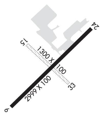
| Rwy | Rwy | |||||||
| 2999x100 | 2759' | 2999x100 | 2964' | |||||
| 1300x100 | 1300' | 1300x100 | 1300' | |||||
| Runway ID | Single Wheel | Double Wheel | Double Tandem Wheel | Dual Double Wheel |
| 06/24 | N/A | N/A | N/A | N/A |
| 15/33 | N/A | N/A | N/A | N/A |
| H1 | N/A | N/A | N/A | N/A |
| These numbers are Advisory and are not limits. The Airport Manager should have more accurate Weight Limits | ||||
 Airport Diagram might not be current. | |
| Facility Name: | SHANNON |
| City Name: | FREDERICKSBURG |
| County: | SPOTSYLVANIA |
| State abbrev: | VA |
| State Name: | VIRGINIA |
| Ownership: | PRIVATELY OWNED |
| Use: | OPEN TO THE PUBLIC |
| Owner's Name: | SHANNON AIRPORT LLC |
| Address: | 3380 SHANNON AIRPORT CIRCLE |
| FREDERICKSBURG, VA 22408 | |
| Owner's Phone: | 540-373-4431 |
| Manager's Name: | JOHN MCLANAHAN |
| Address: | 3380 SHANNON AIRPORT CIRCLE |
| FREDERICKSBURG, VA 22408 | |
| Phone: | 540-373-4431 |
| FAA Region: | EASTERN |
| FAA Field Office: | DCA |

| Date | Sunrise | Sunset |
|---|---|---|
| 09/24/21 Friday | 6:59 | 19:04 |
| 09/25/21 Saturday | 7:00 | 19:02 |
| 09/26/21 Sunday | 7:01 | 19:01 |
| 09/27/21 Monday | 7:02 | 18:59 |
| 09/28/21 Tuesday | 7:03 | 18:58 |
| 09/29/21 Wednesday | 7:03 | 18:56 |
| 09/30/21 Thursday | 7:04 | 18:55 |
| 10/01/21 Friday | 7:05 | 18:53 |
| 10/02/21 Saturday | 7:06 | 18:52 |
| 10/03/21 Sunday | 7:07 | 18:50 |
| 10/04/21 Monday | 7:08 | 18:48 |
| 10/05/21 Tuesday | 7:09 | 18:47 |
| 10/06/21 Wednesday | 7:10 | 18:45 |
| 10/07/21 Thursday | 7:11 | 18:44 |
| Airport Attendance Schedule | 7 Days A Week 0800-1700; UNATNDD NEW YEAR'S, EASTER, INDEPENDENCE, THANKSGIVING, & CHRISTMAS DAYS. |
| Airport Status | OPERATIONAL (This Status can change at any time - please check NOTAMS) |
| Airport Lighting Schedule | ACTVT MIRL RWY 06/24 - CTAF. |
| Airport Storage Available | Tie Downs, Hanger |
| Extra Services Available | Air Ambulance, Flight Instruction, Aircraft Rental |
| Wind Indicator | YES - (lighted) |
| Control Tower | NO |
| CTAF Frequency | 122.800 |
| Unicom Frequency | 122.800 |
| Rotating Beacon Color | CLEAR-GREEN (Light Land Airport) |
| Segmented Circle | NO |
| Landing Fee | NO |
| Airport Inspected | STATE - performed by STATE AERONAUTICAL PERSONNEL |
| Inspection Date | 05/17/2019 |
| Type of Fuel Available | Grade 100LL, JET A |
| Airframe Repair Service | MAJOR |
| Power Plant Repair Service | MAJOR |
| Latitude | N3816.0 |
| Longitude | W07727.0 (ESTIMATED) |
| Arpt Elevation | 85ft (SURVEYED) |
| Magnetic Variation | 10W |
| 2 miles S | of FREDERICKSBURG |
| Traffic Pattern Altitude | |
| Sectional Chart | WASHINGTON |
| Operations (Reported) | Yearly | Avg. Daily |
|---|---|---|
| General Aviation Transient | 4219 | 12 |
| General Aviation Local | 25312 | 69 |
| Air Taxi | 0 | 0 |
| Commerical | 0 | 0 |
| Commuter | 0 | 0 |
| Military | 176 | 0 |
| Aircraft based on Field | |
|---|---|
| General Aviation Singles | 85 |
| General Aviation Multi | 5 |
| Jet Aircraft | 0 |
| General Aviation Helicopters | 2 |
| Military Aircraft | 0 |
| Gliders | 1 |
| Ultralights | 2 |
| FSS on field | NO |
| FSS tie-in | LEESBURG |
| FSS Phone | 1-800-WX-BRIEF |
| Who issues Notams | EZF |
| Notam D service at airport | YES |
| ARTCC Name | WASHINGTON |
| Airport Certification | |
| Aircraft Rescue & Firefighting Index | None |
| Airport of Entry | No |
| Custom Landing Rights | No |
| Joint Civil/Military | No |
| Military Landing rights | YES |
| THIS AIRPORT HAS BEEN SURVEYED BY THE NATIONAL GEODETIC SURVEY. |
| RWY 15 CLD TO LDG AND TKOF. |
| CLEARANCE DELIVERY PHONE: GCO AVBL ON FREQ 135.075; QUANTICO CD DURING OP HRS - 6 CLICKS, POTOMAC CD ALL OTR TIMES - 4 CLICKS. IF UNA, FOR CD CTC QUANTICO CD DURING OP HOURS AT 703-784-5990, POTOMACH APCH ALL OTR TIMES AT 866-709-4993. |
| 24 HR SELF-SVC AVBL, FUEL TRUCK AVBL DURG OPR HRS. |
| 15 FT ROAD, 188 FT FM THLD, BOTH SIDES CNTRLN. |
| RWY 33 CLSD DLY SS-SR. |
| APCHS TO RWY 6/24 WILL BE MADE SUFLY HIGH TO CROSS RT. 2 (RWY 24) OR THE RAILROAD TRACKS (RWY 6) AT OR ABV 135 FT MSL (50 FT AGL). |
| TRAN ACFT PARK ON RAMP NE SIDE OF TRML. |
| REQ R/W ACFT NOT TAXI NEXT TO TRML. |
Airport Communications & Frequencies:
| |||||||||||||||||||||||||
| Runway: 06 | Runway: 24 | ||
| Mag heading: | 55° | Mag heading: | 235° |
| Rwy Slope: | .07% Up | Rwy Slope: | -.07% Down |
| Approach: | Approach: | ||
| Pattern: | Left Traffic | Pattern: | Left Traffic |
| Markings: | BASIC | Markings: | NONPRECISION INSTRUMENT |
| Marking Condition: | GOOD; FIRST 89 FT PAVEMENT RY 06 MARKED AS UNUSBL. | Marking Condition: | GOOD |
| Arresting Dev: | Arresting Dev: | ||
| Lat & Long: | N3815.8 W07727.2 | Lat. & Long.: | N3816.1 W07726.7 |
| Elev: | 83.0 ft. MSL | Elev: | 85.0 ft. MSL |
| TCH: | TCH: | ||
| Visual Glide Path: | Visual Glide Path: | ||
| Displaced Threshold: | 240 feet | Displaced Threshold: | 35 feet |
| Touchdown Zone: | YES | Touchdown Zone: | YES |
| Touchdown Elev.: | 85.0 feet | Touchdown Elev.: | 85.0 feet |
| Visual Glide Slope: | PULSATING/STEADY BURNING VASI ON LEFT SIDE OF RUNWAY; RWY 06 PVASI OTS INDEFLY. | Visual Glide Slope: | PULSATING/STEADY BURNING VASI ON LEFT SIDE OF RUNWAY |
| RVR Equipment: | RVR Equipment: | ||
| RVV Equipment: | NO | RVV Equipment: | NO |
| Approach Lights: | Approach Lights: | ||
| REIL: | NO | REIL: | NO |
| Centerline Lights: | NO | Centerline Lights: | NO |
| Touchdown lights: | NO | Touchdown lights: | NO |
| Runway Category: | Runway with a Visual Approach | Runway Category: | Runway with a Non-precision Approach |
| Declared Distances: | Declared Distances: | ||
| Obstructions: | RR | Obstructions: | TREE |
| Marked: | NOT Marked/Lighted | Marked: | NOT Marked/Lighted |
| Clearance slope: | RWY 06 +21 FT RR, DIST 348 FT, 16:1 BASED ON DSPLCD THLD. | Clearance slope: | 12:1; RWY 24, 12 FT ROAD, 206 FT, 2 FT L, 0:1 BASED ON DISPLCD THR. |
| Obstruction height: | 21 feet AGL | Obstruction height: | 22 feet AGL |
| Dist. from runway: | 205 feet | Dist. from runway: | 465 feet |
| Centerline offset: | Centerline offset: | 74 feet left of centerline | |
| Comments: | +20 FT TRR 180-200 FT FM RWY END 143 FT L TO 145 R. | Comments: | 12 FT ROAD 126 FT FM RWY END 2 FT L. |
| Runway: 15 | Runway: 33 | ||
| Mag heading: | 143° | Mag heading: | 323° |
| Approach: | Approach: | ||
| Pattern: | Left Traffic | Pattern: | Left Traffic |
| Markings: | Markings: | ||
| Marking Condition: | 15/33 OUTLINED WITH YELLOW CONES. | Marking Condition: | |
| Arresting Dev: | Arresting Dev: | ||
| Lat & Long: | Lat. & Long.: | ||
| Elev: | N/A | Elev: | N/A |
| TCH: | TCH: | ||
| Visual Glide Path: | Visual Glide Path: | ||
| Displaced Threshold: | No | Displaced Threshold: | No |
| Touchdown Zone: | NO | Touchdown Zone: | NO |
| Touchdown Elev.: | Touchdown Elev.: | ||
| Visual Glide Slope: | Visual Glide Slope: | ||
| RVR Equipment: | RVR Equipment: | ||
| RVV Equipment: | NO | RVV Equipment: | NO |
| Approach Lights: | Approach Lights: | ||
| REIL: | NO | REIL: | NO |
| Centerline Lights: | NO | Centerline Lights: | NO |
| Touchdown lights: | NO | Touchdown lights: | NO |
| Runway Category: | Runway with a Visual Approach | Runway Category: | Runway with a Visual Approach |
| Declared Distances: | Declared Distances: | ||
| Obstructions: | BRUSH | Obstructions: | |
| Marked: | NOT Marked/Lighted | Marked: | |
| Clearance slope: | 10:1; FROM RWY END | Clearance slope: | 50:1 |
| Obstruction height: | 29 feet AGL | Obstruction height: | |
| Dist. from runway: | 274 feet | Dist. from runway: | |
| Centerline offset: | 90 right of centerline | Centerline offset: | |
| Comments: | Comments: |
Thanks for using FltPlan.com
all rights reserved © 1999-2021 by Flight Plan LLC