
| BOWERS FIELD ELLENSBURG WA |
| |
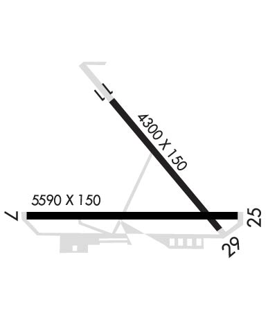
| Lat: N 4702.1 Long: W 12031.7 Elev: 1763 Var: -16 Longest Runway: 4300 | ||
| AWOS: 118.37 CTAF: 123.0 | ||
| ||||||||||||||||||||||||||||||||||||||||||||||||||||||||||||||||||||
| ||||||||||||||||||||||||||||||||||||||||||||||||||||||||||||||||||||
| ||||||||||||||||||||||||||||||||||||||||||||||||||||||||||||||||||||
| ||||||||||||||||||||||||||||||||||||||||||||||||||||||||||||||||||||
| Rwy | Rwy | |||||||
| 4300x150 | 4300' | 4300x150 | 4300' | |||||
| Runway ID | Single Wheel | Double Wheel | Double Tandem Wheel | Dual Double Wheel |
| 11/29 | 35,000 | 57,000 | 100,000 | N/A |
| These numbers are Advisory and are not limits. The Airport Manager should have more accurate Weight Limits | ||||
 Airport Diagram might not be current. | |
| Facility Name: | BOWERS FLD |
| City Name: | ELLENSBURG |
| County: | KITTITAS |
| State abbrev: | WA |
| State Name: | WASHINGTON |
| Ownership: | PUBLICLY OWNED |
| Use: | OPEN TO THE PUBLIC |
| Owner's Name: | KITTITAS COUNTY |
| Address: | 205 WEST 5TH AVE., SUITE 105 |
| ELLENSBURG, WA 98926 | |
| Owner's Phone: | 509-962-7523 |
| Manager's Name: | JOSHUA FREDRICKSON |
| Address: | 411 N. RUBY ST, SUITE #1 |
| ELLENSBURG, WA 98926 | |
| Phone: | 509-962-7523 |
| FAA Region: | NORTHWEST MOUNTAIN |
| FAA Field Office: | SEA |
| Date | Sunrise | Sunset |
|---|---|---|
| 06/07/26 Sunday | 5:08 | 20:54 |
| 06/08/26 Monday | 5:08 | 20:55 |
| 06/09/26 Tuesday | 5:07 | 20:56 |
| 06/10/26 Wednesday | 5:07 | 20:56 |
| 06/11/26 Thursday | 5:07 | 20:57 |
| 06/12/26 Friday | 5:07 | 20:58 |
| 06/13/26 Saturday | 5:06 | 20:58 |
| 06/14/26 Sunday | 5:06 | 20:59 |
| 06/15/26 Monday | 5:06 | 20:59 |
| 06/16/26 Tuesday | 5:06 | 20:59 |
| 06/17/26 Wednesday | 5:06 | 21:00 |
| 06/18/26 Thursday | 5:06 | 21:00 |
| 06/19/26 Friday | 5:06 | 21:00 |
| 06/20/26 Saturday | 5:07 | 21:01 |
| Airport Attendance Schedule | MON-FRI 0700-1600 |
| Airport Status | OPERATIONAL (This Status can change at any time - please check NOTAMS) |
| Airport Lighting Schedule | ACTVT MIRLS RWY 11/29; PAPI RWY 29 - CTAF. |
| Airport Storage Available | Tie Downs |
| Extra Services Available | Charter, Flight Instruction |
| Wind Indicator | YES - (lighted) |
| Control Tower | NO |
| CTAF Frequency | 123.000 |
| Unicom Frequency | 123.000 |
| Rotating Beacon Color | WG |
| Segmented Circle | YES |
| Landing Fee | NO |
| Airport Inspected | STATE - performed by STATE AERONAUTICAL PERSONNEL |
| Inspection Date | 08/21/2024 |
| Type of Fuel Available | Grade 100LL, JET A (freeze point -40C) |
| Airframe Repair Service | MAJOR |
| Power Plant Repair Service | MAJOR |
| Latitude | N4702.1 |
| Longitude | W12031.7 (ESTIMATED) |
| Arpt Elevation | 1763ft (SURVEYED) |
| Magnetic Variation | 16E |
| 2 miles N | of ELLENSBURG |
| Traffic Pattern Altitude | 834 |
| Sectional Chart | SEATTLE |
| Operations (Reported) | Yearly | Avg. Daily |
|---|---|---|
| General Aviation Transient | 0 | 0 |
| General Aviation Local | 0 | 0 |
| Air Taxi | 0 | 0 |
| Commerical | 0 | 0 |
| Commuter | 0 | 0 |
| Military | 0 | 0 |
| Aircraft based on Field | |
|---|---|
| General Aviation Singles | 0 |
| General Aviation Multi | 0 |
| Jet Aircraft | 0 |
| General Aviation Helicopters | 0 |
| Military Aircraft | 0 |
| Gliders | 0 |
| Ultralights | 0 |
| FSS on field | NO |
| FSS tie-in | SEATTLE |
| FSS Phone | 1-800-WX-BRIEF |
| Who issues Notams | ELN |
| Notam D service at airport | YES |
| ARTCC Name | SEATTLE |
| Airport Certification | |
| Aircraft Rescue & Firefighting Index | None |
| Airport of Entry | No |
| Custom Landing Rights | No |
| Joint Civil/Military | No |
| Military Landing rights | YES |
| NATIONAL PLAN OF INTEGRATED AIRPORT SYSTEMS (NPIAS) |
| GRANT AGREEMENTS UNDER FAAP/ADAP/AIP |
| SURPLUS PROPERTY AGREEMENT UNDER PUBLIC LAW 289 |
| ASSURANCES PURSUANT TO TITLE VI, CIVIL RIGHTS ACT OF 1964 |
| AGREEMENT UNDER DLAND OR DCLA HAS EXPIRED. |
| TWY ALPHA, CHARLIE, ECHO CLSD. |
| FOR CD IF UNA TO CTC ON FSS FREQ, CTC SEATTLE ARTCC AT 253-351-3694. |
| DSTC TO GO MKRS NORTH SIDE OF RWY 11/29. |
| 100LL AND JET A SELF SVC AVBL WITH CREDIT CARD. FS JET A AVBL UPON REQ. |
| EXTENSIVE FLIGHT TRAINING AT OR BELOW 7500 FT' WITHIN 10 NM OF ELN (MONITOR 123.0) |
| RWY 11/2 9 HAS 1460 FT STOPWAY NW END. |
Airport Communications & Frequencies:
| |||||||||
| Runway: 11 | Runway: 29 | ||
| Mag heading: | 117° | Mag heading: | 297° |
| Rwy Slope: | -.38% Down | Rwy Slope: | .38% Up |
| Approach: | Approach: | ||
| Pattern: | Left Traffic | Pattern: | Left Traffic |
| Markings: | BASIC | Markings: | BASIC |
| Marking Condition: | FAIR | Marking Condition: | FAIR |
| Arresting Dev: | Arresting Dev: | ||
| Lat & Long: | N4702.3 W12032.1 | Lat. & Long.: | N4701.8 W12031.4 |
| Elev: | 1763.2 ft. MSL | Elev: | 1747.0 ft. MSL |
| TCH: | TCH: | 40 ft. AGL | |
| Visual Glide Path: | Visual Glide Path: | 3.00 degrees | |
| Displaced Threshold: | No | Displaced Threshold: | No |
| Touchdown Zone: | YES | Touchdown Zone: | YES |
| Touchdown Elev.: | 1763.2 feet | Touchdown Elev.: | 1758.9 feet |
| Visual Glide Slope: | Visual Glide Slope: | 4-Light PAPI on RIGHT side of Runway | |
| RVR Equipment: | RVR Equipment: | ||
| RVV Equipment: | NO | RVV Equipment: | NO |
| Approach Lights: | Approach Lights: | ||
| REIL: | NO | REIL: | NO |
| Centerline Lights: | NO | Centerline Lights: | NO |
| Touchdown lights: | NO | Touchdown lights: | NO |
| Runway Category: | Runway with a Visual Approach | Runway Category: | Runway with a Non-precision Approach having visibility minimums greater than 3/4 mile |
| Declared Distances: | Declared Distances: |
Thanks for using FltPlan.com
all rights reserved © 1999-2026 by Flight Plan LLC


