
| ELMIRA/CORNING RGNL ELMIRA/CORNING NY |
| |
| Lat: N 4209.6 Long: W 07653.5 Elev: 955 Var: +12 Longest Runway: 8001 | ||
| Clr Del: 121.9 Dept. ATIS: 125.47 Arr. ATIS: 125.47 AWOS: 125.47 Ground: 121.9 Tower: 121.1 | ||
| ||||||||||||||||||||||||||||||||||||||||||||||||||||||||||||||||||||
| ||||||||||||||||||||||||||||||||||||||||||||||||||||||||||||||||||||
| ||||||||||||||||||||||||||||||||||||||||||||||||||||||||||||||||||||
| ||||||||||||||||||||||||||||||||||||||||||||||||||||||||||||||||||||
| Rwy | Rwy | |||||||
| 2016x150 | 2016' | 2016x150 | 2016' | |||||
| 8001x150 | 7401' | 109.10 - 062° | 8001x150 | 7799' | 109.10 - 242° | |||
| 5404x150 | 5404' | 5404x150 | 5002' | |||||
| Runway ID | Single Wheel | Double Wheel | Double Tandem Wheel | Dual Double Wheel |
| 05/23 | N/A | N/A | N/A | N/A |
| 06/24 | 80,000 | 121,000 | 200,000 | N/A |
| 10/28 | 57,000 | 90,000 | 150,000 | N/A |
| These numbers are Advisory and are not limits. The Airport Manager should have more accurate Weight Limits | ||||
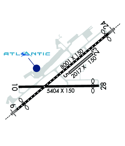 Airport Diagram might not be current. | |
| Facility Name: | ELMIRA/CORNING RGNL |
| City Name: | ELMIRA/CORNING |
| County: | CHEMUNG |
| State abbrev: | NY |
| State Name: | NEW YORK |
| Ownership: | PUBLICLY OWNED |
| Use: | OPEN TO THE PUBLIC |
| Owner's Name: | COUNTY OF CHEMUNG |
| Address: | 276 SING SING RD., SUITE 1 |
| HORSEHEADS, NY 14845 | |
| Owner's Phone: | 607-739-5621; OR 607-739-5622. |
| Manager's Name: | THOMAS FREEMAN |
| Address: | 276 SING SING RD.,SUITE 1 |
| HORSEHEADS, NY 14845 | |
| Phone: | 607-739-5621 |
| FAA Region: | EASTERN |
| FAA Field Office: | NYC |
| Date | Sunrise | Sunset |
|---|---|---|
| 06/08/26 Monday | 5:32 | 20:42 |
| 06/09/26 Tuesday | 5:31 | 20:42 |
| 06/10/26 Wednesday | 5:31 | 20:43 |
| 06/11/26 Thursday | 5:31 | 20:43 |
| 06/12/26 Friday | 5:31 | 20:44 |
| 06/13/26 Saturday | 5:31 | 20:44 |
| 06/14/26 Sunday | 5:31 | 20:45 |
| 06/15/26 Monday | 5:31 | 20:45 |
| 06/16/26 Tuesday | 5:31 | 20:46 |
| 06/17/26 Wednesday | 5:31 | 20:46 |
| 06/18/26 Thursday | 5:31 | 20:46 |
| 06/19/26 Friday | 5:31 | 20:47 |
| 06/20/26 Saturday | 5:31 | 20:47 |
| 06/21/26 Sunday | 5:31 | 20:47 |
| Airport Attendance Schedule | CONTINUOUS |
| Airport Status | OPERATIONAL (This Status can change at any time - please check NOTAMS) |
| Airport Lighting Schedule | WHEN ATCT CLSD ACTVT MALSR RWY 06 & 24; HIRL RWY 06/24; MIRL RWY 10/28; TWY LGTS - CTAF. |
| Airport Storage Available | Tie Downs, Hanger |
| Extra Services Available | Cargo Handling, Charter, Flight Instruction, Aircraft Rental, Aircraft Sales |
| Wind Indicator | YES - (lighted) |
| Control Tower | YES |
| CTAF Frequency | 121.100 |
| Unicom Frequency | 122.950 |
| Rotating Beacon Color | WG |
| Segmented Circle | NO |
| Landing Fee | YES; LNDG FEE FOR ALL NON BASED ACFT. |
| Airport Inspected | FEDERAL - performed by FAA AIRPORTS FIELD PERSONNEL |
| Inspection Date | 04/14/2026 |
| Type of Fuel Available | Grade 100LL, JET A (freeze point -40C) |
| Airframe Repair Service | MAJOR |
| Power Plant Repair Service | MAJOR |
| Latitude | N4209.6 |
| Longitude | W07653.5 (ESTIMATED) |
| Arpt Elevation | 955ft (SURVEYED) |
| Magnetic Variation | 12W |
| 6 miles NW | of ELMIRA/CORNING |
| Traffic Pattern Altitude | 1545; TPA: 1545 FT AGL RECIPROCATING ENG, 2045 FT AGL TURBOPROP/JET. |
| Sectional Chart | NEW YORK |
| Operations (Reported) | Yearly | Avg. Daily |
|---|---|---|
| General Aviation Transient | 0 | 0 |
| General Aviation Local | 0 | 0 |
| Air Taxi | 0 | 0 |
| Commerical | 0 | 0 |
| Commuter | 0 | 0 |
| Military | 0 | 0 |
| Aircraft based on Field | |
|---|---|
| General Aviation Singles | 0 |
| General Aviation Multi | 0 |
| Jet Aircraft | 0 |
| General Aviation Helicopters | 0 |
| Military Aircraft | 0 |
| Gliders | 0 |
| Ultralights | 0 |
| FSS on field | NO |
| FSS tie-in | BUFFALO |
| FSS Phone | 1-800-WX-BRIEF |
| Who issues Notams | ELM |
| Notam D service at airport | YES |
| ARTCC Name | NEW YORK |
| Airport Certification | AIRPORT RECEIVING SCHEDULED AIR CARRIER SERVICE FROM CARRIERS CERTIFICATED BY THE CIVIL AERONAUTICS BOARD; ARFF INDEX C EQUIPMENT COVERAGE IS AVBL UPON REQUEST CTC ARPT MANAGEMENT AT 607-426-5621. |
| Aircraft Rescue & Firefighting Index | AIRPORT HAS A CERTIFICATE UNDER CFR PART 139 |
| Airport of Entry | No |
| Custom Landing Rights | No |
| Joint Civil/Military | No |
| Military Landing rights | YES |
| NATIONAL PLAN OF INTEGRATED AIRPORT SYSTEMS (NPIAS) |
| GRANT AGREEMENTS UNDER FAAP/ADAP/AIP |
| ASSURANCES PURSUANT TO TITLE VI, CIVIL RIGHTS ACT OF 1964 |
| AGREEMENT UNDER DLAND OR DCLA HAS EXPIRED. |
| ACFT WITH WINGSPANS GTR THAN 93 FEET SHOULD USE EXTREME CARE WHEN TAXIING ON TWY T ADJ TO APRONS. |
| RWY 10 OPNS PROHIBITED FOR ACFT WITH APCH SPEEDS GTR THAN OR EQUAL TO 121 KNOTS AND/OR WINGSPANS GTR THAN OR EQUAL TO 118 FT . |
| COLD TEMPERATURE AIRPORT. ALTITUDE CORRECTION REQUIRED AT OR BELOW -21C. |
| TWY H, J, & L LTD TO DESIGN GROUP II ACFT. |
| TRML RAMP IS UNCONTROLLED. DO NOT CALL FOR PUSH/POWER BACK. ADVISE GC WHEN READY TO TAXI FOR DEP. |
| TWY T BTN TXY L AND TWY D NONMOVEMENT AREA. |
| FOR CD IF UNA TO CTC ON FSS FREQ, CTC NEW YORK ARTCC AT 631-468-1425. |
| EXTSV GLIDER ACT ON & INVOF ARPT. |
| BIRDS & DEER ON & INVOF ARPT. |
| RWY 05/23 (SOUTHEAST OF RWY 06/24) UNMARKED SEASONAL USE TURF RWY CLSD 1 DEC THROUGH 30 APR. |
| FOR LAND SIDE ACCESS FM APRON WHEN FBO CLSD CTC ELM ARPT ATTENDANT AT 607-426-5621. |
| WINTER DE-ICING ON GLYCOL APRON ONLY. |
| BLIMP ACT RQRS PPR, CTC ARPT MGMT AT 607-426-5621. |
| RWY 06/2 4 PCR VALUE: 560/F/B/X/T |
| RWY 10/2 8 PCR VALUE: 640/F/B/X/T |
Airport Communications & Frequencies:
| |||||||||||||||||||||||||||||||||||
| Runway: 05 | Runway: 23 | ||
| Mag heading: | 62° | Mag heading: | 242° |
| Rwy Slope: | .00% Up | Rwy Slope: | .00% Down |
| Approach: | Approach: | ||
| Pattern: | Left Traffic | Pattern: | Left Traffic |
| Markings: | Markings: | ||
| Marking Condition: | RWY 05/23 MKD WITH ASPH L CORNER MARKERS. | Marking Condition: | |
| Arresting Dev: | Arresting Dev: | ||
| Lat & Long: | N4209.6 W07653.4 | Lat. & Long.: | N4209.8 W07653.1 |
| Elev: | 943.5 ft. MSL | Elev: | 943.6 ft. MSL |
| TCH: | TCH: | ||
| Visual Glide Path: | Visual Glide Path: | ||
| Displaced Threshold: | No | Displaced Threshold: | No |
| Touchdown Zone: | YES | Touchdown Zone: | YES |
| Touchdown Elev.: | 944.4 feet | Touchdown Elev.: | 944.4 feet |
| Visual Glide Slope: | Visual Glide Slope: | ||
| RVR Equipment: | RVR Equipment: | ||
| RVV Equipment: | NO | RVV Equipment: | NO |
| Approach Lights: | Approach Lights: | ||
| REIL: | NO | REIL: | NO |
| Centerline Lights: | NO | Centerline Lights: | NO |
| Touchdown lights: | NO | Touchdown lights: | NO |
| Runway Category: | Runway with a Visual Approach | Runway Category: | Runway with a Visual Approach |
| Declared Distances: | TORA:2017' TODA:2017' ASDA:2017' LDA:2017' | Declared Distances: | TORA:2017' TODA:2017' ASDA:2017' LDA:2017' |
| Runway: 06 | Runway: 24 | ||
| Mag heading: | 62° | Mag heading: | 242° |
| Rwy Slope: | .15% Up | Rwy Slope: | -.15% Down |
| Approach: | ILS | Approach: | ILS |
| Pattern: | Left Traffic | Pattern: | Left Traffic |
| Markings: | PRECISION INSTRUMENT | Markings: | PRECISION INSTRUMENT |
| Marking Condition: | GOOD | Marking Condition: | GOOD |
| Arresting Dev: | EMAS; ENGINEERED MATERIALS ARRESTING SYSTEM (EMAS) 259 FT IN LENGTH BY 170 FT IN WIDTH LCTD AT DER 06. | Arresting Dev: | |
| Lat & Long: | N4209.2 W07654.2 | Lat. & Long.: | N4210.1 W07652.8 |
| Elev: | 942.8 ft. MSL | Elev: | 955.0 ft. MSL |
| TCH: | 51 ft. AGL | TCH: | 52 ft. AGL |
| Visual Glide Path: | 3.00 degrees | Visual Glide Path: | 3.00 degrees |
| Displaced Threshold: | 600 feet | Displaced Threshold: | 202 feet |
| Touchdown Zone: | YES | Touchdown Zone: | YES |
| Touchdown Elev.: | 943.7 feet | Touchdown Elev.: | 954.8 feet |
| Visual Glide Slope: | 4-BOX VASI ON LEFT SIDE OF RUNWAY | Visual Glide Slope: | 4-Light PAPI on LEFT side of Runway; PAPI UNUSBL BYD 9 DEGS RIGHT OF CNTRLN. |
| RVR Equipment: | TOUCHDOWN-MIDFIELD-ROLLOUT | RVR Equipment: | TOUCHDOWN-MIDFIELD-ROLLOUT |
| RVV Equipment: | NO | RVV Equipment: | NO |
| Approach Lights: | MALSR - 1,400 foot medium intensity approach lighting system with runway alignment indicator lights | Approach Lights: | MALSR - 1,400 foot medium intensity approach lighting system with runway alignment indicator lights |
| REIL: | NO | REIL: | NO |
| Centerline Lights: | YES | Centerline Lights: | YES |
| Touchdown lights: | NO | Touchdown lights: | NO |
| Runway Category: | Precision Instrument Runway | Runway Category: | Precision Instrument Runway |
| Declared Distances: | TORA:8001' TODA:8001' ASDA:8001' LDA:7401' | Declared Distances: | TORA:8001' TODA:8001' ASDA:8001' LDA:7799' |
| Obstructions: | TREE | Obstructions: | TREE |
| Marked: | NOT Marked/Lighted | Marked: | NOT Marked/Lighted |
| Clearance slope: | 34:1 | Clearance slope: | 31:1 |
| Obstruction height: | 790 feet AGL | Obstruction height: | 382 feet AGL |
| Dist. from runway: | 27250 feet | Dist. from runway: | 12329 feet |
| Centerline offset: | 1800 right of centerline | Centerline offset: | 2123 feet right of centerline |
| Comments: | Comments: |
| Runway: 10 | Runway: 28 | ||
| Mag heading: | 101° | Mag heading: | 281° |
| Rwy Slope: | .19% Up | Rwy Slope: | -.19% Down |
| Approach: | Approach: | ||
| Pattern: | Left Traffic | Pattern: | Left Traffic |
| Markings: | NONPRECISION INSTRUMENT | Markings: | NONPRECISION INSTRUMENT |
| Marking Condition: | GOOD | Marking Condition: | GOOD |
| Arresting Dev: | Arresting Dev: | ||
| Lat & Long: | N4209.5 W07654.2 | Lat. & Long.: | N4209.5 W07653.0 |
| Elev: | 934.3 ft. MSL | Elev: | 944.4 ft. MSL |
| TCH: | TCH: | 40 ft. AGL | |
| Visual Glide Path: | Visual Glide Path: | 3.00 degrees | |
| Displaced Threshold: | No | Displaced Threshold: | 402 feet |
| Touchdown Zone: | YES | Touchdown Zone: | YES |
| Touchdown Elev.: | 941.6 feet | Touchdown Elev.: | 943.7 feet |
| Visual Glide Slope: | Visual Glide Slope: | 4-Light PAPI on LEFT side of Runway | |
| RVR Equipment: | RVR Equipment: | ||
| RVV Equipment: | NO | RVV Equipment: | NO |
| Approach Lights: | Approach Lights: | ||
| REIL: | NO | REIL: | NO |
| Centerline Lights: | NO | Centerline Lights: | NO |
| Touchdown lights: | NO | Touchdown lights: | NO |
| Runway Category: | Runway with a Non-precision Approach having visibility minimums greater than 3/4 mile | Runway Category: | Runway with a Non-precision Approach having visibility minimums greater than 3/4 mile |
| Declared Distances: | TORA:5404' TODA:5404' ASDA:5004' LDA:5004' | Declared Distances: | TORA:5404' TODA:5404' ASDA:5404' LDA:5002' |
| Obstructions: | TREES | Obstructions: | POLE |
| Marked: | NOT Marked/Lighted | Marked: | NOT Marked/Lighted |
| Clearance slope: | 13:1 | Clearance slope: | 21:1 |
| Obstruction height: | 632 feet AGL | Obstruction height: | 54 feet AGL |
| Dist. from runway: | 8761 feet | Dist. from runway: | 1351 feet |
| Centerline offset: | 1488 left of centerline | Centerline offset: | 264 feet left of centerline |
| Comments: | Comments: |
Thanks for using FltPlan.com
all rights reserved © 1999-2026 by Flight Plan LLC


