
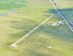
| MONDELL FIELD NEWCASTLE WY |
| |
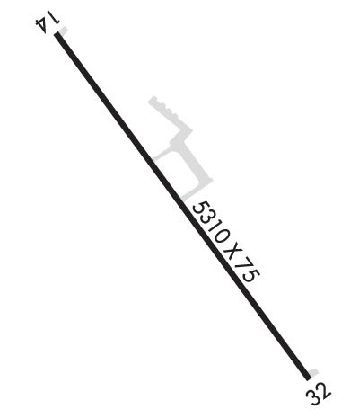
| Lat: N 4353.1 Long: W 10418.9 Elev: 4178 Var: -08 Longest Runway: 5310 | ||
| AWOS: 118.0 CTAF: 122.8 | ||
| ||||||||||||||||||||||||||||||||||||||||||||
| ||||||||||||||||||||||||||||||||||||||||||||
| ||||||||||||||||||||||||||||||||||||||||||||
| Rwy | Rwy | |||||||
| 5310x75 | 5310' | 5310x75 | 5310' | |||||
| Runway ID | Single Wheel | Double Wheel | Double Tandem Wheel | Dual Double Wheel |
| 14/32 | 30,000 | N/A | N/A | N/A |
| These numbers are Advisory and are not limits. The Airport Manager should have more accurate Weight Limits | ||||
 Airport Diagram might not be current. | |
| Facility Name: | MONDELL FLD |
| City Name: | NEWCASTLE |
| County: | WESTON |
| State abbrev: | WY |
| State Name: | WYOMING |
| Ownership: | PUBLICLY OWNED |
| Use: | OPEN TO THE PUBLIC |
| Owner's Name: | CITY OF NEWCASTLE/WESTON CO |
| Address: | COUNTY COURT HOUSE/1 W MAIN |
| NEWCASTLE, WY 82701 | |
| Owner's Phone: | 307-746-4744; PHONE NUMBER FOR CITY 307-746-3535 |
| Manager's Name: | BYRAND STREETER |
| Address: | PO BOX 699 |
| NEWCASTLE, WY 82701 | |
| Phone: | 307-746-4666 |
| FAA Region: | NORTHWEST MOUNTAIN |
| FAA Field Office: | DEN |
| Date | Sunrise | Sunset |
|---|---|---|
| 09/24/21 Friday | 6:46 | 18:51 |
| 09/25/21 Saturday | 6:48 | 18:49 |
| 09/26/21 Sunday | 6:49 | 18:48 |
| 09/27/21 Monday | 6:50 | 18:46 |
| 09/28/21 Tuesday | 6:51 | 18:44 |
| 09/29/21 Wednesday | 6:52 | 18:42 |
| 09/30/21 Thursday | 6:53 | 18:40 |
| 10/01/21 Friday | 6:55 | 18:38 |
| 10/02/21 Saturday | 6:56 | 18:37 |
| 10/03/21 Sunday | 6:57 | 18:35 |
| 10/04/21 Monday | 6:58 | 18:33 |
| 10/05/21 Tuesday | 6:59 | 18:31 |
| 10/06/21 Wednesday | 7:01 | 18:29 |
| 10/07/21 Thursday | 7:02 | 18:28 |
| Airport Attendance Schedule | MON-SAT 0800-1700; UNATNDD MAJOR HOLS - CALL AFT HRS ON THESE DAYS. |
| Airport Status | OPERATIONAL (This Status can change at any time - please check NOTAMS) |
| Airport Lighting Schedule | ACTVT ODALS RWY 32; REIL RWY 14; PAPI RWY 14 & 32; MIRL RWY 14/32 - CTAF. |
| Airport Storage Available | Tie Downs, Hanger |
| Extra Services Available | Flight Instruction |
| Wind Indicator | YES - (lighted) |
| Control Tower | NO |
| CTAF Frequency | 122.800 |
| Unicom Frequency | 122.800 |
| Rotating Beacon Color | CLEAR-GREEN (Light Land Airport) |
| Segmented Circle | YES |
| Landing Fee | NO |
| Airport Inspected | STATE - performed by STATE AERONAUTICAL PERSONNEL |
| Inspection Date | 09/17/2020 |
| Type of Fuel Available | Grade 100LL, JET A (freeze point -40C); -10FOR FUEL AFT HRS PHONE 307-746-5805. |
| Airframe Repair Service | None |
| Power Plant Repair Service | None |
| Latitude | N4353.1 |
| Longitude | W10418.9 (ESTIMATED) |
| Arpt Elevation | 4177ft (SURVEYED) |
| Magnetic Variation | 08E |
| 5 miles NW | of NEWCASTLE |
| Traffic Pattern Altitude | |
| Sectional Chart | CHEYENNE |
| Operations (Reported) | Yearly | Avg. Daily |
|---|---|---|
| General Aviation Transient | 2600 | 7 |
| General Aviation Local | 2100 | 6 |
| Air Taxi | 85 | 0 |
| Commerical | 0 | 0 |
| Commuter | 0 | 0 |
| Military | 20 | 0 |
| Aircraft based on Field | |
|---|---|
| General Aviation Singles | 13 |
| General Aviation Multi | 0 |
| Jet Aircraft | 0 |
| General Aviation Helicopters | 1 |
| Military Aircraft | 0 |
| Gliders | 0 |
| Ultralights | 0 |
| FSS on field | NO |
| FSS tie-in | CASPER |
| FSS Phone | 1-800-WX-BRIEF |
| Who issues Notams | CPR |
| Notam D service at airport | YES |
| ARTCC Name | DENVER |
| Airport Certification | |
| Aircraft Rescue & Firefighting Index | None |
| Airport of Entry | No |
| Custom Landing Rights | No |
| Joint Civil/Military | No |
| Military Landing rights | YES |
| NATIONAL PLAN OF INTEGRATED AIRPORT SYSTEMS (NPIAS) |
| GRANT AGREEMENTS UNDER FAAP/ADAP/AIP |
| ASSURANCES PURSUANT TO TITLE VI, CIVIL RIGHTS ACT OF 1964 |
| WILDLIFE ON OR NEAR THE RWYS. MIGRATORY BIRD FLT PATHS NEAR ARPT. |
| SOFT SHOULDERS NEAR EDGES OF RWYS, TWYS, & RAMPS. |
| FOR CD IF UNA TO CTC ON FSS FREQ, CTC DENVER ARTCC AT 303-651-4257. |
| HIGH VOL OF ACFT OPRNG INVOF OF MT RUSHMORE AND CRAZY HORSE MONUMENTS AT OR BLW 7500 FT; PILOTS ARE ADVISED TO MNT 122.85 FOR TFC ADVISORIES. |
Airport Communications & Frequencies:
| |||||||||
| Runway: 14 | Runway: 32 | ||
| Mag heading: | 136° | Mag heading: | 316° |
| Rwy Slope: | .17% Up | Rwy Slope: | -.17% Down |
| Approach: | Approach: | ||
| Pattern: | Right Traffic | Pattern: | Left Traffic |
| Markings: | NONPRECISION INSTRUMENT | Markings: | NONPRECISION INSTRUMENT |
| Marking Condition: | GOOD | Marking Condition: | FAIR |
| Arresting Dev: | Arresting Dev: | ||
| Lat & Long: | N4353.4 W10419.2 | Lat. & Long.: | N4352.7 W10418.5 |
| Elev: | 4168.7 ft. MSL | Elev: | 4177.5 ft. MSL |
| TCH: | 43 ft. AGL | TCH: | 45 ft. AGL |
| Visual Glide Path: | 3.00 degrees | Visual Glide Path: | 3.00 degrees |
| Displaced Threshold: | No | Displaced Threshold: | No |
| Touchdown Zone: | YES | Touchdown Zone: | YES |
| Touchdown Elev.: | 4168.9 feet | Touchdown Elev.: | 4177.5 feet |
| Visual Glide Slope: | 2-Light PAPI on LEFT side of Runway | Visual Glide Slope: | 2-Light PAPI on LEFT side of Runway |
| RVR Equipment: | RVR Equipment: | ||
| RVV Equipment: | NO | RVV Equipment: | NO |
| Approach Lights: | Approach Lights: | ODALS - omnidirectional approach lighting system | |
| REIL: | YES | REIL: | NO |
| Centerline Lights: | NO | Centerline Lights: | NO |
| Touchdown lights: | NO | Touchdown lights: | NO |
| Runway Category: | Runway with a Non-precision Approach having visibility minimums greater than 3/4 mile | Runway Category: | Runway with a Non-precision Approach having visibility minimums greater than 3/4 mile |
| Declared Distances: | Declared Distances: | ||
| Obstructions: | RR | Obstructions: | |
| Marked: | NOT Marked/Lighted | Marked: | |
| Clearance slope: | 27:1 | Clearance slope: | 34:1 |
| Obstruction height: | 38 feet AGL | Obstruction height: | |
| Dist. from runway: | 1184 feet | Dist. from runway: | |
| Centerline offset: | 125 left of centerline | Centerline offset: | |
| Comments: | Comments: |
Thanks for using FltPlan.com
all rights reserved © 1999-2021 by Flight Plan LLC