
| CONVERSE COUNTY DOUGLAS WY |
| |
| Lat: N 4247.8 Long: W 10523.2 Elev: 4933 Var: -11 Longest Runway: 6534 | ||
| AWOS: 135.22 CTAF: 122.8 | ||
| ||||||||||||||||||||||||||||||||||||||||||||
| ||||||||||||||||||||||||||||||||||||||||||||
| ||||||||||||||||||||||||||||||||||||||||||||
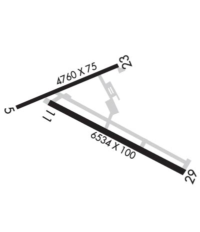
| Rwy | Rwy | |||||||
| 4760x75 | 4760' | 4760x75 | 4760' | |||||
| 6534x100 | 6534' | 6534x100 | 6534' | |||||
| Runway ID | Single Wheel | Double Wheel | Double Tandem Wheel | Dual Double Wheel |
| 05/23 | 12,500 | N/A | N/A | N/A |
| 11/29 | N/A | N/A | N/A | N/A |
| These numbers are Advisory and are not limits. The Airport Manager should have more accurate Weight Limits | ||||
 Airport Diagram might not be current. | |
| Facility Name: | CONVERSE COUNTY |
| City Name: | DOUGLAS |
| County: | CONVERSE |
| State abbrev: | WY |
| State Name: | WYOMING |
| Ownership: | PUBLICLY OWNED |
| Use: | OPEN TO THE PUBLIC |
| Owner's Name: | CONVERSE COUNTY |
| Address: | PO BOX 774 |
| DOUGLAS, WY 82633 | |
| Owner's Phone: | 307-358-4924 |
| Manager's Name: | STEVE GOOD |
| Address: | P O BOX 774 |
| DOUGLAS, WY 82633 | |
| Phone: | 307-358-4924 |
| FAA Region: | NORTHWEST MOUNTAIN |
| FAA Field Office: | DEN |
| Date | Sunrise | Sunset |
|---|---|---|
| 06/12/26 Friday | 5:23 | 20:40 |
| 06/13/26 Saturday | 5:23 | 20:41 |
| 06/14/26 Sunday | 5:22 | 20:41 |
| 06/15/26 Monday | 5:22 | 20:42 |
| 06/16/26 Tuesday | 5:22 | 20:42 |
| 06/17/26 Wednesday | 5:23 | 20:42 |
| 06/18/26 Thursday | 5:23 | 20:43 |
| 06/19/26 Friday | 5:23 | 20:43 |
| 06/20/26 Saturday | 5:23 | 20:43 |
| 06/21/26 Sunday | 5:23 | 20:43 |
| 06/22/26 Monday | 5:23 | 20:44 |
| 06/23/26 Tuesday | 5:24 | 20:44 |
| 06/24/26 Wednesday | 5:24 | 20:44 |
| 06/25/26 Thursday | 5:24 | 20:44 |
| Airport Attendance Schedule | MON-FRI 0630-1700, SAT-SUN 0800-1700 |
| Airport Status | OPERATIONAL (This Status can change at any time - please check NOTAMS) |
| Airport Lighting Schedule | ACTVT REIL RWYS 11 AND 29; MIRL RWY 05/23 &11/29 DALGT HRS - 122.8. MIRL RWY 05/23 & 11/29 PRESET TO LOW INTST DARK HRS, TO INCR INTST - 122.8. PAPI RWY 11, 23 & 29 OPR CONSLY. |
| Airport Storage Available | Tie Downs, Hanger |
| Extra Services Available | NONE |
| Wind Indicator | YES - (lighted) |
| Control Tower | NO |
| CTAF Frequency | 122.800 |
| Unicom Frequency | 122.800 |
| Rotating Beacon Color | WG |
| Segmented Circle | YES |
| Landing Fee | NO |
| Airport Inspected | STATE - performed by STATE AERONAUTICAL PERSONNEL |
| Inspection Date | 08/04/2023 |
| Type of Fuel Available | Grade 100LL, JET A (freeze point -40C); -10FUEL AFT HRS SEE PHONE NRS POSTED IN TRML LOBBY. CALL OUT FEE WILL APPLY. |
| Airframe Repair Service | MAJOR |
| Power Plant Repair Service | MAJOR |
| Latitude | N4247.8 |
| Longitude | W10523.2 (ESTIMATED) |
| Arpt Elevation | 4932ft (SURVEYED) |
| Magnetic Variation | 11E |
| 3 miles N | of DOUGLAS |
| Traffic Pattern Altitude | |
| Sectional Chart | CHEYENNE |
| Operations (Reported) | Yearly | Avg. Daily |
|---|---|---|
| General Aviation Transient | 0 | 0 |
| General Aviation Local | 0 | 0 |
| Air Taxi | 0 | 0 |
| Commerical | 0 | 0 |
| Commuter | 0 | 0 |
| Military | 0 | 0 |
| Aircraft based on Field | |
|---|---|
| General Aviation Singles | 0 |
| General Aviation Multi | 0 |
| Jet Aircraft | 0 |
| General Aviation Helicopters | 0 |
| Military Aircraft | 0 |
| Gliders | 0 |
| Ultralights | 0 |
| FSS on field | NO |
| FSS tie-in | CASPER |
| FSS Phone | 1-800-WX-BRIEF |
| Who issues Notams | DGW |
| Notam D service at airport | YES |
| ARTCC Name | DENVER |
| Airport Certification | |
| Aircraft Rescue & Firefighting Index | None |
| Airport of Entry | No |
| Custom Landing Rights | No |
| Joint Civil/Military | No |
| Military Landing rights | YES |
| NATIONAL PLAN OF INTEGRATED AIRPORT SYSTEMS (NPIAS) |
| GRANT AGREEMENTS UNDER FAAP/ADAP/AIP |
| ASSURANCES PURSUANT TO TITLE VI, CIVIL RIGHTS ACT OF 1964 |
| WILDLIFE ON & INVOF ARPT. |
| RETRO-REFLECTIVE MKRS ALG ALL TWYS. |
| FOR CD IF UNA TO CTC ON FSS FREQ, CTC DENVER ARTCC AT 303-651-4257. |
| RWY 05/2 3 ASPH REMOVED & CONVERTED TO A TREATED BASE SFC 2019. |
Airport Communications & Frequencies:
| |||||||||
| Runway: 05 | Runway: 23 | ||
| Mag heading: | 56° | Mag heading: | 236° |
| Rwy Slope: | .26% Up | Rwy Slope: | -.26% Down |
| Approach: | Approach: | ||
| Pattern: | Left Traffic | Pattern: | Left Traffic |
| Markings: | Markings: | ||
| Marking Condition: | Marking Condition: | ||
| Arresting Dev: | Arresting Dev: | ||
| Lat & Long: | N4247.9 W10523.9 | Lat. & Long.: | N4248.2 W10522.9 |
| Elev: | 4901.6 ft. MSL | Elev: | 4913.8 ft. MSL |
| TCH: | TCH: | 45 ft. AGL | |
| Visual Glide Path: | Visual Glide Path: | 3.00 degrees | |
| Displaced Threshold: | No | Displaced Threshold: | No |
| Touchdown Zone: | YES | Touchdown Zone: | YES |
| Touchdown Elev.: | 4910.6 feet | Touchdown Elev.: | 4913.8 feet |
| Visual Glide Slope: | Visual Glide Slope: | 2-Light PAPI on LEFT side of Runway | |
| RVR Equipment: | RVR Equipment: | ||
| RVV Equipment: | NO | RVV Equipment: | NO |
| Approach Lights: | Approach Lights: | ||
| REIL: | NO | REIL: | NO |
| Centerline Lights: | NO | Centerline Lights: | NO |
| Touchdown lights: | NO | Touchdown lights: | NO |
| Runway Category: | Runway with a Visual Approach | Runway Category: | Runway with a Visual Approach |
| Declared Distances: | Declared Distances: | ||
| Obstructions: | Obstructions: | HILL | |
| Marked: | Marked: | NOT Marked/Lighted | |
| Clearance slope: | 50:1 | Clearance slope: | 23:1 |
| Obstruction height: | Obstruction height: | 116 feet AGL | |
| Dist. from runway: | Dist. from runway: | 2925 feet | |
| Centerline offset: | Centerline offset: | 175 feet right of centerline | |
| Comments: | Comments: |
| Runway: 11 | Runway: 29 | ||
| Mag heading: | 107° | Mag heading: | 287° |
| Rwy Slope: | .35% Up | Rwy Slope: | -.35% Down |
| Approach: | Approach: | ||
| Pattern: | Left Traffic | Pattern: | Left Traffic |
| Markings: | NONPRECISION INSTRUMENT | Markings: | NONPRECISION INSTRUMENT |
| Marking Condition: | GOOD | Marking Condition: | GOOD |
| Arresting Dev: | Arresting Dev: | ||
| Lat & Long: | N4247.9 W10523.6 | Lat. & Long.: | N4247.4 W10522.3 |
| Elev: | 4909.6 ft. MSL | Elev: | 4932.7 ft. MSL |
| TCH: | 33 ft. AGL | TCH: | 45 ft. AGL |
| Visual Glide Path: | 3.00 degrees | Visual Glide Path: | 3.00 degrees |
| Displaced Threshold: | No | Displaced Threshold: | No |
| Touchdown Zone: | YES | Touchdown Zone: | YES |
| Touchdown Elev.: | 4920.6 feet | Touchdown Elev.: | 4932.7 feet |
| Visual Glide Slope: | 2-Light PAPI on LEFT side of Runway | Visual Glide Slope: | 2-Light PAPI on LEFT side of Runway |
| RVR Equipment: | RVR Equipment: | ||
| RVV Equipment: | NO | RVV Equipment: | NO |
| Approach Lights: | Approach Lights: | ||
| REIL: | YES | REIL: | YES |
| Centerline Lights: | NO | Centerline Lights: | NO |
| Touchdown lights: | NO | Touchdown lights: | NO |
| Runway Category: | D | Runway Category: | D |
| Declared Distances: | Declared Distances: |
Thanks for using FltPlan.com
all rights reserved © 1999-2026 by Flight Plan LLC
