
| CUSTER COUNTY CUSTER SD |
| |
| Lat: N 4344.0 Long: W 10337.2 Elev: 5620 Var: -11 Longest Runway: 5500 | ||
| AWOS: 120.0 CTAF: 122.8 | ||
| ||||||
| ||||||
|
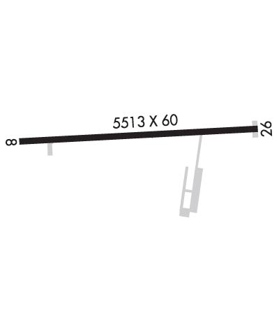
| Rwy | Rwy | |||||||
| 5500x60 | 5500' | 5500x60 | 5500' | |||||
| Runway ID | Single Wheel | Double Wheel | Double Tandem Wheel | Dual Double Wheel |
| 08/26 | 12,500 | N/A | N/A | N/A |
| These numbers are Advisory and are not limits. The Airport Manager should have more accurate Weight Limits | ||||
| FltPlan does not have IFR approach charts available for KCUT. |
 Airport Diagram might not be current. | |
| Facility Name: | CUSTER COUNTY |
| City Name: | CUSTER |
| County: | CUSTER |
| State abbrev: | SD |
| State Name: | SOUTH DAKOTA |
| Ownership: | PUBLICLY OWNED |
| Use: | OPEN TO THE PUBLIC |
| Owner's Name: | CUSTER COUNTY |
| Address: | 420 MT RUSHMORE RD |
| CUSTER, SD 57730 | |
| Owner's Phone: | 605-673-4824 |
| Manager's Name: | BRENDEN HENDRICKSON; MGR CELL NUMBER 605-858-1246. |
| Address: | 12220 AVIATION WAY |
| CUSTER, SD 57730 | |
| Phone: | 605-673-3874 |
| FAA Region: | GREAT LAKES |
| FAA Field Office: | DMA |

| Date | Sunrise | Sunset |
|---|---|---|
| 09/24/21 Friday | 6:44 | 18:49 |
| 09/25/21 Saturday | 6:45 | 18:47 |
| 09/26/21 Sunday | 6:46 | 18:45 |
| 09/27/21 Monday | 6:47 | 18:43 |
| 09/28/21 Tuesday | 6:48 | 18:41 |
| 09/29/21 Wednesday | 6:49 | 18:39 |
| 09/30/21 Thursday | 6:51 | 18:38 |
| 10/01/21 Friday | 6:52 | 18:36 |
| 10/02/21 Saturday | 6:53 | 18:34 |
| 10/03/21 Sunday | 6:54 | 18:32 |
| 10/04/21 Monday | 6:55 | 18:30 |
| 10/05/21 Tuesday | 6:56 | 18:29 |
| 10/06/21 Wednesday | 6:58 | 18:27 |
| 10/07/21 Thursday | 6:59 | 18:25 |
| Airport Attendance Schedule | MON-FRI 1500-0000 |
| Airport Status | OPERATIONAL (This Status can change at any time - please check NOTAMS) |
| Airport Lighting Schedule | ACTVT MIRL RWY 08/26; PAPI RWY 08 & 26 - CTAF. |
| Airport Storage Available | Tie Downs, Hanger |
| Extra Services Available | Air Ambulance, Flight Instruction, Aircraft Rental |
| Wind Indicator | YES - (lighted) |
| Control Tower | NO |
| CTAF Frequency | 122.800 |
| Unicom Frequency | 122.800 |
| Rotating Beacon Color | CLEAR-GREEN (Light Land Airport); ARPT BCN OBSC RDLS 200-260. |
| Segmented Circle | YES |
| Landing Fee | NO |
| Airport Inspected | STATE - performed by STATE AERONAUTICAL PERSONNEL |
| Inspection Date | 07/27/2021 |
| Type of Fuel Available | Grade 100LL, JET A (freeze point -40C) |
| Airframe Repair Service | NONE |
| Power Plant Repair Service | NONE |
| Latitude | N4344.0 |
| Longitude | W10337.2 (ESTIMATED) |
| Arpt Elevation | 5619ft (SURVEYED) |
| Magnetic Variation | 11E |
| 2 miles SW | of CUSTER |
| Traffic Pattern Altitude | |
| Sectional Chart | CHEYENNE |
| Operations (Reported) | Yearly | Avg. Daily |
|---|---|---|
| General Aviation Transient | 500 | 1 |
| General Aviation Local | 3200 | 9 |
| Air Taxi | 0 | 0 |
| Commerical | 0 | 0 |
| Commuter | 0 | 0 |
| Military | 500 | 1 |
| Aircraft based on Field | |
|---|---|
| General Aviation Singles | 15 |
| General Aviation Multi | 0 |
| Jet Aircraft | 0 |
| General Aviation Helicopters | 2 |
| Military Aircraft | 0 |
| Gliders | 0 |
| Ultralights | 0 |
| FSS on field | NO |
| FSS tie-in | HURON |
| FSS Phone | 1-800-WX-BRIEF |
| Who issues Notams | CUT |
| Notam D service at airport | YES |
| ARTCC Name | DENVER |
| Airport Certification | |
| Aircraft Rescue & Firefighting Index | None |
| Airport of Entry | No |
| Custom Landing Rights | No |
| Joint Civil/Military | No |
| Military Landing rights | YES |
| NATIONAL PLAN OF INTEGRATED AIRPORT SYSTEMS (NPIAS) |
| GRANT AGREEMENTS UNDER FAAP/ADAP/AIP |
| ASSURANCES PURSUANT TO TITLE VI, CIVIL RIGHTS ACT OF 1964 |
| STRONG CROSSWINDS & WINDSHEAR MAY EXIST ON FINAL UNDER WINDY CONDS. |
| CFM WINTER CONDS WITH AMGR 605-858-1246. |
| BE ALERT: CHECK DENSITY ALT & LEAN MIXTURE FOR BEST OPERATION AT THIS ALT. |
| 10 FT WILDLIFE FENCE AROUND PERIMETER OF AIRPORT. |
| FUEL AVBL 24 HR WITH CREDIT CARD. |
| FOR CD CTC ELLSWORTH APCH AT 605-385-6198, WHEN APCH CLSD CTC DENVER ARTCC AT 303-651-4257. |
| HIGH VOL OF ACFT OPRNG INVOF OF MT RUSHMORE AND CRAZY HORSE MONUMENTS AT OR BLW 7500 FT; PILOTS ARE ADVISED TO MNT 122.85 FOR TFC ADVISORIES. |
| Runway: 08 | Runway: 26 | ||
| Mag heading: | 76° | Mag heading: | 256° |
| Rwy Slope: | -1.28% Down | Rwy Slope: | 1.28% Up |
| Approach: | Approach: | ||
| Pattern: | Left Traffic | Pattern: | Left Traffic |
| Markings: | NONPRECISION INSTRUMENT | Markings: | NONPRECISION INSTRUMENT |
| Marking Condition: | GOOD | Marking Condition: | GOOD |
| Arresting Dev: | Arresting Dev: | ||
| Lat & Long: | N4344.0 W10337.8 | Lat. & Long.: | N4344.0 W10336.5 |
| Elev: | 5619.7 ft. MSL | Elev: | 5549.1 ft. MSL |
| TCH: | 40 ft. AGL | TCH: | 48 ft. AGL |
| Visual Glide Path: | 3.00 degrees | Visual Glide Path: | 3.65 degrees |
| Displaced Threshold: | No | Displaced Threshold: | No |
| Touchdown Zone: | YES | Touchdown Zone: | YES |
| Touchdown Elev.: | 5619.7 feet | Touchdown Elev.: | 5585.3 feet |
| Visual Glide Slope: | 4-Light PAPI on LEFT side of Runway | Visual Glide Slope: | 4-Light PAPI on LEFT side of Runway |
| RVR Equipment: | RVR Equipment: | ||
| RVV Equipment: | NO | RVV Equipment: | NO |
| Approach Lights: | Approach Lights: | ||
| REIL: | NO | REIL: | NO |
| Centerline Lights: | NO | Centerline Lights: | NO |
| Touchdown lights: | NO | Touchdown lights: | NO |
| Runway Category: | Runway with a Visual Approach | Runway Category: | Runway with a Visual Approach |
| Declared Distances: | Declared Distances: | ||
| Obstructions: | Obstructions: | TREES | |
| Marked: | Marked: | NOT Marked/Lighted | |
| Clearance slope: | 50:1 | Clearance slope: | 21:1 |
| Obstruction height: | Obstruction height: | 60 feet AGL | |
| Dist. from runway: | Dist. from runway: | 1500 feet | |
| Centerline offset: | Centerline offset: | ||
| Comments: | Comments: |
Thanks for using FltPlan.com
all rights reserved © 1999-2021 by Flight Plan LLC