
| CONCORD MUNI CONCORD NH |
| |
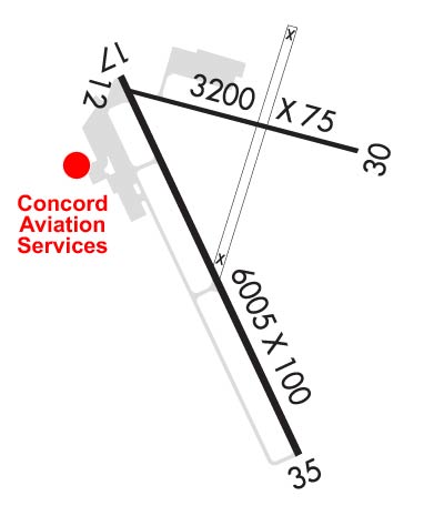
| Lat: N 4312.2 Long: W 07130.1 Elev: 342 Var: +16 Longest Runway: 6005 | ||
| Clr Del: 133.65 AWOS: 132.32 CTAF: 122.7 | ||
| ||||||||||||||||||||||||||||||||||||||||||||
| ||||||||||||||||||||||||||||||||||||||||||||
| ||||||||||||||||||||||||||||||||||||||||||||
| Rwy | Rwy | |||||||
| 3200x75 | 3200' | 3200x75 | 3200' | |||||
| 6005x100 | 5364' | 6005x100 | 6005' | 108.70 - 351° | ||||
| Runway ID | Single Wheel | Double Wheel | Double Tandem Wheel | Dual Double Wheel |
| 12/30 | 30,000 | N/A | N/A | N/A |
| 17/35 | 43,000 | 60,000 | N/A | N/A |
| These numbers are Advisory and are not limits. The Airport Manager should have more accurate Weight Limits | ||||
 Airport Diagram might not be current. | |
| Facility Name: | CONCORD MUNI |
| City Name: | CONCORD |
| County: | MERRIMACK |
| State abbrev: | NH |
| State Name: | NEW HAMPSHIRE |
| Ownership: | PUBLICLY OWNED |
| Use: | OPEN TO THE PUBLIC |
| Owner's Name: | CITY OF CONCORD |
| Address: | 41 GREEN ST; CITY MANAGER'S OFFICE. |
| CONCORD, NH 03301 | |
| Owner's Phone: | 603-225-8570 |
| Manager's Name: | DAVID ROLLA |
| Address: | 71 AIRPORT ROAD |
| CONCORD, NH 03301 | |
| Phone: | 603-228-2267 |
| FAA Region: | NEW ENGLAND |
| FAA Field Office: | NONE |
| Date | Sunrise | Sunset |
|---|---|---|
| 09/24/21 Friday | 6:35 | 18:40 |
| 09/25/21 Saturday | 6:36 | 18:38 |
| 09/26/21 Sunday | 6:37 | 18:37 |
| 09/27/21 Monday | 6:39 | 18:35 |
| 09/28/21 Tuesday | 6:40 | 18:33 |
| 09/29/21 Wednesday | 6:41 | 18:31 |
| 09/30/21 Thursday | 6:42 | 18:29 |
| 10/01/21 Friday | 6:43 | 18:28 |
| 10/02/21 Saturday | 6:44 | 18:26 |
| 10/03/21 Sunday | 6:45 | 18:24 |
| 10/04/21 Monday | 6:46 | 18:22 |
| 10/05/21 Tuesday | 6:48 | 18:21 |
| 10/06/21 Wednesday | 6:49 | 18:19 |
| 10/07/21 Thursday | 6:50 | 18:17 |
| Airport Attendance Schedule | 7 Days A Week 0700-1700; EXC THANKSGIVING, CHRISTMAS, & NEW YEARS DAY. |
| Airport Status | OPERATIONAL (This Status can change at any time - please check NOTAMS) |
| Airport Lighting Schedule | ACTVT MALSR RWY 35; HIRL RWY 17/35; MIRL RWY 12/30 - CTAF. |
| Airport Storage Available | Tie Downs, Hanger |
| Extra Services Available | Avionics, Flight Instruction, Aircraft Rental, Aircraft Sales |
| Wind Indicator | YES - (lighted) |
| Control Tower | NO |
| CTAF Frequency | 122.700 |
| Unicom Frequency | 122.700 |
| Rotating Beacon Color | CLEAR-GREEN (Light Land Airport) |
| Segmented Circle | NO |
| Landing Fee | NO |
| Airport Inspected | STATE - performed by STATE AERONAUTICAL PERSONNEL |
| Inspection Date | 12/15/2020 |
| Type of Fuel Available | Grade 100LL, JET A (freeze point -40C); -10SELF-SERVE 100LL AVBL 24 HRS WITH CREDIT CARD. FOR JET A AFT HRS CALL 1-603-228-2267 AND FLW PROMPTS. |
| Airframe Repair Service | MAJOR |
| Power Plant Repair Service | MAJOR |
| Latitude | N4312.2 |
| Longitude | W07130.1 (ESTIMATED) |
| Arpt Elevation | 341ft (SURVEYED) |
| Magnetic Variation | 16W |
| 2 miles E | of CONCORD |
| Traffic Pattern Altitude | |
| Sectional Chart | NEW YORK |
| Operations (Reported) | Yearly | Avg. Daily |
|---|---|---|
| General Aviation Transient | 15000 | 41 |
| General Aviation Local | 9000 | 25 |
| Air Taxi | 2000 | 5 |
| Commerical | 0 | 0 |
| Commuter | 0 | 0 |
| Military | 6200 | 17 |
| Aircraft based on Field | |
|---|---|
| General Aviation Singles | 74 |
| General Aviation Multi | 1 |
| Jet Aircraft | 0 |
| General Aviation Helicopters | 3 |
| Military Aircraft | 10 |
| Gliders | 5 |
| Ultralights | 1 |
| FSS on field | NO |
| FSS tie-in | BANGOR |
| FSS Phone | 1-800-WX-BRIEF |
| Who issues Notams | CON |
| Notam D service at airport | YES |
| ARTCC Name | BOSTON |
| Airport Certification | |
| Aircraft Rescue & Firefighting Index | None |
| Airport of Entry | No |
| Custom Landing Rights | No |
| Joint Civil/Military | No |
| Military Landing rights | YES |
| NATIONAL PLAN OF INTEGRATED AIRPORT SYSTEMS (NPIAS) |
| GRANT AGREEMENTS UNDER FAAP/ADAP/AIP |
| ASSURANCES PURSUANT TO TITLE VI, CIVIL RIGHTS ACT OF 1964 |
| AGREEMENT UNDER DLAND OR DCLA HAS EXPIRED. |
| THIS AIRPORT HAS BEEN SURVEYED BY THE NATIONAL GEODETIC SURVEY. |
| WILDLIFE ON & INVOF ARPT. |
| COMPASS ROSE CALIBRATED 2014. |
| FOR CD CTC BOSTON APCH AT 603-594-5552. |
| OPNS ON NG TWY & RAMP PROHIBITED WO PRIOR CDN DUE TO SCTY. |
| DAY & NIGHT VFR HEL OPNS TO & FM NEW HAMPSHIRE STATE POLICE HNGR. |
| OPNS OFF PAVED SFCS PROHIBITED DUE TO CONSERVATION MGMT ACTS. |
| RWY 35 DSGND CALM WIND RWY. |
| MIL TWY AND RAMP PCN R/A/W/T. |
| HVY HEL ACT 1 NM ESE OF ARPT 800 FT AND BLW. |
Airport Communications & Frequencies:
| ||||||||||||||||||
| Runway: 12 | Runway: 30 | ||
| Mag heading: | 121° | Mag heading: | 301° |
| Rwy Slope: | .06% Up | Rwy Slope: | -.06% Down |
| Approach: | Approach: | ||
| Pattern: | Left Traffic | Pattern: | Left Traffic |
| Markings: | NONPRECISION INSTRUMENT | Markings: | NONPRECISION INSTRUMENT |
| Marking Condition: | GOOD | Marking Condition: | GOOD |
| Arresting Dev: | Arresting Dev: | ||
| Lat & Long: | N4312.5 W07130.4 | Lat. & Long.: | N4312.3 W07129.7 |
| Elev: | 339.8 ft. MSL | Elev: | 341.7 ft. MSL |
| TCH: | 52 ft. AGL | TCH: | |
| Visual Glide Path: | 3.32 degrees | Visual Glide Path: | |
| Displaced Threshold: | No | Displaced Threshold: | No |
| Touchdown Zone: | YES | Touchdown Zone: | YES |
| Touchdown Elev.: | 341.7 feet | Touchdown Elev.: | 341.7 feet |
| Visual Glide Slope: | 2-Light PAPI on LEFT side of Runway | Visual Glide Slope: | |
| RVR Equipment: | RVR Equipment: | ||
| RVV Equipment: | NO | RVV Equipment: | NO |
| Approach Lights: | Approach Lights: | ||
| REIL: | NO | REIL: | NO |
| Centerline Lights: | NO | Centerline Lights: | NO |
| Touchdown lights: | NO | Touchdown lights: | NO |
| Runway Category: | Runway with a Non-precision Approach having visibility minimums greater than 3/4 mile | Runway Category: | Runway with a Visual Approach |
| Declared Distances: | Declared Distances: | ||
| Obstructions: | TREES | Obstructions: | TREES |
| Marked: | NOT Marked/Lighted | Marked: | NOT Marked/Lighted |
| Clearance slope: | 19:1 | Clearance slope: | 9:1 |
| Obstruction height: | 87 feet AGL | Obstruction height: | 5 feet AGL |
| Dist. from runway: | 1862 feet | Dist. from runway: | 249 feet |
| Centerline offset: | 228 right of centerline | Centerline offset: | 110 feet left of centerline |
| Comments: | Comments: |
| Runway: 17 | Runway: 35 | ||
| Mag heading: | 171° | Mag heading: | 351° |
| Rwy Slope: | -.15% Down | Rwy Slope: | .15% Up |
| Approach: | Approach: | ILS | |
| Pattern: | Left Traffic | Pattern: | Left Traffic |
| Markings: | NONPRECISION INSTRUMENT | Markings: | PRECISION INSTRUMENT |
| Marking Condition: | GOOD | Marking Condition: | GOOD |
| Arresting Dev: | Arresting Dev: | ||
| Lat & Long: | N4312.5 W07130.5 | Lat. & Long.: | N4311.6 W07129.9 |
| Elev: | 340.6 ft. MSL | Elev: | 331.4 ft. MSL |
| TCH: | 50 ft. AGL | TCH: | 50 ft. AGL |
| Visual Glide Path: | 3.00 degrees | Visual Glide Path: | 3.00 degrees |
| Displaced Threshold: | 641 feet | Displaced Threshold: | No |
| Touchdown Zone: | YES | Touchdown Zone: | YES |
| Touchdown Elev.: | 339.1 feet | Touchdown Elev.: | 335.7 feet |
| Visual Glide Slope: | 4-Light PAPI on LEFT side of Runway | Visual Glide Slope: | 4-BOX VASI ON LEFT SIDE OF RUNWAY |
| RVR Equipment: | RVR Equipment: | ||
| RVV Equipment: | NO | RVV Equipment: | NO |
| Approach Lights: | Approach Lights: | MALSR - 1,400 foot medium intensity approach lighting system with runway alignment indicator lights | |
| REIL: | NO | REIL: | NO |
| Centerline Lights: | NO | Centerline Lights: | NO |
| Touchdown lights: | NO | Touchdown lights: | NO |
| Runway Category: | Runway with a Non-precision Approach having visibility minimums greater than 3/4 mile | Runway Category: | Precision Instrument Runway |
| Declared Distances: | Declared Distances: | ||
| Obstructions: | TREE | Obstructions: | TREES |
| Marked: | NOT Marked/Lighted | Marked: | NOT Marked/Lighted |
| Clearance slope: | 5:1; APCH SLOPE 26:1 TO DSPLCD THLD. | Clearance slope: | 18:1 |
| Obstruction height: | 78 feet AGL | Obstruction height: | 34 feet AGL |
| Dist. from runway: | 636 feet | Dist. from runway: | 838 feet |
| Centerline offset: | 553 left of centerline | Centerline offset: | 565 feet right of centerline |
| Comments: | Comments: | 9 FT FENCE WITH TALLER TREES FM 0 TO 200 FT FM THR, 280 FT RIGHT. |
Thanks for using FltPlan.com
all rights reserved © 1999-2021 by Flight Plan LLC
