
| CHIPPEWA COUNTY INTL SAULT STE MARIE MI |
| |
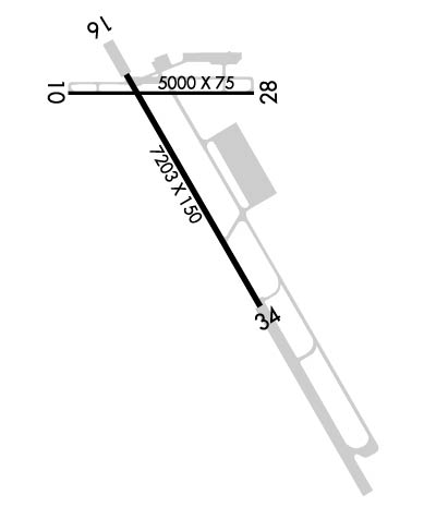
| Lat: N 4615.0 Long: W 08428.3 Elev: 799 Var: +07 Longest Runway: 7203 | ||
| AWOS: 127.57 CTAF: 123.0 | ||
| ||||||
| ||||||
|
| Rwy | Rwy | |||||||
| 5000x75 | 5000' | 5000x75 | 5000' | |||||
| 7203x150 | 7203' | 110.30 - 156° | 7203x150 | 7203' | ||||
| Runway ID | Single Wheel | Double Wheel | Double Tandem Wheel | Dual Double Wheel |
| 10/28 | 100,000 | 100,000 | N/A | N/A |
| 16/34 | 155,000 | 330,000 | 600,000 | N/A |
| These numbers are Advisory and are not limits. The Airport Manager should have more accurate Weight Limits | ||||
 Airport Diagram might not be current. | |
| Facility Name: | CHIPPEWA COUNTY INTL |
| City Name: | SAULT STE MARIE |
| County: | CHIPPEWA |
| State abbrev: | MI |
| State Name: | MICHIGAN |
| Ownership: | PUBLICLY OWNED |
| Use: | OPEN TO THE PUBLIC |
| Owner's Name: | CHIPPEWA COUNTY ECON DEV CORP |
| Address: | 5019 W AIRPORT DR |
| KINCHELOE, MI 49788-1643 | |
| Owner's Phone: | 906-495-5631 |
| Manager's Name: | TAMI L BESEAU |
| Address: | 5019 W AIRPORT DR |
| KINCHELOE, MI 49788-1643 | |
| Phone: | 906-495-5631; AFT HRS CELL 906-322-3651. |
| FAA Region: | GREAT LAKES |
| FAA Field Office: | DET |
| Date | Sunrise | Sunset |
|---|---|---|
| 09/24/21 Friday | 7:27 | 19:32 |
| 09/25/21 Saturday | 7:28 | 19:30 |
| 09/26/21 Sunday | 7:30 | 19:28 |
| 09/27/21 Monday | 7:31 | 19:26 |
| 09/28/21 Tuesday | 7:32 | 19:24 |
| 09/29/21 Wednesday | 7:33 | 19:22 |
| 09/30/21 Thursday | 7:35 | 19:20 |
| 10/01/21 Friday | 7:36 | 19:18 |
| 10/02/21 Saturday | 7:37 | 19:16 |
| 10/03/21 Sunday | 7:39 | 19:14 |
| 10/04/21 Monday | 7:40 | 19:12 |
| 10/05/21 Tuesday | 7:41 | 19:11 |
| 10/06/21 Wednesday | 7:43 | 19:09 |
| 10/07/21 Thursday | 7:44 | 19:07 |
| Airport Attendance Schedule | 7 Days A Week 0600-1800 |
| Airport Status | OPERATIONAL (This Status can change at any time - please check NOTAMS) |
| Airport Lighting Schedule | ACTVT MALSR RWY 16; REIL RWY 34, 10, & 28; PAPI RWY 16, 34, 10, & 28; HIRL RWY 16/34; MIRL RWY 10/28 - CTAF. REIL & PAPI RWY 34 OPR CONSLY DEC-MAR; PAPI RWY 10 & 28 OPR CONSLY DRG DALGT HRS. |
| Airport Storage Available | Tie Downs, Hanger |
| Extra Services Available | NONE |
| Wind Indicator | YES - (lighted) |
| Control Tower | NO |
| CTAF Frequency | 123.000 |
| Unicom Frequency | 123.000 |
| Rotating Beacon Color | CLEAR-GREEN (Light Land Airport) |
| Segmented Circle | YES |
| Landing Fee | NO |
| Airport Inspected | FEDERAL - performed by FAA AIRPORTS FIELD PERSONNEL |
| Inspection Date | 09/25/2019 |
| Type of Fuel Available | Grade 100LL, JET A (freeze point -40C) |
| Airframe Repair Service | None |
| Power Plant Repair Service | None |
| Latitude | N4615.0 |
| Longitude | W08428.3 (ESTIMATED) |
| Arpt Elevation | 799ft (SURVEYED) |
| Magnetic Variation | 07W |
| 15 miles S | of SAULT STE MARIE |
| Traffic Pattern Altitude | 800 |
| Sectional Chart | LAKE HURON |
| Operations (Reported) | Yearly | Avg. Daily |
|---|---|---|
| General Aviation Transient | 475 | 1 |
| General Aviation Local | 353 | 1 |
| Air Taxi | 1184 | 3 |
| Commerical | 1456 | 4 |
| Commuter | 0 | 0 |
| Military | 30 | 0 |
| Aircraft based on Field | |
|---|---|
| General Aviation Singles | 6 |
| General Aviation Multi | 2 |
| Jet Aircraft | 1 |
| General Aviation Helicopters | 0 |
| Military Aircraft | 0 |
| Gliders | 0 |
| Ultralights | 0 |
| FSS on field | NO |
| FSS tie-in | GREEN BAY |
| FSS Phone | 1-800-WX-BRIEF |
| Who issues Notams | CIU |
| Notam D service at airport | YES |
| ARTCC Name | MINNEAPOLIS |
| Airport Certification | AIRPORT RECEIVING SCHEDULED AIR CARRIER SERVICE FROM CARRIERS CERTIFICATED BY THE CIVIL AERONAUTICS BOARD; 24 HR PPR FOR UNSKED ACR OPS GTR THAN 9 PAX SEATS - CALL AMGR. |
| Aircraft Rescue & Firefighting Index | AIRPORT HAS A CERTIFICATE UNDER CFR PART 139 |
| Airport of Entry | YES |
| Custom Landing Rights | No |
| Joint Civil/Military | No |
| Military Landing rights | YES |
| NATIONAL PLAN OF INTEGRATED AIRPORT SYSTEMS (NPIAS) |
| GRANT AGREEMENTS UNDER FAAP/ADAP/AIP |
| SURPLUS PROPERTY AGREEMENT UNDER PUBLIC LAW 289 |
| ASSURANCES PURSUANT TO TITLE VI, CIVIL RIGHTS ACT OF 1964 |
| BIRDS ON & INVOF ARPT. |
| EXP SNOW REMOVAL ACT DLY DEC-MAR. |
| VEHICLE TESTING INPR DRG WINTER MONTHS ON SECTIONS OF CLSD/ABNDD PARL TWY, SE OF APCH END RWY 34. AREA MAY BE PLOWED TO BARE SFC BUT UNAVBL FOR ARR OR DEP. |
| FLD CONDS UNMON 1600-0800. |
| FOR CD IF UNA TO CTC ON FSS FREQ, CTC MINNEAPOLIS ARTCC AT 651-463-5588. |
| RWY 16/3 4 CNTR 150 FT IS ASPH, RMNG OUTSIDE EDGES ARE CONC. |
Airport Communications & Frequencies:
| |||||||||
| Runway: 10 | Runway: 28 | ||
| Mag heading: | 97° | Mag heading: | 277° |
| Rwy Slope: | .15% Up | Rwy Slope: | -.15% Down |
| Approach: | Approach: | ||
| Pattern: | Left Traffic | Pattern: | Left Traffic |
| Markings: | NONPRECISION INSTRUMENT | Markings: | NONPRECISION INSTRUMENT |
| Marking Condition: | FAIR | Marking Condition: | FAIR |
| Arresting Dev: | Arresting Dev: | ||
| Lat & Long: | N4615.3 W08429.1 | Lat. & Long.: | N4615.3 W08427.9 |
| Elev: | 791.4 ft. MSL | Elev: | 799.1 ft. MSL |
| TCH: | 40 ft. AGL | TCH: | 40 ft. AGL |
| Visual Glide Path: | 3.00 degrees | Visual Glide Path: | 3.00 degrees |
| Displaced Threshold: | No | Displaced Threshold: | No |
| Touchdown Zone: | YES | Touchdown Zone: | YES |
| Touchdown Elev.: | 798.5 feet | Touchdown Elev.: | 799.2 feet |
| Visual Glide Slope: | 4-Light PAPI on LEFT side of Runway | Visual Glide Slope: | 4-Light PAPI on LEFT side of Runway; PAPI UNUSBL BYD 8 DEGS LEFT OF CNTRLN. |
| RVR Equipment: | RVR Equipment: | ||
| RVV Equipment: | NO | RVV Equipment: | NO |
| Approach Lights: | Approach Lights: | ||
| REIL: | YES | REIL: | YES |
| Centerline Lights: | NO | Centerline Lights: | NO |
| Touchdown lights: | NO | Touchdown lights: | NO |
| Runway Category: | Runway with a Non-precision Approach having visibility minimums greater than 3/4 mile | Runway Category: | Runway with a Non-precision Approach having visibility minimums greater than 3/4 mile |
| Declared Distances: | TORA:5000' TODA:5000' ASDA:5000' LDA:5000' | Declared Distances: | TORA:5000' TODA:5000' ASDA:5000' LDA:5000' |
| Obstructions: | TREES | Obstructions: | TREES |
| Marked: | NOT Marked/Lighted | Marked: | NOT Marked/Lighted |
| Clearance slope: | 29:1 | Clearance slope: | 31:1 |
| Obstruction height: | 57 feet AGL | Obstruction height: | 51 feet AGL |
| Dist. from runway: | 1900 feet | Dist. from runway: | 1800 feet |
| Centerline offset: | 50 left of centerline | Centerline offset: | 200 feet left of centerline |
| Comments: | Comments: |
| Runway: 16 | Runway: 34 | ||
| Mag heading: | 157° | Mag heading: | 337° |
| Rwy Slope: | -.07% Down | Rwy Slope: | .07% Up |
| Approach: | ILS | Approach: | |
| Pattern: | Right Traffic | Pattern: | Left Traffic |
| Markings: | PRECISION INSTRUMENT | Markings: | PRECISION INSTRUMENT |
| Marking Condition: | FAIR | Marking Condition: | FAIR |
| Arresting Dev: | Arresting Dev: | ||
| Lat & Long: | N4615.4 W08428.7 | Lat. & Long.: | N4614.4 W08427.8 |
| Elev: | 798.5 ft. MSL | Elev: | 793.4 ft. MSL |
| TCH: | 57 ft. AGL | TCH: | 41 ft. AGL |
| Visual Glide Path: | 3.00 degrees | Visual Glide Path: | 3.00 degrees |
| Displaced Threshold: | No | Displaced Threshold: | No |
| Touchdown Zone: | YES | Touchdown Zone: | YES |
| Touchdown Elev.: | 798.6 feet | Touchdown Elev.: | 796.0 feet |
| Visual Glide Slope: | 4-Light PAPI on LEFT side of Runway | Visual Glide Slope: | 4-Light PAPI on LEFT side of Runway |
| RVR Equipment: | RVR Equipment: | ||
| RVV Equipment: | NO | RVV Equipment: | NO |
| Approach Lights: | MALSR - 1,400 foot medium intensity approach lighting system with runway alignment indicator lights | Approach Lights: | |
| REIL: | NO | REIL: | YES |
| Centerline Lights: | NO | Centerline Lights: | NO |
| Touchdown lights: | NO | Touchdown lights: | NO |
| Runway Category: | Precision Instrument Runway | Runway Category: | Runway with a Non-precision Approach having visibility minimums greater than 3/4 mile |
| Declared Distances: | TORA:7203' TODA:7203' ASDA:7203' LDA:7203' | Declared Distances: | TORA:7203' TODA:7203' ASDA:7203' LDA:7203' |
Thanks for using FltPlan.com
all rights reserved © 1999-2021 by Flight Plan LLC
