
| CEDAR CITY RGNL CEDAR CITY UT |
| |
| Lat: N 3742.1 Long: W 11305.9 Elev: 5622 Var: -14 Longest Runway: 8653 | ||
| AWOS: 119.02 CTAF: 123.0 | ||
| ||||||||||||||||||||||||||||||||||||||||||||
| ||||||||||||||||||||||||||||||||||||||||||||
| ||||||||||||||||||||||||||||||||||||||||||||
| Rwy | Rwy | |||||||
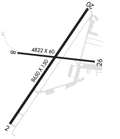
| 8653x150 | 8653' | 8653x150 | 8653' | 110.10 - 200° | ||||
| 4822x60 | 4822' | 4822x60 | 4822' | |||||
| Runway ID | Single Wheel | Double Wheel | Double Tandem Wheel | Dual Double Wheel |
| 02/20 | 56,000 | 76,000 | 127,000 | 142,000 |
| 08/26 | 16,000 | N/A | N/A | N/A |
| These numbers are Advisory and are not limits. The Airport Manager should have more accurate Weight Limits | ||||
 Airport Diagram might not be current. | |
| Facility Name: | CEDAR CITY RGNL |
| City Name: | CEDAR CITY |
| County: | IRON |
| State abbrev: | UT |
| State Name: | UTAH |
| Ownership: | PUBLICLY OWNED |
| Use: | OPEN TO THE PUBLIC |
| Owner's Name: | CEDAR CITY CORPORATION |
| Address: | 10 NORTH MAIN |
| CEDAR CITY, UT 84720 | |
| Owner's Phone: | 435-586-2950 |
| Manager's Name: | TYLER GALETKA |
| Address: | 2560 AVIATION WAY |
| CEDAR CITY, UT 84721 | |
| Phone: | 435-867-9408 |
| FAA Region: | NORTHWEST MOUNTAIN |
| FAA Field Office: | DEN |

| Date | Sunrise | Sunset |
|---|---|---|
| 06/08/26 Monday | 6:10 | 20:53 |
| 06/09/26 Tuesday | 6:10 | 20:53 |
| 06/10/26 Wednesday | 6:10 | 20:54 |
| 06/11/26 Thursday | 6:10 | 20:54 |
| 06/12/26 Friday | 6:10 | 20:54 |
| 06/13/26 Saturday | 6:10 | 20:55 |
| 06/14/26 Sunday | 6:10 | 20:55 |
| 06/15/26 Monday | 6:10 | 20:56 |
| 06/16/26 Tuesday | 6:10 | 20:56 |
| 06/17/26 Wednesday | 6:10 | 20:56 |
| 06/18/26 Thursday | 6:10 | 20:57 |
| 06/19/26 Friday | 6:10 | 20:57 |
| 06/20/26 Saturday | 6:11 | 20:57 |
| 06/21/26 Sunday | 6:11 | 20:57 |
| Airport Attendance Schedule | 7 Days A Week DALGT; FOR AFT HRS SVC CALL 435-586-4504 |
| Airport Status | OPERATIONAL (This Status can change at any time - please check NOTAMS) |
| Airport Lighting Schedule | ACTVT MALSR RWY 20; REIL RWY 02, 08 & 26; HIRL RWY 02/20; MIRL RWY 08/26 - CTAF. PAPI RWY 02 & 20, 08 OPER CONSLY. |
| Airport Storage Available | Tie Downs, Hanger |
| Extra Services Available | Air Freight, Crop Dusting, Air Ambulance, Cargo Handling, Charter, Flight Instruction, Aircraft Rental, Aircraft Sales, Glider Towing |
| Wind Indicator | YES - (lighted) |
| Control Tower | NO |
| CTAF Frequency | 123.000 |
| Unicom Frequency | 123.000 |
| Rotating Beacon Color | WG |
| Segmented Circle | YES |
| Landing Fee | NO |
| Airport Inspected | FEDERAL - performed by FAA AIRPORTS FIELD PERSONNEL |
| Inspection Date | 02/05/2025 |
| Type of Fuel Available | Grade 100LL, JET A (freeze point -40C); -10100LL FUEL AVBL 24 HRS SELF-SVC CREDIT CARD SYSTEM. |
| Airframe Repair Service | MAJOR |
| Power Plant Repair Service | MAJOR |
| Latitude | N3742.1 |
| Longitude | W11305.9 (ESTIMATED) |
| Arpt Elevation | 5622ft (SURVEYED) |
| Magnetic Variation | 14E |
| 2 miles NW | of CEDAR CITY |
| Traffic Pattern Altitude | 777 |
| Sectional Chart | LAS VEGAS |
| Operations (Reported) | Yearly | Avg. Daily |
|---|---|---|
| General Aviation Transient | 0 | 0 |
| General Aviation Local | 0 | 0 |
| Air Taxi | 0 | 0 |
| Commerical | 0 | 0 |
| Commuter | 0 | 0 |
| Military | 0 | 0 |
| Aircraft based on Field | |
|---|---|
| General Aviation Singles | 0 |
| General Aviation Multi | 0 |
| Jet Aircraft | 0 |
| General Aviation Helicopters | 0 |
| Military Aircraft | 0 |
| Gliders | 0 |
| Ultralights | 0 |
| FSS on field | NO |
| FSS tie-in | CEDAR CITY |
| FSS Phone | 1-800-WX-BRIEF |
| Who issues Notams | CDC |
| Notam D service at airport | YES |
| ARTCC Name | SALT LAKE CITY |
| Airport Certification | AIRPORT RECEIVING SCHEDULED AIR CARRIER SERVICE FROM CARRIERS CERTIFICATED BY THE CIVIL AERONAUTICS BOARD; CLSD TO UNSKED ACR OPNS WITH MORE THAN 30 PSGR SEATS EXCP 24 HR PPR CALL CC FIRE DEPT 435-586-2964 AND AMGR 435-867-9408. |
| Aircraft Rescue & Firefighting Index | AIRPORT HAS A CERTIFICATE UNDER CFR PART 139 |
| Airport of Entry | No |
| Custom Landing Rights | No |
| Joint Civil/Military | No |
| Military Landing rights | YES |
| NATIONAL PLAN OF INTEGRATED AIRPORT SYSTEMS (NPIAS) |
| GRANT AGREEMENTS UNDER FAAP/ADAP/AIP |
| CONVEYANCE UNDER SCETION 16, FEDERAL AIRPORT ACT OF 1946 OR SECTION 23, AIRPORT AND AIRWAY DEVELOPMENT ACT OF 1970 |
| ASSURANCES PURSUANT TO TITLE VI, CIVIL RIGHTS ACT OF 1964 |
| AGREEMENT UNDER DLAND OR DCLA HAS EXPIRED. |
| GA ACFT NOT PERMITTED ON ACR RAMP. |
| AUTOROTATE - NO AUTOROTATION TRNG TO HELIPAD. RWY 02/20 CLSD TO HEL RUN-ON LNDG; RWY 08/26 CLSD TO HEL RUN-ON LNDG; TWY A, N OF RWY 8/26 CLSD TO HEL RUN-ON LNDG; TWY C CLSD TO HEL RUN-ON LNDG. |
| RWY 02 LEFT TRAFFIC PATTERN EXC HELICOPTERS. RWY 20 RIGHT TRAFFIC EXC HELICOPTERS. |
| FOR CD IF UNA TO CTC ON FSS FREQ, CTC SALT LAKE ARTCC AT 801-320-2568. |
| RWY 2/20, A, A1-A4, C FM A TO TRML & TRML APN AVBL TO ACRS. |
| RECOMMNED PILOTS CIRCLE ARPT FOR ALT BEFORE DEPARTING EASTBOUND DUE TO FAST RISING TERRAIN AND HI DENSITY ALT. TURBC LIKELY INVOF MNTS & PASSES. |
| DESIGNATED CALM WIND RWY (BLW 5 KTS) IS RWY 20, RGT TFC. |
| UNMON SFC CONDS 1900-0700 DLY EXC FOR SKED ACR. |
| EXTENSIVE HELICOPTER ACTIVITY. |
| EXTENSIVE FLIGHT TRNG INVOF ARPT. |
| RWY 08/2 6 RWY 08/26 NOT AVBL FOR PART 121/PART 380 OPS WITH SKED PAX CARRYING OPS MORE THAN 9 PAX SEATS AND NON-SKED PAX CARRYING OPS MORE THAN 30 PAX SEATS. |
| RWY 02/2 0 PCR VALUE: 410/F/B/X/T |
| RWY 08/2 6 PCR VALUE: 40/F/B/X/T |
Airport Communications & Frequencies:
| |||||||||
| Runway: 02 | Runway: 20 | ||
| Mag heading: | 20° | Mag heading: | 200° |
| Rwy Slope: | .29% Up | Rwy Slope: | -.29% Down |
| Approach: | Approach: | ILS | |
| Pattern: | Left Traffic | Pattern: | Right Traffic |
| Markings: | NONPRECISION INSTRUMENT | Markings: | PRECISION INSTRUMENT |
| Marking Condition: | GOOD | Marking Condition: | GOOD |
| Arresting Dev: | Arresting Dev: | ||
| Lat & Long: | N3741.4 W11306.5 | Lat. & Long.: | N3742.6 W11305.5 |
| Elev: | 5579.8 ft. MSL | Elev: | 5605.3 ft. MSL |
| TCH: | 48 ft. AGL | TCH: | 50 ft. AGL |
| Visual Glide Path: | 3.00 degrees | Visual Glide Path: | 3.00 degrees |
| Displaced Threshold: | No | Displaced Threshold: | No |
| Touchdown Zone: | YES | Touchdown Zone: | YES |
| Touchdown Elev.: | 5591.8 feet | Touchdown Elev.: | 5605.3 feet |
| Visual Glide Slope: | 4-Light PAPI on LEFT side of Runway | Visual Glide Slope: | 4-Light PAPI on LEFT side of Runway |
| RVR Equipment: | RVR Equipment: | ||
| RVV Equipment: | NO | RVV Equipment: | NO |
| Approach Lights: | Approach Lights: | MALSR - 1,400 foot medium intensity approach lighting system with runway alignment indicator lights | |
| REIL: | YES | REIL: | NO |
| Centerline Lights: | NO | Centerline Lights: | NO |
| Touchdown lights: | NO | Touchdown lights: | NO |
| Runway Category: | Runway with a Visual Approach | Runway Category: | Precision Instrument Runway |
| Declared Distances: | TORA:8653' TODA:8653' ASDA:8653' LDA:8653' | Declared Distances: | TORA:8653' TODA:8653' ASDA:8653' LDA:8653' |
| Runway: 08 | Runway: 26 | ||
| Mag heading: | 83° | Mag heading: | 263° |
| Rwy Slope: | .91% Up | Rwy Slope: | -.91% Down |
| Approach: | Approach: | ||
| Pattern: | Left Traffic | Pattern: | Right Traffic |
| Markings: | BASIC | Markings: | BASIC |
| Marking Condition: | GOOD | Marking Condition: | GOOD |
| Arresting Dev: | Arresting Dev: | ||
| Lat & Long: | N3742.2 W11306.4 | Lat. & Long.: | N3742.1 W11305.4 |
| Elev: | 5578.6 ft. MSL | Elev: | 5622.3 ft. MSL |
| TCH: | 47 ft. AGL | TCH: | |
| Visual Glide Path: | 3.00 degrees | Visual Glide Path: | |
| Displaced Threshold: | No | Displaced Threshold: | No |
| Touchdown Zone: | YES | Touchdown Zone: | YES |
| Touchdown Elev.: | 5604.0 feet | Touchdown Elev.: | 5622.3 feet |
| Visual Glide Slope: | 4-Light PAPI on LEFT side of Runway | Visual Glide Slope: | |
| RVR Equipment: | RVR Equipment: | ||
| RVV Equipment: | NO | RVV Equipment: | NO |
| Approach Lights: | Approach Lights: | ||
| REIL: | YES | REIL: | YES |
| Centerline Lights: | NO | Centerline Lights: | NO |
| Touchdown lights: | NO | Touchdown lights: | NO |
| Runway Category: | Runway with a Visual Approach | Runway Category: | Runway with a Visual Approach |
| Declared Distances: | TORA:4822' TODA:4822' ASDA:4822' LDA:4822' | Declared Distances: | TORA:4822' TODA:4822' ASDA:4822' LDA:4822' |
| Obstructions: | POLE | Obstructions: | ROAD |
| Marked: | NOT Marked/Lighted | Marked: | NOT Marked/Lighted |
| Clearance slope: | 40:1 | Clearance slope: | 26:1 |
| Obstruction height: | 40 feet AGL | Obstruction height: | 18 feet AGL |
| Dist. from runway: | 1800 feet; 40 FT POLES ON EXTNDD RWY CNTRLN. | Dist. from runway: | 661 feet |
| Centerline offset: | Centerline offset: | ||
| Comments: | Comments: |
Thanks for using FltPlan.com
all rights reserved © 1999-2026 by Flight Plan LLC