
| MONMOUTH MUNI MONMOUTH IL |
| |
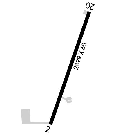
| Lat: N 4055.8 Long: W 09037.9 Elev: 753 Var: -03 Longest Runway: 2899 | ||
| Clr Del: 120.7 CTAF: 122.8 | ||
| ||||||
|
| Rwy | Rwy | |||||||
| 2899x60 | 2899' | 2899x60 | 2899' | |||||
| Runway ID | Single Wheel | Double Wheel | Double Tandem Wheel | Dual Double Wheel |
| 03/21 | 10,000 | N/A | N/A | N/A |
| These numbers are Advisory and are not limits. The Airport Manager should have more accurate Weight Limits | ||||
 Airport Diagram might not be current. | |
| Facility Name: | MONMOUTH MUNI |
| City Name: | MONMOUTH |
| County: | WARREN |
| State abbrev: | IL |
| State Name: | ILLINOIS |
| Ownership: | PUBLICLY OWNED |
| Use: | OPEN TO THE PUBLIC |
| Owner's Name: | CITY OF MONMOUTH |
| Address: | 100 E. BROADWAY |
| MONMOUTH, IL 61462-1764 | |
| Owner's Phone: | 309-734-2141 |
| Manager's Name: | MEL LYNCH |
| Address: | 100 E. BROADWAY; EMAIL ADDRESS: ULYNCH@LIVE.COM (ALL LOWER CASE) |
| MONMOUTH, IL 61462-1764 | |
| Phone: | 309-734-3411 |
| FAA Region: | GREAT LAKES |
| FAA Field Office: | CHI |
| Date | Sunrise | Sunset |
|---|---|---|
| 09/24/21 Friday | 6:52 | 18:57 |
| 09/25/21 Saturday | 6:53 | 18:55 |
| 09/26/21 Sunday | 6:54 | 18:53 |
| 09/27/21 Monday | 6:55 | 18:52 |
| 09/28/21 Tuesday | 6:56 | 18:50 |
| 09/29/21 Wednesday | 6:57 | 18:48 |
| 09/30/21 Thursday | 6:58 | 18:47 |
| 10/01/21 Friday | 6:59 | 18:45 |
| 10/02/21 Saturday | 7:00 | 18:43 |
| 10/03/21 Sunday | 7:01 | 18:42 |
| 10/04/21 Monday | 7:02 | 18:40 |
| 10/05/21 Tuesday | 7:03 | 18:38 |
| 10/06/21 Wednesday | 7:04 | 18:37 |
| 10/07/21 Thursday | 7:05 | 18:35 |
| Airport Attendance Schedule | TUE-SUN 0800-1630 |
| Airport Status | OPERATIONAL (This Status can change at any time - please check NOTAMS) |
| Airport Lighting Schedule | ACTVT PAPI RWY 03 & 21; MIRL RWY 03/21 PRESET LOW INTST, TO INCR INTST & ACTVT - CTAF. |
| Airport Storage Available | Tie Downs, Hanger |
| Extra Services Available | NONE |
| Wind Indicator | YES - (lighted) |
| Control Tower | NO |
| CTAF Frequency | 122.800 |
| Unicom Frequency | 122.800 |
| Rotating Beacon Color | CLEAR-GREEN (Light Land Airport) |
| Segmented Circle | YES |
| Landing Fee | NO |
| Airport Inspected | STATE - performed by STATE AERONAUTICAL PERSONNEL |
| Inspection Date | 09/13/2019 |
| Type of Fuel Available | Grade 100LLMOGAS; -10AFT HRS FUEL - 309-255-3455. |
| Airframe Repair Service | NONE |
| Power Plant Repair Service | NONE |
| Latitude | N4055.8 |
| Longitude | W09037.9 (ESTIMATED) |
| Arpt Elevation | 753ft (SURVEYED) |
| Magnetic Variation | 03E |
| 2 miles N | of MONMOUTH |
| Traffic Pattern Altitude | |
| Sectional Chart | CHICAGO |
| Operations (Reported) | Yearly | Avg. Daily |
|---|---|---|
| General Aviation Transient | 1800 | 5 |
| General Aviation Local | 3000 | 8 |
| Air Taxi | 200 | 1 |
| Commerical | 0 | 0 |
| Commuter | 0 | 0 |
| Military | 0 | 0 |
| Aircraft based on Field | |
|---|---|
| General Aviation Singles | 9 |
| General Aviation Multi | 0 |
| Jet Aircraft | 0 |
| General Aviation Helicopters | 0 |
| Military Aircraft | 0 |
| Gliders | 0 |
| Ultralights | 0 |
| FSS on field | NO |
| FSS tie-in | KANKAKEE |
| FSS Phone | 1-800-WX-BRIEF |
| Who issues Notams | IKK |
| Notam D service at airport | YES |
| ARTCC Name | CHICAGO |
| Airport Certification | |
| Aircraft Rescue & Firefighting Index | None |
| Airport of Entry | No |
| Custom Landing Rights | No |
| Joint Civil/Military | No |
| Military Landing rights | YES |
| NATIONAL PLAN OF INTEGRATED AIRPORT SYSTEMS (NPIAS) |
| GRANT AGREEMENTS UNDER FAAP/ADAP/AIP |
| ASSURANCES PURSUANT TO TITLE VI, CIVIL RIGHTS ACT OF 1964 |
| THIS AIRPORT HAS BEEN SURVEYED BY THE NATIONAL GEODETIC SURVEY. |
| FOR CD CTC CHICAGO ARTCC AT 630-906-8921. |
| RWY 03 SEASONAL CROPS IN PART 77 SFC; 200 FT FROM RWY END 61 FT L. |
Airport Communications & Frequencies:
| |||||||||||||||||||
| Runway: 03 | Runway: 21 | ||
| Mag heading: | 20° | Mag heading: | 200° |
| Rwy Slope: | -.17% Down | Rwy Slope: | .17% Up |
| Approach: | Approach: | ||
| Pattern: | Left Traffic | Pattern: | Left Traffic |
| Markings: | BASIC | Markings: | BASIC |
| Marking Condition: | GOOD | Marking Condition: | GOOD |
| Arresting Dev: | Arresting Dev: | ||
| Lat & Long: | N4055.6 W09038.0 | Lat. & Long.: | N4056.0 W09037.7 |
| Elev: | 753.0 ft. MSL | Elev: | 748.0 ft. MSL |
| TCH: | 29 ft. AGL | TCH: | 21 ft. AGL |
| Visual Glide Path: | 3.50 degrees | Visual Glide Path: | 3.00 degrees |
| Displaced Threshold: | No | Displaced Threshold: | No |
| Touchdown Zone: | YES | Touchdown Zone: | YES |
| Touchdown Elev.: | 753.0 feet | Touchdown Elev.: | 753.0 feet |
| Visual Glide Slope: | 2-Light PAPI on LEFT side of Runway | Visual Glide Slope: | 2-Light PAPI on LEFT side of Runway |
| RVR Equipment: | RVR Equipment: | ||
| RVV Equipment: | NO | RVV Equipment: | NO |
| Approach Lights: | Approach Lights: | ||
| REIL: | NO | REIL: | NO |
| Centerline Lights: | NO | Centerline Lights: | NO |
| Touchdown lights: | NO | Touchdown lights: | NO |
| Runway Category: | Runway with a Visual Approach | Runway Category: | Runway with a Visual Approach |
| Declared Distances: | Declared Distances: | ||
| Obstructions: | ROAD | Obstructions: | TREE |
| Marked: | NOT Marked/Lighted | Marked: | NOT Marked/Lighted |
| Clearance slope: | 21:1 | Clearance slope: | 15:1 |
| Obstruction height: | 14 feet AGL | Obstruction height: | 38 feet AGL |
| Dist. from runway: | 498 feet | Dist. from runway: | 776 feet |
| Centerline offset: | 153 right of centerline | Centerline offset: | 175 feet right of centerline |
| Comments: | Comments: |
Thanks for using FltPlan.com
all rights reserved © 1999-2021 by Flight Plan LLC
