| MONROE COUNTY BLOOMINGTON IN |
| |
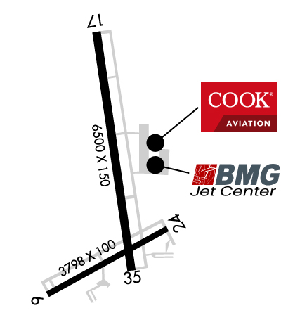
| Lat: N 3908.8 Long: W 08637.0 Elev: 846 Var: +02 Longest Runway: 6500 | ||
| AWOS: 110.2 Ground: 121.9 Tower: 120.77 | ||
| ||||||||||||||||||||||||||||||||||||||||||||||||||||||||||||||||||||
| ||||||||||||||||||||||||||||||||||||||||||||||||||||||||||||||||||||
| ||||||||||||||||||||||||||||||||||||||||||||||||||||||||||||||||||||
| ||||||||||||||||||||||||||||||||||||||||||||||||||||||||||||||||||||
| Rwy | Rwy | |||||||
| 3798x100 | 3494' | 3798x100 | 3576' | |||||
| 6500x150 | 6500' | 6500x150 | 6500' | 108.30 - 353° | ||||
| Runway ID | Single Wheel | Double Wheel | Double Tandem Wheel | Dual Double Wheel |
| 06/24 | 35,000 | 50,000 | N/A | N/A |
| 17/35 | 120,000 | 208,000 | 308,400 | 816,800 |
| These numbers are Advisory and are not limits. The Airport Manager should have more accurate Weight Limits | ||||
 Airport Diagram might not be current. | |
| Facility Name: | MONROE COUNTY |
| City Name: | BLOOMINGTON |
| County: | MONROE |
| State abbrev: | IN |
| State Name: | INDIANA |
| Ownership: | PUBLICLY OWNED |
| Use: | OPEN TO THE PUBLIC |
| Owner's Name: | MONROE COUNTY |
| Address: | 972 SOUTH KIRBY ROAD |
| BLOOMINGTON, IN 47403 | |
| Owner's Phone: | 812-825-5406 |
| Manager's Name: | CARLOS LAVERTY |
| Address: | 972 S. KIRBY RD |
| BLOOMINGTON, IN 47403 | |
| Phone: | 812-825-5406 |
| FAA Region: | GREAT LAKES |
| FAA Field Office: | CHI |
| Date | Sunrise | Sunset |
|---|---|---|
| 06/09/26 Tuesday | 6:20 | 21:11 |
| 06/10/26 Wednesday | 6:20 | 21:12 |
| 06/11/26 Thursday | 6:20 | 21:12 |
| 06/12/26 Friday | 6:20 | 21:13 |
| 06/13/26 Saturday | 6:20 | 21:13 |
| 06/14/26 Sunday | 6:20 | 21:14 |
| 06/15/26 Monday | 6:20 | 21:14 |
| 06/16/26 Tuesday | 6:20 | 21:15 |
| 06/17/26 Wednesday | 6:20 | 21:15 |
| 06/18/26 Thursday | 6:20 | 21:15 |
| 06/19/26 Friday | 6:20 | 21:15 |
| 06/20/26 Saturday | 6:20 | 21:16 |
| 06/21/26 Sunday | 6:20 | 21:16 |
| 06/22/26 Monday | 6:21 | 21:16 |
| Airport Attendance Schedule | 7 Days A Week 0630-2130 |
| Airport Status | OPERATIONAL (This Status can change at any time - please check NOTAMS) |
| Airport Lighting Schedule | WHEN ATCT CLSD ACTVT MALSR RWY 35; REIL RWY 17; PAPI RWY 24; MIRL RWY 06/24; HIRL RWY 17/35 - CTAF. PAPI RWY 17 ON CONSLY. |
| Airport Storage Available | Tie Downs, Hanger |
| Extra Services Available | Charter, Flight Instruction, Aircraft Rental |
| Wind Indicator | YES - (lighted) |
| Control Tower | YES |
| CTAF Frequency | 120.775 |
| Unicom Frequency | 122.950 |
| Rotating Beacon Color | WG |
| Segmented Circle | YES |
| Landing Fee | NO |
| Airport Inspected | FEDERAL - performed by FAA AIRPORTS FIELD PERSONNEL |
| Inspection Date | 12/07/2022 |
| Type of Fuel Available | Grade 100LL, JET A (freeze point -40C) |
| Airframe Repair Service | MAJOR |
| Power Plant Repair Service | MAJOR |
| Latitude | N3908.8 |
| Longitude | W08637.0 (ESTIMATED) |
| Arpt Elevation | 845ft (SURVEYED) |
| Magnetic Variation | 02W |
| 4 miles SW | of BLOOMINGTON |
| Traffic Pattern Altitude | |
| Sectional Chart | ST LOUIS |
| Operations (Reported) | Yearly | Avg. Daily |
|---|---|---|
| General Aviation Transient | 0 | 0 |
| General Aviation Local | 0 | 0 |
| Air Taxi | 0 | 0 |
| Commerical | 0 | 0 |
| Commuter | 0 | 0 |
| Military | 0 | 0 |
| Aircraft based on Field | |
|---|---|
| General Aviation Singles | 0 |
| General Aviation Multi | 0 |
| Jet Aircraft | 0 |
| General Aviation Helicopters | 0 |
| Military Aircraft | 0 |
| Gliders | 0 |
| Ultralights | 0 |
| FSS on field | NO |
| FSS tie-in | TERRE HAUTE |
| FSS Phone | 1-800-WX-BRIEF |
| Who issues Notams | BMG |
| Notam D service at airport | YES |
| ARTCC Name | INDIANAPOLIS |
| Airport Certification | CLSD TO SKED ACR OPS GTR THAN 9 PAX SEATS. UNSKED ACR OPS GTR THAN 30 PAX SEATS PPR - OPS MGR 812-825-5406 OR 812-606-6659 AT NIGHT OR ON WKEND & HOL. INDEX B ARFF CAPABILITY AVBL ON REQ. |
| Aircraft Rescue & Firefighting Index | AIRPORT HAS A CERTIFICATE UNDER CFR PART 139 |
| Airport of Entry | No |
| Custom Landing Rights | No |
| Joint Civil/Military | No |
| Military Landing rights | YES |
| NATIONAL PLAN OF INTEGRATED AIRPORT SYSTEMS (NPIAS) |
| GRANT AGREEMENTS UNDER FAAP/ADAP/AIP |
| ASSURANCES PURSUANT TO TITLE VI, CIVIL RIGHTS ACT OF 1964 |
| AGREEMENT UNDER DLAND OR DCLA HAS EXPIRED. |
| SFC COND UNMNT MON-FRI 1600-0800 & WKEND. |
| FOR CD CTC HULMAN APCH AT 812-877-7581. |
| RWY 06/2 4 RWY 06/24 NOT AVBL FOR PART 121/PART 380 OPS WITH SKED PAX CARRYING OPS MORE THAN 9 PAX SEATS AND NON-SKED PAX CARRYING OPS MORE THAN 30 PAX SEATS. AVBL ACR TAX ONLY. |
| RWY 17/3 5 PCR VALUE: 568/F/C/X/T |
Airport Communications & Frequencies:
| ||||||||||||||||||||
| Runway: 06 | Runway: 24 | ||
| Mag heading: | 64° | Mag heading: | 244° |
| Rwy Slope: | .22% Up | Rwy Slope: | -.22% Down |
| Approach: | Approach: | ||
| Pattern: | Left Traffic | Pattern: | Left Traffic |
| Markings: | NONPRECISION INSTRUMENT | Markings: | NONPRECISION INSTRUMENT |
| Marking Condition: | GOOD | Marking Condition: | GOOD |
| Arresting Dev: | Arresting Dev: | ||
| Lat & Long: | N3908.3 W08637.4 | Lat. & Long.: | N3908.6 W08636.7 |
| Elev: | 832.1 ft. MSL | Elev: | 840.6 ft. MSL |
| TCH: | TCH: | 37 ft. AGL | |
| Visual Glide Path: | Visual Glide Path: | 4.00 degrees | |
| Displaced Threshold: | 304 feet | Displaced Threshold: | 222 feet |
| Touchdown Zone: | YES | Touchdown Zone: | YES |
| Touchdown Elev.: | 840.5 feet | Touchdown Elev.: | 840.7 feet |
| Visual Glide Slope: | Visual Glide Slope: | 4-Light PAPI on LEFT side of Runway | |
| RVR Equipment: | RVR Equipment: | ||
| RVV Equipment: | NO | RVV Equipment: | NO |
| Approach Lights: | Approach Lights: | ||
| REIL: | NO | REIL: | NO |
| Centerline Lights: | NO | Centerline Lights: | NO |
| Touchdown lights: | NO | Touchdown lights: | NO |
| Runway Category: | Runway with a Non-precision Approach | Runway Category: | Runway with a Non-precision Approach |
| Declared Distances: | Declared Distances: | ||
| Obstructions: | ROAD | Obstructions: | ROAD |
| Marked: | NOT Marked/Lighted | Marked: | NOT Marked/Lighted |
| Clearance slope: | APCH RATIO 19:1 TO DTHR; 64 FT TREES 950 FT FM RWY 210 FT R. | Clearance slope: | APCH RATIO 12:1; 19 FT ROAD 245 FT FM DTHR 250 FT L. |
| Obstruction height: | 22 feet AGL | Obstruction height: | 18 feet AGL |
| Dist. from runway: | 200 feet | Dist. from runway: | 200 feet |
| Centerline offset: | 204 right of centerline | Centerline offset: | 100 feet left of centerline |
| Comments: | ROAD 100-200 FT FM THR 200-250 FT R. | Comments: | 7 FT FENCE 175 FT FM THR 113 FT L OF RWY EXTDD CTRLN. |
| Runway: 17 | Runway: 35 | ||
| Mag heading: | 174° | Mag heading: | 354° |
| Rwy Slope: | -.12% Down | Rwy Slope: | .12% Up |
| Approach: | Approach: | ILS | |
| Pattern: | Left Traffic | Pattern: | Left Traffic |
| Markings: | NONPRECISION INSTRUMENT | Markings: | PRECISION INSTRUMENT |
| Marking Condition: | GOOD | Marking Condition: | GOOD |
| Arresting Dev: | Arresting Dev: | ||
| Lat & Long: | N3909.5 W08637.1 | Lat. & Long.: | N3908.4 W08636.9 |
| Elev: | 845.5 ft. MSL | Elev: | 837.7 ft. MSL |
| TCH: | 41 ft. AGL | TCH: | |
| Visual Glide Path: | 3.00 degrees | Visual Glide Path: | |
| Displaced Threshold: | No | Displaced Threshold: | No |
| Touchdown Zone: | YES | Touchdown Zone: | YES |
| Touchdown Elev.: | 845.5 feet | Touchdown Elev.: | 844.4 feet |
| Visual Glide Slope: | 4-Light PAPI on LEFT side of Runway | Visual Glide Slope: | |
| RVR Equipment: | RVR Equipment: | ||
| RVV Equipment: | NO | RVV Equipment: | NO |
| Approach Lights: | Approach Lights: | MALSR - 1,400 foot medium intensity approach lighting system with runway alignment indicator lights | |
| REIL: | YES | REIL: | NO |
| Centerline Lights: | NO | Centerline Lights: | NO |
| Touchdown lights: | NO | Touchdown lights: | NO |
| Runway Category: | Runway with a Non-precision Approach having visibility minimums greater than 3/4 mile | Runway Category: | Precision Instrument Runway |
| Declared Distances: | Declared Distances: | ||
| Obstructions: | TREE | Obstructions: | |
| Marked: | NOT Marked/Lighted | Marked: | |
| Clearance slope: | 40:1 | Clearance slope: | 50:1 |
| Obstruction height: | 60 feet AGL | Obstruction height: | |
| Dist. from runway: | 2600 feet | Dist. from runway: | |
| Centerline offset: | 1100 right of centerline | Centerline offset: | |
| Comments: | Comments: |
Thanks for using FltPlan.com
all rights reserved © 1999-2026 by Flight Plan LLC