| BEATRICE MUNI BEATRICE NE |
| |
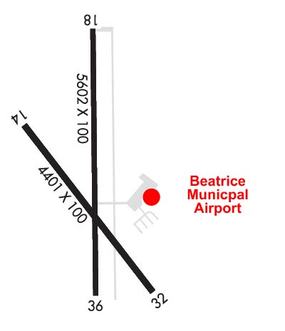
| Lat: N 4018.1 Long: W 09645.2 Elev: 1324 Var: -04 Longest Runway: 5602 | ||
| AWOS: 125.32 CTAF: 122.8 | ||
| |||||||||||||||||||||||||||||||||||||||||||||||||||||||||||||
| |||||||||||||||||||||||||||||||||||||||||||||||||||||||||||||
| |||||||||||||||||||||||||||||||||||||||||||||||||||||||||||||
| Rwy | Rwy | |||||||
| 4401x75 | 4401' | 4401x75 | 4401' | |||||
| 5602x100 | 5602' | 5602x100 | 5602' | |||||
| Runway ID | Single Wheel | Double Wheel | Double Tandem Wheel | Dual Double Wheel |
| 14/32 | 35,000 | 45,500 | N/A | N/A |
| 18/36 | 35,000 | 45,500 | N/A | N/A |
| These numbers are Advisory and are not limits. The Airport Manager should have more accurate Weight Limits | ||||
 Airport Diagram might not be current. | |
| Facility Name: | BEATRICE MUNI |
| City Name: | BEATRICE |
| County: | GAGE |
| State abbrev: | NE |
| State Name: | NEBRASKA |
| Ownership: | PUBLICLY OWNED |
| Use: | OPEN TO THE PUBLIC |
| Owner's Name: | CITY OF BEATRICE |
| Address: | BOX 277 |
| BEATRICE, NE 68310-0277 | |
| Owner's Phone: | 402-223-5349 |
| Manager's Name: | DENNIS SCHMITT |
| Address: | P.O. BOX 277 |
| BEATRICE, NE 68310-0277 | |
| Phone: | 402-223-5349 |
| FAA Region: | CENTRAL |
| FAA Field Office: | NONE |
| Date | Sunrise | Sunset |
|---|---|---|
| 04/24/24 Wednesday | 6:35 | 20:16 |
| 04/25/24 Thursday | 6:33 | 20:17 |
| 04/26/24 Friday | 6:32 | 20:18 |
| 04/27/24 Saturday | 6:31 | 20:19 |
| 04/28/24 Sunday | 6:29 | 20:20 |
| 04/29/24 Monday | 6:28 | 20:21 |
| 04/30/24 Tuesday | 6:27 | 20:22 |
| 05/01/24 Wednesday | 6:25 | 20:23 |
| 05/02/24 Thursday | 6:24 | 20:24 |
| 05/03/24 Friday | 6:23 | 20:25 |
| 05/04/24 Saturday | 6:22 | 20:26 |
| 05/05/24 Sunday | 6:21 | 20:27 |
| 05/06/24 Monday | 6:19 | 20:28 |
| 05/07/24 Tuesday | 6:18 | 20:29 |
| Airport Attendance Schedule | 7 Days A Week 0700-1900; WINTER HOURS 0700-1800 |
| Airport Status | OPERATIONAL (This Status can change at any time - please check NOTAMS) |
| Airport Lighting Schedule | ACTVT MALSR RWY 36; REIL RWY 14 & 32 - CTAF. MIRL RWY 14/32 & RWY 18/36 OPR SS-SR. PAPI RWY 36 OPR CONSLY. |
| Airport Storage Available | Tie Downs, Hanger |
| Extra Services Available | Air Freight, Crop Dusting, Avionics, Flight Instruction, Aircraft Rental |
| Wind Indicator | YES - (lighted) |
| Control Tower | NO |
| CTAF Frequency | 122.800 |
| Unicom Frequency | 122.800 |
| Rotating Beacon Color | WG |
| Segmented Circle | YES |
| Landing Fee | NO |
| Airport Inspected | STATE - performed by STATE AERONAUTICAL PERSONNEL |
| Inspection Date | 06/21/2023 |
| Type of Fuel Available | Grade 100LL, JET A (freeze point -40C); -10FUEL AVBL H24 VIA CREDIT CARD.; -A JET A FUEL SVC AFT HRS CALL 913-433-4671 OR 402-520-0856. |
| Airframe Repair Service | MINOR |
| Power Plant Repair Service | MINOR |
| Latitude | N4018.1 |
| Longitude | W09645.2 (ESTIMATED) |
| Arpt Elevation | 1323ft (SURVEYED) |
| Magnetic Variation | 04E |
| 3 miles N | of BEATRICE |
| Traffic Pattern Altitude | |
| Sectional Chart | OMAHA |
| Operations (Reported) | Yearly | Avg. Daily |
|---|---|---|
| General Aviation Transient | 4150 | 11 |
| General Aviation Local | 5950 | 16 |
| Air Taxi | 700 | 2 |
| Commerical | 0 | 0 |
| Commuter | 0 | 0 |
| Military | 200 | 1 |
| Aircraft based on Field | |
|---|---|
| General Aviation Singles | 32 |
| General Aviation Multi | 0 |
| Jet Aircraft | 0 |
| General Aviation Helicopters | 0 |
| Military Aircraft | 0 |
| Gliders | 0 |
| Ultralights | 0 |
| FSS on field | NO |
| FSS tie-in | COLUMBUS |
| FSS Phone | 1-800-WX-BRIEF |
| Who issues Notams | BIE |
| Notam D service at airport | YES |
| ARTCC Name | MINNEAPOLIS |
| Airport Certification | |
| Aircraft Rescue & Firefighting Index | None |
| Airport of Entry | No |
| Custom Landing Rights | No |
| Joint Civil/Military | No |
| Military Landing rights | YES |
| NATIONAL PLAN OF INTEGRATED AIRPORT SYSTEMS (NPIAS) |
| GRANT AGREEMENTS UNDER FAAP/ADAP/AIP |
| ASSURANCES PURSUANT TO TITLE VI, CIVIL RIGHTS ACT OF 1964 |
| AGREEMENT UNDER DLAND OR DCLA HAS EXPIRED. |
| RWY 18 IS DESIGNATED AS THE CALM WIND RWY. |
| 400' STOPWAY AT RWY 36 DER. |
| FOR CD IF UNA TO CTC ON FSS FREQ, CTC MINNEAPOLIS ARTCC AT 651-463-5588. |
Airport Communications & Frequencies:
| |||||||||
| Runway: 14 | Runway: 32 | ||
| Mag heading: | 139° | Mag heading: | 319° |
| Rwy Slope: | -.17% Down | Rwy Slope: | .17% Up |
| Approach: | Approach: | ||
| Pattern: | Left Traffic | Pattern: | Left Traffic |
| Markings: | NONPRECISION INSTRUMENT | Markings: | NONPRECISION INSTRUMENT |
| Marking Condition: | GOOD | Marking Condition: | GOOD |
| Arresting Dev: | Arresting Dev: | ||
| Lat & Long: | N4018.3 W09645.6 | Lat. & Long.: | N4017.7 W09645.0 |
| Elev: | 1319.2 ft. MSL | Elev: | 1311.8 ft. MSL |
| TCH: | TCH: | ||
| Visual Glide Path: | Visual Glide Path: | ||
| Displaced Threshold: | No | Displaced Threshold: | No |
| Touchdown Zone: | YES | Touchdown Zone: | YES |
| Touchdown Elev.: | 1319.2 feet | Touchdown Elev.: | 1311.8 feet |
| Visual Glide Slope: | Visual Glide Slope: | ||
| RVR Equipment: | RVR Equipment: | ||
| RVV Equipment: | NO | RVV Equipment: | NO |
| Approach Lights: | Approach Lights: | ||
| REIL: | YES | REIL: | YES |
| Centerline Lights: | NO | Centerline Lights: | NO |
| Touchdown lights: | NO | Touchdown lights: | NO |
| Runway Category: | Runway with a Non-precision Approach having visibility minimums greater than 3/4 mile | Runway Category: | Runway with a Non-precision Approach having visibility minimums greater than 3/4 mile |
| Declared Distances: | Declared Distances: |
| Runway: 18 | Runway: 36 | ||
| Mag heading: | 176° | Mag heading: | 356° |
| Rwy Slope: | -.34% Down | Rwy Slope: | .34% Up |
| Approach: | Approach: | ||
| Pattern: | Left Traffic | Pattern: | Left Traffic |
| Markings: | NONPRECISION INSTRUMENT | Markings: | NONPRECISION INSTRUMENT |
| Marking Condition: | GOOD | Marking Condition: | GOOD |
| Arresting Dev: | Arresting Dev: | ||
| Lat & Long: | N4018.6 W09645.2 | Lat. & Long.: | N4017.7 W09645.2 |
| Elev: | 1323.6 ft. MSL | Elev: | 1304.6 ft. MSL |
| TCH: | TCH: | 41 ft. AGL | |
| Visual Glide Path: | Visual Glide Path: | 3.00 degrees | |
| Displaced Threshold: | No | Displaced Threshold: | No |
| Touchdown Zone: | YES | Touchdown Zone: | YES |
| Touchdown Elev.: | 1323.6 feet | Touchdown Elev.: | 1307.0 feet |
| Visual Glide Slope: | Visual Glide Slope: | 2-Light PAPI on LEFT side of Runway | |
| RVR Equipment: | RVR Equipment: | ||
| RVV Equipment: | NO | RVV Equipment: | NO |
| Approach Lights: | Approach Lights: | MALSR - 1,400 foot medium intensity approach lighting system with runway alignment indicator lights | |
| REIL: | NO | REIL: | NO |
| Centerline Lights: | NO | Centerline Lights: | NO |
| Touchdown lights: | NO | Touchdown lights: | NO |
| Runway Category: | Runway with a Non-precision Approach having visibility minimums greater than 3/4 mile | Runway Category: | D |
| Declared Distances: | TORA:5602' TODA:5602' ASDA:5602' LDA:5602' | Declared Distances: | TORA:5602' TODA:5602' ASDA:6002' LDA:5602' |
Thanks for using FltPlan.com
all rights reserved © 1999-2024 by Flight Plan LLC