| DECATUR COUNTY INDUSTRIAL AIR BAINBRIDGE GA |
| |
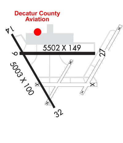
| Lat: N 3058.3 Long: W 08438.2 Elev: 141 Var: +04 Longest Runway: 5502 | ||
| Clr Del: 124.775 AWOS: 121.12 CTAF: 122.97 | ||
| |||||||||||||||||||||||||||||||||||||||||||||||||||||||||||||||||||||
| |||||||||||||||||||||||||||||||||||||||||||||||||||||||||||||||||||||
| |||||||||||||||||||||||||||||||||||||||||||||||||||||||||||||||||||||
| Rwy | Rwy | |||||||
| 5502x149 | 5502' | 5502x149 | 5502' | 111.35 - 273° | ||||
| 5003x100 | 5003' | 5003x100 | 5003' | |||||
| Runway ID | Single Wheel | Double Wheel | Double Tandem Wheel | Dual Double Wheel |
| 09/27 | 24,000 | N/A | N/A | N/A |
| 14/32 | 24,000 | N/A | N/A | N/A |
| These numbers are Advisory and are not limits. The Airport Manager should have more accurate Weight Limits | ||||
 Airport Diagram might not be current. | |
| Facility Name: | DECATUR COUNTY INDUSTRIAL AIR PARK |
| City Name: | BAINBRIDGE |
| County: | DECATUR |
| State abbrev: | GA |
| State Name: | GEORGIA |
| Ownership: | PUBLICLY OWNED |
| Use: | OPEN TO THE PUBLIC |
| Owner's Name: | DECATUR COUNTY |
| Address: | PO BOX 726 |
| BAINBRIDGE, GA 39818 | |
| Owner's Phone: | 229-248-2103 |
| Manager's Name: | TOMMY JOHNSON |
| Address: | 413 4TH RAMP |
| BAINBRIDGE, GA 39817 | |
| Phone: | 229-416-7776 |
| FAA Region: | SOUTHERN |
| FAA Field Office: | ATL |
| Date | Sunrise | Sunset |
|---|---|---|
| 04/17/24 Wednesday | 7:08 | 20:09 |
| 04/18/24 Thursday | 7:07 | 20:09 |
| 04/19/24 Friday | 7:06 | 20:10 |
| 04/20/24 Saturday | 7:04 | 20:11 |
| 04/21/24 Sunday | 7:03 | 20:11 |
| 04/22/24 Monday | 7:02 | 20:12 |
| 04/23/24 Tuesday | 7:01 | 20:13 |
| 04/24/24 Wednesday | 7:00 | 20:13 |
| 04/25/24 Thursday | 6:59 | 20:14 |
| 04/26/24 Friday | 6:58 | 20:15 |
| 04/27/24 Saturday | 6:57 | 20:15 |
| 04/28/24 Sunday | 6:56 | 20:16 |
| 04/29/24 Monday | 6:55 | 20:17 |
| 04/30/24 Tuesday | 6:54 | 20:17 |
| Airport Attendance Schedule | 7 Days A Week 0800-1800 |
| Airport Status | OPERATIONAL (This Status can change at any time - please check NOTAMS) |
| Airport Lighting Schedule | PAPI RWY 09 & 27 OPR CONSLY DUSK-2200. HIRL RWY 09/27 PRESET MED INTST DUSK-2200; TO INCR INTST - CTAF. AFTER 2200, ACTVT PAPI RWY 09 &27; HIRL RWY 09/27 - CTAF. MALSR RWY 27 - CTAF. |
| Airport Storage Available | Tie Downs, Hanger |
| Extra Services Available | Crop Dusting, Flight Instruction, Aircraft Rental |
| Wind Indicator | YES - (lighted) |
| Control Tower | NO |
| CTAF Frequency | 122.975; ALL ACFT OPERATING LOCALLY AT BGE MUST HAVE A TWO-WAY RADIO CAPABLE OF TRANSMITTING/RECEIVING ON CTAF FREQ; ONE-STOP TRANSIENT ACFT ARE EXEMPT FROM THIS REQUIREMENT. |
| Unicom Frequency | 122.975 |
| Rotating Beacon Color | WG |
| Segmented Circle | YES |
| Landing Fee | NO |
| Airport Inspected | STATE - performed by STATE AERONAUTICAL PERSONNEL |
| Inspection Date | 01/04/2024 |
| Type of Fuel Available | Grade 100LL, JET A; -10SELF SVC FUEL 24 HRS WITH CREDIT CARD. |
| Airframe Repair Service | MINOR |
| Power Plant Repair Service | MINOR |
| Latitude | N3058.3 |
| Longitude | W08438.2 (ESTIMATED) |
| Arpt Elevation | 141ft (SURVEYED) |
| Magnetic Variation | 04W |
| 6 miles NW | of BAINBRIDGE |
| Traffic Pattern Altitude | |
| Sectional Chart | JACKSONVILLE |
| Operations (Reported) | Yearly | Avg. Daily |
|---|---|---|
| General Aviation Transient | 7100 | 19 |
| General Aviation Local | 10000 | 27 |
| Air Taxi | 0 | 0 |
| Commerical | 0 | 0 |
| Commuter | 0 | 0 |
| Military | 250 | 1 |
| Aircraft based on Field | |
|---|---|
| General Aviation Singles | 33 |
| General Aviation Multi | 1 |
| Jet Aircraft | 0 |
| General Aviation Helicopters | 0 |
| Military Aircraft | 0 |
| Gliders | 0 |
| Ultralights | 0 |
| FSS on field | NO |
| FSS tie-in | MACON |
| FSS Phone | 1-800-WX-BRIEF |
| Who issues Notams | MCN |
| Notam D service at airport | YES |
| ARTCC Name | JACKSONVILLE |
| Airport Certification | |
| Aircraft Rescue & Firefighting Index | None |
| Airport of Entry | No |
| Custom Landing Rights | No |
| Joint Civil/Military | No |
| Military Landing rights | YES |
| NATIONAL PLAN OF INTEGRATED AIRPORT SYSTEMS (NPIAS) |
| EXTENSIVE STUDENT PILOT TRNG ON AND INVOF ARPT. |
| FOR CD IF UNA ON FREQ CTC TALLAHASSEE APCH AT 850-942-8311. WHEN APCH CLSD, CTC JACKSONVILLE ARTCC AT 904-845-1592. |
Airport Communications & Frequencies:
| |||||||||||||||||||||
| Runway: 09 | Runway: 27 | ||
| Mag heading: | 94° | Mag heading: | 274° |
| Rwy Slope: | -.23% Down | Rwy Slope: | .23% Up |
| Approach: | Approach: | LOC/GS | |
| Pattern: | Left Traffic | Pattern: | Left Traffic |
| Markings: | PRECISION INSTRUMENT | Markings: | PRECISION INSTRUMENT |
| Marking Condition: | GOOD | Marking Condition: | GOOD |
| Arresting Dev: | Arresting Dev: | ||
| Lat & Long: | N3058.4 W08438.6 | Lat. & Long.: | N3058.4 W08437.5 |
| Elev: | 141.3 ft. MSL | Elev: | 128.8 ft. MSL |
| TCH: | 40 ft. AGL | TCH: | 39 ft. AGL |
| Visual Glide Path: | 3.00 degrees | Visual Glide Path: | 3.00 degrees |
| Displaced Threshold: | No | Displaced Threshold: | No |
| Touchdown Zone: | YES | Touchdown Zone: | YES |
| Touchdown Elev.: | 141.3 feet | Touchdown Elev.: | 134.4 feet |
| Visual Glide Slope: | 2-Light PAPI on LEFT side of Runway | Visual Glide Slope: | 2-Light PAPI on LEFT side of Runway; RWY 27 PAPI UNUSBL BYD 8 DEG RIGHT OF RCL. |
| RVR Equipment: | RVR Equipment: | ||
| RVV Equipment: | NO | RVV Equipment: | NO |
| Approach Lights: | Approach Lights: | MALSR - 1,400 foot medium intensity approach lighting system with runway alignment indicator lights | |
| REIL: | NO | REIL: | NO |
| Centerline Lights: | NO | Centerline Lights: | NO |
| Touchdown lights: | NO | Touchdown lights: | NO |
| Runway Category: | Runway with a Non-precision Approach having visibility minimums greater than 3/4 mile | Runway Category: | Precision Instrument Runway |
| Declared Distances: | Declared Distances: | ||
| Obstructions: | TREES | Obstructions: | TREES |
| Marked: | NOT Marked/Lighted | Marked: | NOT Marked/Lighted |
| Clearance slope: | 25:1 | Clearance slope: | 46:1 |
| Obstruction height: | 51 feet AGL | Obstruction height: | 93 feet AGL |
| Dist. from runway: | 1475 feet | Dist. from runway: | 4478 feet |
| Centerline offset: | 557 left of centerline | Centerline offset: | 606 feet left of centerline |
| Comments: | Comments: |
| Runway: 14 | Runway: 32 | ||
| Mag heading: | 143° | Mag heading: | 323° |
| Rwy Slope: | -.03% Down | Rwy Slope: | .03% Up |
| Approach: | Approach: | ||
| Pattern: | Left Traffic | Pattern: | Left Traffic |
| Markings: | BASIC | Markings: | BASIC |
| Marking Condition: | FAIR | Marking Condition: | FAIR |
| Arresting Dev: | Arresting Dev: | ||
| Lat & Long: | N3058.5 W08438.7 | Lat. & Long.: | N3057.9 W08438.1 |
| Elev: | 135.0 ft. MSL | Elev: | 133.6 ft. MSL |
| TCH: | TCH: | ||
| Visual Glide Path: | Visual Glide Path: | ||
| Displaced Threshold: | No | Displaced Threshold: | No |
| Touchdown Zone: | YES | Touchdown Zone: | YES |
| Touchdown Elev.: | 140.5 feet | Touchdown Elev.: | 140.3 feet |
| Visual Glide Slope: | Visual Glide Slope: | ||
| RVR Equipment: | RVR Equipment: | ||
| RVV Equipment: | NO | RVV Equipment: | NO |
| Approach Lights: | Approach Lights: | ||
| REIL: | NO | REIL: | NO |
| Centerline Lights: | NO | Centerline Lights: | NO |
| Touchdown lights: | NO | Touchdown lights: | NO |
| Runway Category: | Runway with a Visual Approach | Runway Category: | Runway with a Visual Approach |
| Declared Distances: | Declared Distances: | ||
| Obstructions: | Obstructions: | TREES | |
| Marked: | Marked: | NOT Marked/Lighted | |
| Clearance slope: | 50:1 | Clearance slope: | 15:1 |
| Obstruction height: | Obstruction height: | 62 feet AGL | |
| Dist. from runway: | Dist. from runway: | 1130 feet | |
| Centerline offset: | Centerline offset: | 86 feet left of centerline | |
| Comments: | Comments: |
Thanks for using FltPlan.com
all rights reserved © 1999-2024 by Flight Plan LLC