
| IGOR I SIKORSKY MEMORIAL BRIDGEPORT CT |
| |
| Lat: N 4109.8 Long: W 07307.6 Elev: 9 Var: +13 Longest Runway: 4759 | ||
| Clr Del: 124.07 TW CLD Dept. ATIS: 119.15 Arr. ATIS: 119.15 Ground: 121.75 Tower: 120.9 | ||
| ||||||||||||||||||||||||||||||||||||||||||||||||||||||||||||||||||||
| ||||||||||||||||||||||||||||||||||||||||||||||||||||||||||||||||||||
| ||||||||||||||||||||||||||||||||||||||||||||||||||||||||||||||||||||
| ||||||||||||||||||||||||||||||||||||||||||||||||||||||||||||||||||||
| Rwy | Rwy | |||||||
| 4677x100 | 4677' | 110.70 - 060° | 4677x100 | 4357' | ||||
| 4759x150 | 4759' | 4759x150 | 4395' | |||||
| Runway ID | Single Wheel | Double Wheel | Double Tandem Wheel | Dual Double Wheel |
| 06/24 | 57,000 | 80,000 | N/A | N/A |
| 11/29 | 30,000 | 108,000 | N/A | N/A |
| These numbers are Advisory and are not limits. The Airport Manager should have more accurate Weight Limits | ||||
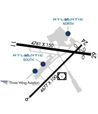 Airport Diagram might not be current. | |
| Facility Name: | BRIDGEPORT/SIKORSKY |
| City Name: | BRIDGEPORT |
| County: | FAIRFIELD |
| State abbrev: | CT |
| State Name: | CONNECTICUT |
| Ownership: | PUBLICLY OWNED |
| Use: | OPEN TO THE PUBLIC |
| Owner's Name: | CITY OF BRIDGEPORT |
| Address: | 45 LYON TERRACE |
| BRIDGEPORT, CT 06615 | |
| Owner's Phone: | 203-576-7201 |
| Manager's Name: | MICHELLE MUOIO |
| Address: | 1000 GREAT MEADOW RD |
| STRATFORD, CT 06497 | |
| Phone: | 203-576-8163 |
| FAA Region: | NEW ENGLAND |
| FAA Field Office: | NONE |
| Date | Sunrise | Sunset |
|---|---|---|
| 04/18/24 Thursday | 6:07 | 19:37 |
| 04/19/24 Friday | 6:06 | 19:38 |
| 04/20/24 Saturday | 6:05 | 19:39 |
| 04/21/24 Sunday | 6:03 | 19:40 |
| 04/22/24 Monday | 6:02 | 19:41 |
| 04/23/24 Tuesday | 6:00 | 19:42 |
| 04/24/24 Wednesday | 5:59 | 19:43 |
| 04/25/24 Thursday | 5:57 | 19:44 |
| 04/26/24 Friday | 5:56 | 19:45 |
| 04/27/24 Saturday | 5:55 | 19:46 |
| 04/28/24 Sunday | 5:53 | 19:47 |
| 04/29/24 Monday | 5:52 | 19:48 |
| 04/30/24 Tuesday | 5:51 | 19:49 |
| 05/01/24 Wednesday | 5:49 | 19:50 |
| Airport Attendance Schedule | 7 Days A Week 0600-2400 |
| Airport Status | OPERATIONAL (This Status can change at any time - please check NOTAMS) |
| Airport Lighting Schedule | WHEN ATCT CLSD, ACTVT REIL RWY 06 & 24, 11 & 29; PAPI RWY 06, 11 & 29; HIRL RWY 06/24 & 11/29 - CTAF. |
| Airport Storage Available | Tie Downs, Hanger |
| Extra Services Available | Air Freight, Air Ambulance, Avionics, Charter, Flight Instruction, Aircraft Rental, Aircraft Sales |
| Wind Indicator | YES - (lighted) |
| Control Tower | YES |
| CTAF Frequency | 120.900 |
| Unicom Frequency | 123.000 |
| Rotating Beacon Color | WG |
| Segmented Circle | YES |
| Landing Fee | YES; PRKG FEE ALL ACFT AFT 2 HRS. LDG FEE ALL ACFT EXC SOLO STUDENTS. |
| Airport Inspected | FEDERAL - performed by FAA AIRPORTS FIELD PERSONNEL |
| Inspection Date | 06/23/2022 |
| Type of Fuel Available | Grade 100LL, JET A (freeze point -40C) |
| Airframe Repair Service | MAJOR |
| Power Plant Repair Service | MAJOR |
| Latitude | N4109.8 |
| Longitude | W07307.6 (ESTIMATED) |
| Arpt Elevation | 8ft (SURVEYED) |
| Magnetic Variation | 13W |
| 3 miles SE | of BRIDGEPORT |
| Traffic Pattern Altitude | SNGL ENG ACFT 1000 FT AGL; ALL OTHERS 1500 FT AGL. |
| Sectional Chart | NEW YORK |
| Operations (Reported) | Yearly | Avg. Daily |
|---|---|---|
| General Aviation Transient | 21369 | 59 |
| General Aviation Local | 35231 | 97 |
| Air Taxi | 3709 | 10 |
| Commerical | 4 | 0 |
| Commuter | 0 | 0 |
| Military | 233 | 1 |
| Aircraft based on Field | |
|---|---|
| General Aviation Singles | 107 |
| General Aviation Multi | 10 |
| Jet Aircraft | 27 |
| General Aviation Helicopters | 10 |
| Military Aircraft | 0 |
| Gliders | 1 |
| Ultralights | 0 |
| FSS on field | NO |
| FSS tie-in | BRIDGEPORT |
| FSS Phone | 1-800-WX-BRIEF |
| Who issues Notams | BDR |
| Notam D service at airport | YES |
| ARTCC Name | NEW YORK |
| Airport Certification | |
| Aircraft Rescue & Firefighting Index | AIRPORT HAS A CERTIFICATE UNDER CFR PART 139 |
| Airport of Entry | No |
| Custom Landing Rights | YES |
| Joint Civil/Military | No |
| Military Landing rights | YES |
| NATIONAL PLAN OF INTEGRATED AIRPORT SYSTEMS (NPIAS) |
| GRANT AGREEMENTS UNDER FAAP/ADAP/AIP |
| CONVEYANCE UNDER SCETION 16, FEDERAL AIRPORT ACT OF 1946 OR SECTION 23, AIRPORT AND AIRWAY DEVELOPMENT ACT OF 1970 |
| SURPLUS PROPERTY AGREEMENT UNDER PUBLIC LAW 289 |
| ASSURANCES PURSUANT TO TITLE VI, CIVIL RIGHTS ACT OF 1964 |
| AGREEMENT UNDER DLAND OR DCLA HAS EXPIRED. |
| THERE MAY BE STANDING WATER ADJ TO ALL SFCS. |
| AVOID OVERFLYING RESL AREAS NE & SE OF ARPT. DEPARTING RWY 24 AVOID TURNS TIL 1/2 MILE BYD SHORELINE. |
| WHEN ATCT CLSD ALL ENG RUNUPS ARE PROHIBITED. HWVR, IF AN ACFT RQRS NIGHTTIME ENG MAINT, PPR FM AMGR IS RQRD AND RUNUPS ARE TO BE PERFORMED ON TWY G BTWN J & K. PILOTS ARE ADZD TO USE CARE PSNG THEIR ACFT TO PREVENT DMG FM PROP WASH TO AFLD SIGN. |
| UNEVEN SFCS RWY 29 SAFETY AREA APCH END LEFT SIDE. |
| RWY 11/29 CLSD TO ALL ACR OPNS. |
| POLE 120 FT .75 NM S OF ARPT UNLGTD. |
| ARPT CLSD TO SKED ACRS MORE THAN 10 PSGRS AND UNSKED ACRS MORE THAN 30 PSGRS EXC 90 DAY PPR. |
| RWY 29 CLSD TO TKOF ACFT MORE THAN 45000 LB EXC 30 MIN PPR 203-576-7497. |
| FOR CD WHEN ATCT CLSD CTC NEW YORK APCH AT 516-683-2449 OR 124.075 |
| EXTSV HOP BLW 10000 FT 5-15 MI NW THRU NE, FOR TFC INFO WHEN INVOF ARPT CTC SIKORSKY OPS ON 133.6/305.8 (0700-1630). |
| WHEN WINDS ARE LESS THAN 5 KTS RQSTD USE OF RWY 11 OR 29. |
| BIRDS & WILDLIFE FQTLY ON & INVOF ARPT. |
| RWY 11/2 9 NOT AVBL FOR SKEDD ACR OPS MORE THAN 9 PAX SEATS OR UNSKED ACR OPS AT LEAST 31 PAX SEATS. |
Airport Communications & Frequencies:
| ||||||||||||||||||||||||||||
| Runway: 06 | Runway: 24 | ||
| Mag heading: | 58° | Mag heading: | 238° |
| Rwy Slope: | .00% Down | Rwy Slope: | .00% Up |
| Approach: | ILS/DME | Approach: | |
| Pattern: | Left Traffic | Pattern: | Left Traffic |
| Markings: | PRECISION INSTRUMENT | Markings: | NONPRECISION INSTRUMENT |
| Marking Condition: | GOOD | Marking Condition: | GOOD |
| Arresting Dev: | EMAS | Arresting Dev: | |
| Lat & Long: | N4109.4 W07307.9 | Lat. & Long.: | N4110.0 W07307.2 |
| Elev: | 6.9 ft. MSL | Elev: | 6.7 ft. MSL |
| TCH: | 51 ft. AGL | TCH: | 52 ft. AGL |
| Visual Glide Path: | 3.00 degrees | Visual Glide Path: | 3.00 degrees |
| Displaced Threshold: | No | Displaced Threshold: | 320 feet |
| Touchdown Zone: | YES | Touchdown Zone: | YES |
| Touchdown Elev.: | 6.9 feet | Touchdown Elev.: | 6.8 feet |
| Visual Glide Slope: | 4-Light PAPI on RIGHT side of Runway | Visual Glide Slope: | 4-Light PAPI on LEFT side of Runway |
| RVR Equipment: | RVR Equipment: | ||
| RVV Equipment: | NO | RVV Equipment: | NO |
| Approach Lights: | Approach Lights: | ||
| REIL: | YES | REIL: | YES |
| Centerline Lights: | NO | Centerline Lights: | NO |
| Touchdown lights: | NO | Touchdown lights: | NO |
| Runway Category: | Precision Instrument Runway | Runway Category: | Runway with a Non-precision Approach having visibility minimums greater than 3/4 mile |
| Declared Distances: | TORA:4677' TODA:4677' ASDA:4677' LDA:4677' | Declared Distances: | TORA:4677' TODA:4677' ASDA:4677' LDA:4357' |
| Obstructions: | ROAD | Obstructions: | ROAD |
| Marked: | NOT Marked/Lighted | Marked: | LIGHTED |
| Clearance slope: | 14:1 | Clearance slope: | 1:1; APCH RATIO 34:1 TO DTHR. |
| Obstruction height: | 19 feet AGL | Obstruction height: | 19 feet AGL |
| Dist. from runway: | 480 feet | Dist. from runway: | 200 feet |
| Centerline offset: | 525 left of centerline | Centerline offset: | 150 feet left of centerline |
| Comments: | Comments: |
| Runway: 11 | Runway: 29 | ||
| Mag heading: | 111° | Mag heading: | 291° |
| Rwy Slope: | -.04% Down | Rwy Slope: | .04% Up |
| Approach: | Approach: | ||
| Pattern: | Left Traffic | Pattern: | Right Traffic |
| Markings: | BASIC | Markings: | NONPRECISION INSTRUMENT |
| Marking Condition: | FAIR | Marking Condition: | FAIR |
| Arresting Dev: | Arresting Dev: | ||
| Lat & Long: | N4110.0 W07308.1 | Lat. & Long.: | N4109.9 W07307.1 |
| Elev: | 8.5 ft. MSL | Elev: | 6.5 ft. MSL |
| TCH: | 40 ft. AGL | TCH: | 55 ft. AGL |
| Visual Glide Path: | 3.50 degrees | Visual Glide Path: | 3.00 degrees |
| Displaced Threshold: | No | Displaced Threshold: | 364 feet |
| Touchdown Zone: | YES | Touchdown Zone: | YES |
| Touchdown Elev.: | 8.5 feet | Touchdown Elev.: | 6.9 feet |
| Visual Glide Slope: | 4-Light PAPI on LEFT side of Runway | Visual Glide Slope: | 4-Light PAPI on LEFT side of Runway |
| RVR Equipment: | RVR Equipment: | ||
| RVV Equipment: | NO | RVV Equipment: | NO |
| Approach Lights: | Approach Lights: | ||
| REIL: | YES | REIL: | YES |
| Centerline Lights: | NO | Centerline Lights: | NO |
| Touchdown lights: | NO | Touchdown lights: | NO |
| Runway Category: | Runway with a Visual Approach | Runway Category: | Runway with a Non-precision Approach having visibility minimums greater than 3/4 mile |
| Declared Distances: | TORA:4759' TODA:4759' ASDA:4759' LDA:4759' | Declared Distances: | TORA:4759' TODA:4759' ASDA:4759' LDA:4395' |
| Obstructions: | TREES | Obstructions: | ROAD |
| Marked: | NOT Marked/Lighted | Marked: | LIGHTED |
| Clearance slope: | 8:1 | Clearance slope: | APCH RATIO 20:1 TO DTHR. |
| Obstruction height: | 35 feet AGL | Obstruction height: | 15 feet AGL |
| Dist. from runway: | 500 feet | Dist. from runway: | 200 feet |
| Centerline offset: | 120 left of centerline | Centerline offset: | |
| Comments: | Comments: |
Thanks for using FltPlan.com
all rights reserved © 1999-2024 by Flight Plan LLC


