| ARTESIA MUNI ARTESIA NM |
| |
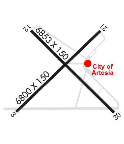
| Lat: N 3251.1 Long: W 10428.1 Elev: 3545 Var: -09 Longest Runway: 6800 | ||
| AWOS: 126.72 CTAF: 123.07 | ||
| ||||||||||||||||||||||||||||||||||||||||||||||||||||||||||||||||||||
| ||||||||||||||||||||||||||||||||||||||||||||||||||||||||||||||||||||
| ||||||||||||||||||||||||||||||||||||||||||||||||||||||||||||||||||||
| Rwy | Rwy | |||||||
| 6800x150 | 6301' | 6800x150 | 6800' | |||||
| 6132x100 | 6132' | 6132x100 | 6132' | |||||
| Runway ID | Single Wheel | Double Wheel | Double Tandem Wheel | Dual Double Wheel |
| 04/22 | 40,000 | 57,000 | N/A | N/A |
| 13/31 | 40,000 | 57,000 | N/A | N/A |
| These numbers are Advisory and are not limits. The Airport Manager should have more accurate Weight Limits | ||||
 Airport Diagram might not be current. | |
| Facility Name: | ARTESIA MUNI |
| City Name: | ARTESIA |
| County: | EDDY |
| State abbrev: | NM |
| State Name: | NEW MEXICO |
| Ownership: | PUBLICLY OWNED |
| Use: | OPEN TO THE PUBLIC |
| Owner's Name: | CITY OF ARTESIA |
| Address: | 702 AIRPORT RD |
| ARTESIA, NM 88210 | |
| Owner's Phone: | 575-746-2122 |
| Manager's Name: | LANCE GOODRICH |
| Address: | PO BOX 1310 |
| ARTESIA, NM 88211 | |
| Phone: | 575-748-3206 |
| FAA Region: | SOUTHWEST |
| FAA Field Office: | LNM |
| Date | Sunrise | Sunset |
|---|---|---|
| 09/24/21 Friday | 6:47 | 18:52 |
| 09/25/21 Saturday | 6:48 | 18:51 |
| 09/26/21 Sunday | 6:49 | 18:49 |
| 09/27/21 Monday | 6:49 | 18:48 |
| 09/28/21 Tuesday | 6:50 | 18:47 |
| 09/29/21 Wednesday | 6:51 | 18:45 |
| 09/30/21 Thursday | 6:51 | 18:44 |
| 10/01/21 Friday | 6:52 | 18:43 |
| 10/02/21 Saturday | 6:53 | 18:41 |
| 10/03/21 Sunday | 6:53 | 18:40 |
| 10/04/21 Monday | 6:54 | 18:39 |
| 10/05/21 Tuesday | 6:55 | 18:37 |
| 10/06/21 Wednesday | 6:55 | 18:36 |
| 10/07/21 Thursday | 6:56 | 18:35 |
| Airport Attendance Schedule | 7 Days A Week 0700-1700, EXCEPT MAJOR HOLS. |
| Airport Status | OPERATIONAL (This Status can change at any time - please check NOTAMS) |
| Airport Lighting Schedule | ACTVT MIRL RWY 04/22 & 13/31 - CTAF. |
| Airport Storage Available | Tie Downs, Hanger |
| Extra Services Available | NONE |
| Wind Indicator | YES - (lighted) |
| Control Tower | NO |
| CTAF Frequency | 123.075 |
| Unicom Frequency | 123.075 |
| Rotating Beacon Color | CLEAR-GREEN (Light Land Airport) |
| Segmented Circle | YES |
| Landing Fee | NO |
| Airport Inspected | STATE - performed by PRIVATE CONTRACT PERSONNEL |
| Inspection Date | 04/09/2020 |
| Type of Fuel Available | Grade 100LL, JET A-1 (freeze point -50C); -10FUEL ON CALL AFT HRS CALL 575-748-3206. FEE CHARGED. |
| Airframe Repair Service | None |
| Power Plant Repair Service | None |
| Latitude | N3251.1 |
| Longitude | W10428.1 (ESTIMATED) |
| Arpt Elevation | 3544ft (SURVEYED) |
| Magnetic Variation | 09E |
| 3 miles W | of ARTESIA |
| Traffic Pattern Altitude | |
| Sectional Chart | ALBUQUERQUE |
| Operations (Reported) | Yearly | Avg. Daily |
|---|---|---|
| General Aviation Transient | 7150 | 20 |
| General Aviation Local | 4400 | 12 |
| Air Taxi | 0 | 0 |
| Commerical | 0 | 0 |
| Commuter | 0 | 0 |
| Military | 2500 | 7 |
| Aircraft based on Field | |
|---|---|
| General Aviation Singles | 21 |
| General Aviation Multi | 4 |
| Jet Aircraft | 1 |
| General Aviation Helicopters | 0 |
| Military Aircraft | 0 |
| Gliders | 0 |
| Ultralights | 0 |
| FSS on field | NO |
| FSS tie-in | ALBUQUERQUE |
| FSS Phone | 1-800-WX-BRIEF |
| Who issues Notams | ATS |
| Notam D service at airport | YES |
| ARTCC Name | ALBUQUERQUE |
| Airport Certification | |
| Aircraft Rescue & Firefighting Index | None |
| Airport of Entry | No |
| Custom Landing Rights | No |
| Joint Civil/Military | No |
| Military Landing rights | YES |
| NATIONAL PLAN OF INTEGRATED AIRPORT SYSTEMS (NPIAS) |
| GRANT AGREEMENTS UNDER FAAP/ADAP/AIP |
| ASSURANCES PURSUANT TO TITLE VI, CIVIL RIGHTS ACT OF 1964 |
| AGREEMENT UNDER DLAND OR DCLA HAS EXPIRED. |
| EMERG ACFT REPAIR AVBL. |
| FOR CD CTC ALBUQUERQUE ARTCC AT 505-856-4861. |
Airport Communications & Frequencies:
| |||||||||||||||||
| Runway: 04 | Runway: 22 | ||
| Mag heading: | 36° | Mag heading: | 216° |
| Rwy Slope: | -.37% Down | Rwy Slope: | .37% Up |
| Approach: | Approach: | ||
| Pattern: | Left Traffic | Pattern: | Left Traffic |
| Markings: | BASIC | Markings: | NONPRECISION INSTRUMENT |
| Marking Condition: | GOOD | Marking Condition: | GOOD |
| Arresting Dev: | Arresting Dev: | ||
| Lat & Long: | N3250.7 W10428.6 | Lat. & Long.: | N3251.5 W10427.6 |
| Elev: | 3544.5 ft. MSL | Elev: | 3519.5 ft. MSL |
| TCH: | TCH: | 25 ft. AGL | |
| Visual Glide Path: | Visual Glide Path: | 3.00 degrees | |
| Displaced Threshold: | 499 feet | Displaced Threshold: | No |
| Touchdown Zone: | YES | Touchdown Zone: | YES |
| Touchdown Elev.: | 3541.3 feet | Touchdown Elev.: | 3521.9 feet |
| Visual Glide Slope: | Visual Glide Slope: | PULSATING/STEADY BURNING VASI ON LEFT SIDE OF RUNWAY; RWY 22 PSIL OUT OF SERVICE INDEFINITELY. | |
| RVR Equipment: | RVR Equipment: | ||
| RVV Equipment: | NO | RVV Equipment: | NO |
| Approach Lights: | Approach Lights: | ||
| REIL: | NO | REIL: | NO |
| Centerline Lights: | NO | Centerline Lights: | NO |
| Touchdown lights: | NO | Touchdown lights: | NO |
| Runway Category: | Runway with a Visual Approach | Runway Category: | Runway with a Visual Approach |
| Declared Distances: | Declared Distances: |
| Runway: 13 | Runway: 31 | ||
| Mag heading: | 126° | Mag heading: | 306° |
| Rwy Slope: | -.44% Down | Rwy Slope: | .44% Up |
| Approach: | Approach: | ||
| Pattern: | Left Traffic | Pattern: | Left Traffic |
| Markings: | PRECISION INSTRUMENT | Markings: | PRECISION INSTRUMENT |
| Marking Condition: | GOOD | Marking Condition: | GOOD |
| Arresting Dev: | Arresting Dev: | ||
| Lat & Long: | N3251.5 W10428.4 | Lat. & Long.: | N3250.8 W10427.6 |
| Elev: | 3533.5 ft. MSL | Elev: | 3506.3 ft. MSL |
| TCH: | 40 ft. AGL | TCH: | 40 ft. AGL |
| Visual Glide Path: | 3.00 degrees | Visual Glide Path: | 3.00 degrees |
| Displaced Threshold: | No | Displaced Threshold: | No |
| Touchdown Zone: | YES | Touchdown Zone: | YES |
| Touchdown Elev.: | 3533.7 feet | Touchdown Elev.: | 3519.9 feet |
| Visual Glide Slope: | 4-Light PAPI on LEFT side of Runway | Visual Glide Slope: | 4-Light PAPI on LEFT side of Runway |
| RVR Equipment: | RVR Equipment: | ||
| RVV Equipment: | NO | RVV Equipment: | NO |
| Approach Lights: | Approach Lights: | ||
| REIL: | NO | REIL: | NO |
| Centerline Lights: | NO | Centerline Lights: | NO |
| Touchdown lights: | NO | Touchdown lights: | NO |
| Runway Category: | Runway with a Non-precision Approach having visibility minimums greater than 3/4 mile | Runway Category: | Runway with a Non-precision Approach having visibility minimums greater than 3/4 mile |
| Declared Distances: | Declared Distances: | ||
| Obstructions: | BRUSH | Obstructions: | |
| Marked: | NOT Marked/Lighted | Marked: | |
| Clearance slope: | 21:1 | Clearance slope: | 50:1 |
| Obstruction height: | 7 feet AGL | Obstruction height: | |
| Dist. from runway: | 350 feet | Dist. from runway: | |
| Centerline offset: | Centerline offset: | ||
| Comments: | Comments: |
Thanks for using FltPlan.com
all rights reserved © 1999-2021 by Flight Plan LLC