| WATERTOWN INTL WATERTOWN NY |
| |
| Lat: N 4359.5 Long: W 07601.2 Elev: 331 Var: +12 Longest Runway: 7001 | ||
| Clr Del: 120.8 AWOS: 132.32 CTAF: 123.0 | ||
| |||||||||||||||||||||||||||||||||||||||||||||||||||||||||||||||||||||
| |||||||||||||||||||||||||||||||||||||||||||||||||||||||||||||||||||||
| |||||||||||||||||||||||||||||||||||||||||||||||||||||||||||||||||||||
| Rwy | Rwy | |||||||
| 4999x150 | 4999' | 111.10 - 065° | 4999x150 | 4999' | ||||
| 7001x150 | 7001' | 7001x150 | 7001' | |||||
| Runway ID | Single Wheel | Double Wheel | Double Tandem Wheel | Dual Double Wheel |
| 07/25 | 105,000 | 147,000 | 244,000 | N/A |
| 10/28 | 109,000 | 154,000 | 254,000 | N/A |
| These numbers are Advisory and are not limits. The Airport Manager should have more accurate Weight Limits | ||||
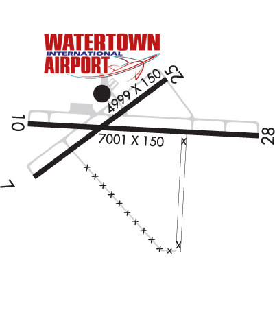 Airport Diagram might not be current. | |
| Facility Name: | WATERTOWN INTL |
| City Name: | WATERTOWN |
| County: | JEFFERSON |
| State abbrev: | NY |
| State Name: | NEW YORK |
| Ownership: | PUBLICLY OWNED |
| Use: | OPEN TO THE PUBLIC |
| Owner's Name: | COUNTY OF JEFFERSON |
| Address: | 195 ARSENAL ST. |
| WATERTOWN, NY 13601 | |
| Owner's Phone: | 315-785-3075 |
| Manager's Name: | GRANT W. SUSSEY |
| Address: | BLDG 22529 AIRPORT DR |
| DEXTER, NY 13634-3062 | |
| Phone: | 315-786-6002 |
| FAA Region: | EASTERN |
| FAA Field Office: | NYC |

| Date | Sunrise | Sunset |
|---|---|---|
| 09/24/21 Friday | 6:53 | 18:58 |
| 09/25/21 Saturday | 6:54 | 18:56 |
| 09/26/21 Sunday | 6:56 | 18:55 |
| 09/27/21 Monday | 6:57 | 18:53 |
| 09/28/21 Tuesday | 6:58 | 18:51 |
| 09/29/21 Wednesday | 6:59 | 18:49 |
| 09/30/21 Thursday | 7:00 | 18:47 |
| 10/01/21 Friday | 7:01 | 18:45 |
| 10/02/21 Saturday | 7:03 | 18:44 |
| 10/03/21 Sunday | 7:04 | 18:42 |
| 10/04/21 Monday | 7:05 | 18:40 |
| 10/05/21 Tuesday | 7:06 | 18:38 |
| 10/06/21 Wednesday | 7:07 | 18:36 |
| 10/07/21 Thursday | 7:09 | 18:35 |
| Airport Attendance Schedule | OCT THRU APRIL 7 Days A Week 0600-1800, MAY THRU SEPT 7 Days A Week 0500-1900 |
| Airport Status | OPERATIONAL (This Status can change at any time - please check NOTAMS) |
| Airport Lighting Schedule | ACTVT HIRL RY 07/25; MIRL RY 10/28; MALSR RYS 07; PAPI RY 10 & RY 28; REIL RY 28 & TWY LGTS - CTAF. |
| Airport Storage Available | Tie Downs, Hanger |
| Extra Services Available | Cargo Handling, Flight Instruction, Aircraft Rental |
| Wind Indicator | YES - (lighted) |
| Control Tower | NO |
| CTAF Frequency | 123.000 |
| Unicom Frequency | 123.000 |
| Rotating Beacon Color | CLEAR-GREEN (Light Land Airport) |
| Segmented Circle | NO |
| Landing Fee | NO; LANDING FEE FOR ACFT OVER 6000 LBS GWT. |
| Airport Inspected | FEDERAL - performed by FAA AIRPORTS FIELD PERSONNEL |
| Inspection Date | 08/17/2020 |
| Type of Fuel Available | Grade 100LL, JET A (freeze point -40C) |
| Airframe Repair Service | MAJOR |
| Power Plant Repair Service | MAJOR |
| Latitude | N4359.5 |
| Longitude | W07601.2 (ESTIMATED) |
| Arpt Elevation | 330ft (SURVEYED) |
| Magnetic Variation | 12W |
| 5 miles W | of WATERTOWN |
| Traffic Pattern Altitude | |
| Sectional Chart | NEW YORK |
| Operations (Reported) | Yearly | Avg. Daily |
|---|---|---|
| General Aviation Transient | 5030 | 14 |
| General Aviation Local | 27750 | 76 |
| Air Taxi | 1200 | 3 |
| Commerical | 1456 | 4 |
| Commuter | 0 | 0 |
| Military | 14350 | 39 |
| Aircraft based on Field | |
|---|---|
| General Aviation Singles | 24 |
| General Aviation Multi | 8 |
| Jet Aircraft | 1 |
| General Aviation Helicopters | 2 |
| Military Aircraft | 0 |
| Gliders | 0 |
| Ultralights | 0 |
| FSS on field | NO |
| FSS tie-in | BURLINGTON |
| FSS Phone | 1-800-WX-BRIEF |
| Who issues Notams | ART |
| Notam D service at airport | YES |
| ARTCC Name | BOSTON |
| Airport Certification | AIRPORT RECEIVING SCHEDULED AIR CARRIER SERVICE FROM CARRIERS CERTIFICATED BY THE CIVIL AERONAUTICS BOARD; PPR 2 HRS FOR UNSKD OPS WITH MORE THAN 30 PAX SEATS CALL (315) 466-6741 OR (315)-447-6405. INDEX B COVERAGE IS AVBL O/R. |
| Aircraft Rescue & Firefighting Index | AIRPORT HAS A CERTIFICATE UNDER CFR PART 139 |
| Airport of Entry | YES; TWO HRS ADVANCE NOTICE TO US CUSTOMS BY PILOT RQRD; CALL 315-482-2261. |
| Custom Landing Rights | YES |
| Joint Civil/Military | No |
| Military Landing rights | YES |
| NATIONAL PLAN OF INTEGRATED AIRPORT SYSTEMS (NPIAS) |
| GRANT AGREEMENTS UNDER FAAP/ADAP/AIP |
| ASSURANCES PURSUANT TO TITLE VI, CIVIL RIGHTS ACT OF 1964 |
| AGREEMENT UNDER DLAND OR DCLA HAS EXPIRED. |
| DEER & BIRDS ON & INVOF OF ARPT. |
| CAUTION NGT VISION DEVICE OPS PERIODICALLY CONDUCTED IN ARPT TRAFFIC PATTERN AREA. |
| RWY 25 DESIGNATED CALM WIND RWY. |
| RC MODEL ACFT ACT LOCATED 4 NM N OF WATERTOWN INTL ARPT BLO 400 FT AT 44.05 N - 76.05 W. |
| TWY LGTS NOT VSB UNDER NGT VISION GOGGLES. |
| FOR FUEL AFTER HOURS CALL 315-816-2331 OR 315-816-2334. |
| MILITARY HELICOPTERS TRAINING ON & INVOF ARPT. |
| PPR FOR USE OF UNIMPROVED SURFACES ON ARPT CTC AMGR (315) 786-6002. |
| AIRCRAFT DE/ANTI ICING AVAILABLE, CONTACT FBO 315-786-6001. |
| RWY/TWY CONDITIONS NOT MONITORED OUTSIDE OF NORMAL ATTENDANCE HRS. |
| ALL SURFACES WORK IN PROGRESS, GRASS CUTTING APRIL THRU OCT. |
Airport Communications & Frequencies:
| ||||||||||||||||
| Runway: 07 | Runway: 25 | ||
| Mag heading: | 65° | Mag heading: | 245° |
| Rwy Slope: | .27% Up | Rwy Slope: | -.27% Down |
| Approach: | ILS | Approach: | |
| Pattern: | Left Traffic | Pattern: | Left Traffic |
| Markings: | PRECISION INSTRUMENT | Markings: | NONPRECISION INSTRUMENT |
| Marking Condition: | GOOD | Marking Condition: | GOOD |
| Arresting Dev: | Arresting Dev: | ||
| Lat & Long: | N4359.3 W07601.8 | Lat. & Long.: | N4359.8 W07600.9 |
| Elev: | 310.3 ft. MSL | Elev: | 323.8 ft. MSL |
| TCH: | 52 ft. AGL | TCH: | 44 ft. AGL |
| Visual Glide Path: | 3.00 degrees | Visual Glide Path: | 3.00 degrees |
| Displaced Threshold: | No | Displaced Threshold: | No |
| Touchdown Zone: | YES | Touchdown Zone: | YES |
| Touchdown Elev.: | 318.6 feet | Touchdown Elev.: | 323.8 feet |
| Visual Glide Slope: | 4-Light PAPI on LEFT side of Runway | Visual Glide Slope: | 4-Light PAPI on LEFT side of Runway |
| RVR Equipment: | RVR Equipment: | ||
| RVV Equipment: | NO | RVV Equipment: | NO |
| Approach Lights: | MALSR - 1,400 foot medium intensity approach lighting system with runway alignment indicator lights | Approach Lights: | |
| REIL: | NO | REIL: | NO |
| Centerline Lights: | NO | Centerline Lights: | NO |
| Touchdown lights: | NO | Touchdown lights: | NO |
| Runway Category: | Precision Instrument Runway | Runway Category: | Runway with a Visual Approach |
| Declared Distances: | TORA:4999' TODA:4999' ASDA:4784' LDA:4784' | Declared Distances: | TORA:4999' TODA:4999' ASDA:4999' LDA:4999' |
| Obstructions: | TREES | Obstructions: | TREES |
| Marked: | NOT Marked/Lighted | Marked: | NOT Marked/Lighted |
| Clearance slope: | 40:1 | Clearance slope: | 13:1 |
| Obstruction height: | 60 feet AGL | Obstruction height: | 50 feet AGL |
| Dist. from runway: | 2596 feet | Dist. from runway: | 875 feet |
| Centerline offset: | 398 left of centerline | Centerline offset: | 525 feet left of centerline |
| Comments: | Comments: |
| Runway: 10 | Runway: 28 | ||
| Mag heading: | 105° | Mag heading: | 285° |
| Rwy Slope: | .31% Up | Rwy Slope: | -.31% Down |
| Approach: | Approach: | ||
| Pattern: | Left Traffic | Pattern: | Left Traffic |
| Markings: | NONPRECISION INSTRUMENT | Markings: | NONPRECISION INSTRUMENT |
| Marking Condition: | FAIR | Marking Condition: | FAIR |
| Arresting Dev: | Arresting Dev: | ||
| Lat & Long: | N4359.5 W07601.8 | Lat. & Long.: | N4359.5 W07600.2 |
| Elev: | 309.1 ft. MSL | Elev: | 330.8 ft. MSL |
| TCH: | 47 ft. AGL | TCH: | 45 ft. AGL |
| Visual Glide Path: | 3.00 degrees | Visual Glide Path: | 3.00 degrees |
| Displaced Threshold: | No | Displaced Threshold: | No |
| Touchdown Zone: | YES | Touchdown Zone: | YES |
| Touchdown Elev.: | 317.9 feet | Touchdown Elev.: | 330.8 feet |
| Visual Glide Slope: | 4-Light PAPI on LEFT side of Runway | Visual Glide Slope: | 4-Light PAPI on LEFT side of Runway |
| RVR Equipment: | RVR Equipment: | ||
| RVV Equipment: | NO | RVV Equipment: | NO |
| Approach Lights: | Approach Lights: | ||
| REIL: | NO | REIL: | YES |
| Centerline Lights: | NO | Centerline Lights: | NO |
| Touchdown lights: | NO | Touchdown lights: | NO |
| Runway Category: | Runway with a Non-precision Approach having visibility minimums greater than 3/4 mile | Runway Category: | Runway with a Non-precision Approach having visibility minimums greater than 3/4 mile |
| Declared Distances: | TORA:7001' TODA:7001' ASDA:7001' LDA:7001' | Declared Distances: | TORA:7001' TODA:7001' ASDA:7001' LDA:7001' |
| Obstructions: | TREES | Obstructions: | TREES |
| Marked: | NOT Marked/Lighted | Marked: | NOT Marked/Lighted |
| Clearance slope: | 18:1 | Clearance slope: | 32:1 |
| Obstruction height: | 31 feet AGL | Obstruction height: | 53 feet AGL |
| Dist. from runway: | 775 feet | Dist. from runway: | 1902 feet |
| Centerline offset: | 125 right of centerline | Centerline offset: | 118 feet left of centerline |
| Comments: | Comments: |
Thanks for using FltPlan.com
all rights reserved © 1999-2021 by Flight Plan LLC