| NAPLES MUNI NAPLES FL |
| |
| Lat: N 2609.1 Long: W 08146.5 Elev: 8 Var: +03 Longest Runway: 6600 | ||
| Clr Del: 118.0 TWR CLD Dept. ATIS: 134.22 Arr. ATIS: 134.22 AWOS: 134.22 Ground: 121.6 Tower: 128.5 | ||
| |||||||||||||||||||||||||||||||||||||||||||||||||||||||||||||||||||||
| |||||||||||||||||||||||||||||||||||||||||||||||||||||||||||||||||||||
| |||||||||||||||||||||||||||||||||||||||||||||||||||||||||||||||||||||
| |||||||||||||||||||||||||||||||||||||||||||||||||||||||||||||||||||||
| |||||||||||||||||||||||||||||||||||||||||||||||||||||||||||||||||||||
| |||||||||||||||||||||||||||||||||||||||||||||||||||||||||||||||||||||
| FBOs at nearby airports who want your business: | |||||||||||||||||
| |||||||||||||||||
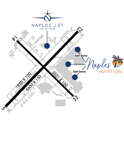
| Rwy | Rwy | |||||||
| 6600x150 | 5800' | 6600x150 | 5801' | |||||
| 5001x100 | 4873' | 5001x100 | 4550' | |||||
| 1850x100 | 1850' | 1850x100 | 1850' | |||||
| Runway ID | Single Wheel | Double Wheel | Double Tandem Wheel | Dual Double Wheel |
| 05/23 | N/A | 75,000 | N/A | N/A |
| 14/32 | N/A | 75,000 | N/A | N/A |
| NE/SW | N/A | N/A | N/A | N/A |
| These numbers are Advisory and are not limits. The Airport Manager should have more accurate Weight Limits | ||||
 Airport Diagram might not be current. | |
| Facility Name: | NAPLES MUNI |
| City Name: | NAPLES |
| County: | COLLIER |
| State abbrev: | FL |
| State Name: | FLORIDA |
| Ownership: | PUBLICLY OWNED |
| Use: | OPEN TO THE PUBLIC |
| Owner's Name: | CITY OF NAPLES APT AUTH |
| Address: | 160 AVIATION DR NORTH |
| NAPLES, FL 34104 | |
| Owner's Phone: | 239-643-0733 |
| Manager's Name: | CHRISTOPHER A. ROZANSKY |
| Address: | 160 AVIATION DR NORTH |
| NAPLES, FL 34104 | |
| Phone: | 239-643-0733 |
| FAA Region: | SOUTHERN |
| FAA Field Office: | ORL |
| Date | Sunrise | Sunset |
|---|---|---|
| 04/25/24 Thursday | 6:54 | 19:56 |
| 04/26/24 Friday | 6:53 | 19:57 |
| 04/27/24 Saturday | 6:52 | 19:57 |
| 04/28/24 Sunday | 6:52 | 19:58 |
| 04/29/24 Monday | 6:51 | 19:58 |
| 04/30/24 Tuesday | 6:50 | 19:59 |
| 05/01/24 Wednesday | 6:49 | 19:59 |
| 05/02/24 Thursday | 6:49 | 20:00 |
| 05/03/24 Friday | 6:48 | 20:00 |
| 05/04/24 Saturday | 6:47 | 20:01 |
| 05/05/24 Sunday | 6:46 | 20:01 |
| 05/06/24 Monday | 6:46 | 20:02 |
| 05/07/24 Tuesday | 6:45 | 20:03 |
| 05/08/24 Wednesday | 6:44 | 20:03 |
| Airport Attendance Schedule | 7 Days A Week 0600-2200 |
| Airport Status | OPERATIONAL (This Status can change at any time - please check NOTAMS) |
| Airport Lighting Schedule | WHEN ATCT CLSD ACTVT REIL RWY 05, 14, 23 & 32; PAPI RWY 14 & 32; MIRL RWY 05/23 & 14/32 - CTAF. |
| Airport Storage Available | Tie Downs, Hanger |
| Extra Services Available | Crop Dusting, Air Ambulance, Charter, Aircraft Rental, Aircraft Sales |
| Wind Indicator | YES - (lighted) |
| Control Tower | YES |
| CTAF Frequency | 128.500 |
| Unicom Frequency | FOR FBO SVC CTC NAPLES AVN - 128.825. |
| Rotating Beacon Color | WG |
| Segmented Circle | YES |
| Landing Fee | NO |
| Airport Inspected | FEDERAL - performed by FAA AIRPORTS FIELD PERSONNEL |
| Inspection Date | 05/01/2023 |
| Type of Fuel Available | Grade 100LL, JET A (freeze point -40C), JET AUL94 |
| Airframe Repair Service | MAJOR |
| Power Plant Repair Service | MAJOR |
| Latitude | N2609.1 |
| Longitude | W08146.5 (ESTIMATED) |
| Arpt Elevation | 8ft (SURVEYED) |
| Magnetic Variation | 03W |
| 2 miles NE | of NAPLES |
| Traffic Pattern Altitude | |
| Sectional Chart | MIAMI |
| Operations (Reported) | Yearly | Avg. Daily |
|---|---|---|
| General Aviation Transient | 71465 | 196 |
| General Aviation Local | 20123 | 55 |
| Air Taxi | 24987 | 68 |
| Commerical | 0 | 0 |
| Commuter | 0 | 0 |
| Military | 247 | 1 |
| Aircraft based on Field | |
|---|---|
| General Aviation Singles | 213 |
| General Aviation Multi | 40 |
| Jet Aircraft | 76 |
| General Aviation Helicopters | 20 |
| Military Aircraft | 0 |
| Gliders | 1 |
| Ultralights | 1 |
| FSS on field | NO |
| FSS tie-in | MIAMI |
| FSS Phone | 1-800-WX-BRIEF |
| Who issues Notams | APF |
| Notam D service at airport | YES |
| ARTCC Name | MIAMI |
| Airport Certification | AIRPORT RECEIVING SCHEDULED AIR CARRIER SERVICE FROM CARRIERS CERTIFICATED BY THE CIVIL AERONAUTICS BOARD |
| Aircraft Rescue & Firefighting Index | AIRPORT HAS A CERTIFICATE UNDER CFR PART 139 |
| Airport of Entry | No |
| Custom Landing Rights | No; US CUSTOMS USER FEE ARPT. |
| Joint Civil/Military | No |
| Military Landing rights | YES |
| NATIONAL PLAN OF INTEGRATED AIRPORT SYSTEMS (NPIAS) |
| GRANT AGREEMENTS UNDER FAAP/ADAP/AIP |
| ASSURANCES PURSUANT TO TITLE VI, CIVIL RIGHTS ACT OF 1964 |
| AGREEMENT UNDER DLAND OR DCLA HAS EXPIRED. |
| EXTMY NOISE SENSITIVE AREA ALL QUADS; TBJTS USE CLOSE-IN NOISE ABATEMENT PROC. |
| RUNUPS NA 2200 - 0700; TWY A RUNUP PADS FOR RWY 5/23 PISTON ACFT ONLY; JET ACFT RUNUP AREA TWY C BTW TWY C3 & TWY D PPR - ATCT . |
| RWY 23 DSGND CALM WIND RWY FOR ARRS 2200-0600. RWY 5 DSGND CALM WIND RWY FOR DEPS 2200-0600. |
| FULL SVC FUEL NOT AVBL DLY 0130-1030Z. |
| CLSD TO ACFT EXCEEDING 75000 LBS MAX GWT DUAL GEAR INDCD ON ACFT OPRG CERT ISSUED BY MANUFACTURER. |
| TWY C FM C-1 TO ER RWY 32 NOT VISIBLE FM ATCT. |
| STAGE 1 & 2 JET ACFT OPS PROHIBITED. VOLUNTARY RSTRN EXIST FOR ACFT OPS 2200-0700. VOLUNTARY RESTRAINT FROM TGL OPS 2200-0700. |
| FOR CD IF UNA TO CTC ON FSS FREQ, CTC FT MYERS APCH AT 239-416-1026, WHEN APCH CLSD CTC MIAMI ARTCC AT 305-716-1731. |
Airport Communications & Frequencies:
| |||||||||||||||||||||||||||
| Runway: 05 | Runway: 23 | ||
| Mag heading: | 47° | Mag heading: | 227° |
| Rwy Slope: | .00% Up | Rwy Slope: | .00% Down |
| Approach: | Approach: | ||
| Pattern: | Right Traffic | Pattern: | Left Traffic |
| Markings: | NONPRECISION INSTRUMENT | Markings: | NONPRECISION INSTRUMENT |
| Marking Condition: | GOOD | Marking Condition: | GOOD |
| Arresting Dev: | Arresting Dev: | ||
| Lat & Long: | N2608.8 W08146.9 | Lat. & Long.: | N2609.6 W08146.1 |
| Elev: | 6.1 ft. MSL | Elev: | 6.2 ft. MSL |
| TCH: | 31 ft. AGL | TCH: | 42 ft. AGL |
| Visual Glide Path: | 3.50 degrees | Visual Glide Path: | 3.00 degrees |
| Displaced Threshold: | 800 feet | Displaced Threshold: | 799 feet |
| Touchdown Zone: | YES | Touchdown Zone: | YES |
| Touchdown Elev.: | 7.7 feet | Touchdown Elev.: | 8.3 feet |
| Visual Glide Slope: | 4-Light PAPI on RIGHT side of Runway | Visual Glide Slope: | 4-Light PAPI on LEFT side of Runway |
| RVR Equipment: | RVR Equipment: | ||
| RVV Equipment: | NO | RVV Equipment: | NO |
| Approach Lights: | Approach Lights: | ||
| REIL: | YES | REIL: | YES |
| Centerline Lights: | NO | Centerline Lights: | NO |
| Touchdown lights: | NO | Touchdown lights: | NO |
| Runway Category: | Runway with a Non-precision Approach having visibility minimums greater than 3/4 mile | Runway Category: | Runway with a Non-precision Approach having visibility minimums greater than 3/4 mile |
| Declared Distances: | TORA:5800' TODA:5800' ASDA:5800' LDA:5000' | Declared Distances: | TORA:5800' TODA:5800' ASDA:5800' LDA:5000' |
| Obstructions: | ROAD | Obstructions: | FENCE |
| Marked: | LIGHTED | Marked: | LIGHTED |
| Clearance slope: | 12:1; RWY 05 APCH SLOPE 50:1 TO DSPLCD THR. | Clearance slope: | 2:1; RWY 23 APCH SLOPE 47:1 TO DSPLCD THR. |
| Obstruction height: | 15 feet AGL | Obstruction height: | 8 feet AGL |
| Dist. from runway: | 385 feet | Dist. from runway: | 215 feet |
| Centerline offset: | 250 right of centerline | Centerline offset: | 250 feet right of centerline |
| Comments: | Comments: |
| Runway: 14 | Runway: 32 | ||
| Mag heading: | 137° | Mag heading: | 317° |
| Rwy Slope: | .01% Up | Rwy Slope: | -.01% Down |
| Approach: | Approach: | ||
| Pattern: | Right Traffic | Pattern: | Left Traffic |
| Markings: | BASIC | Markings: | BASIC |
| Marking Condition: | FAIR | Marking Condition: | FAIR |
| Arresting Dev: | Arresting Dev: | ||
| Lat & Long: | N2609.5 W08146.8 | Lat. & Long.: | N2608.9 W08146.2 |
| Elev: | 6.2 ft. MSL | Elev: | 6.9 ft. MSL |
| TCH: | 41 ft. AGL | TCH: | 40 ft. AGL |
| Visual Glide Path: | 3.50 degrees | Visual Glide Path: | 3.00 degrees |
| Displaced Threshold: | 128 feet | Displaced Threshold: | 451 feet |
| Touchdown Zone: | YES | Touchdown Zone: | YES |
| Touchdown Elev.: | 7.6 feet | Touchdown Elev.: | 7.6 feet |
| Visual Glide Slope: | 4-Light PAPI on LEFT side of Runway | Visual Glide Slope: | 4-Light PAPI on LEFT side of Runway |
| RVR Equipment: | RVR Equipment: | ||
| RVV Equipment: | NO | RVV Equipment: | NO |
| Approach Lights: | Approach Lights: | ||
| REIL: | YES | REIL: | YES |
| Centerline Lights: | NO | Centerline Lights: | NO |
| Touchdown lights: | NO | Touchdown lights: | NO |
| Runway Category: | Runway with a Visual Approach | Runway Category: | Runway with a Visual Approach |
| Declared Distances: | TORA:5001' TODA:5001' ASDA:4550' LDA:4420' | Declared Distances: | TORA:5001' TODA:5001' ASDA:4870' LDA:4420' |
| Obstructions: | TREES | Obstructions: | TREES |
| Marked: | NOT Marked/Lighted | Marked: | NOT Marked/Lighted |
| Clearance slope: | 20:1 | Clearance slope: | 24:1 |
| Obstruction height: | 47 feet AGL | Obstruction height: | 44 feet AGL |
| Dist. from runway: | 1155 feet | Dist. from runway: | 1275 feet |
| Centerline offset: | 240 left of centerline | Centerline offset: | 165 feet right of centerline |
| Comments: | Comments: |
| Runway: NE | Runway: SW | ||
| Mag heading: | 227° | Mag heading: | 47° |
| Rwy Slope: | .02% Up | Rwy Slope: | -.02% Down |
| Approach: | Approach: | ||
| Pattern: | Left Traffic | Pattern: | Left Traffic |
| Markings: | NONSTANDARD | Markings: | NONSTANDARD |
| Marking Condition: | GOOD; RWY NE/SW MKD WITH PAVERS & PVC PIPES. | Marking Condition: | GOOD; RWY NE/SW MKD WITH PAVERS & PVC PIPES. |
| Arresting Dev: | Arresting Dev: | ||
| Lat & Long: | N2608.9 W08146.8 | Lat. & Long.: | N2609.1 W08146.6 |
| Elev: | 4.6 ft. MSL | Elev: | 4.9 ft. MSL |
| TCH: | TCH: | ||
| Visual Glide Path: | Visual Glide Path: | ||
| Displaced Threshold: | No | Displaced Threshold: | No |
| Touchdown Zone: | YES | Touchdown Zone: | YES |
| Touchdown Elev.: | 4.9 feet | Touchdown Elev.: | 4.9 feet |
| Visual Glide Slope: | Visual Glide Slope: | ||
| RVR Equipment: | RVR Equipment: | ||
| RVV Equipment: | NO | RVV Equipment: | NO |
| Approach Lights: | Approach Lights: | ||
| REIL: | NO | REIL: | NO |
| Centerline Lights: | NO | Centerline Lights: | NO |
| Touchdown lights: | NO | Touchdown lights: | NO |
| Runway Category: | Runway with a Visual Approach | Runway Category: | Runway with a Visual Approach |
| Declared Distances: | Declared Distances: |
Thanks for using FltPlan.com
all rights reserved © 1999-2024 by Flight Plan LLC