
| RICK HUSBAND AMARILLO INTL AMARILLO TX |
| |
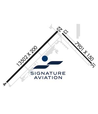
| Lat: N 3513.2 Long: W 10142.4 Elev: 3607 Var: -08 Longest Runway: 13502 | ||
| Clr Del: 121.65 Dept. ATIS: 118.85 Arr. ATIS: 118.85 AWOS: 118.85 Ground: 121.9 Tower: 118.3 | ||
| |||||||||||||||||||||||||||||||||||||||||||||||||||||||||||||||||||||
| |||||||||||||||||||||||||||||||||||||||||||||||||||||||||||||||||||||
| |||||||||||||||||||||||||||||||||||||||||||||||||||||||||||||||||||||
| Rwy | Rwy | |||||||
| 13502x200 | 13502' | 110.30 - 037° | 13502x200 | 13502' | 111.10 - 213° | |||
| 7901x150 | 7901' | 7901x150 | 7901' | |||||
| Runway ID | Single Wheel | Double Wheel | Double Tandem Wheel | Dual Double Wheel |
| 04/22 | 100,000 | 200,000 | 400,000 | N/A |
| 13/31 | 100,000 | 200,000 | 400,000 | N/A |
| These numbers are Advisory and are not limits. The Airport Manager should have more accurate Weight Limits | ||||
 Airport Diagram might not be current. | |
| Facility Name: | RICK HUSBAND AMARILLO INTL |
| City Name: | AMARILLO |
| County: | POTTER |
| State abbrev: | TX |
| State Name: | TEXAS |
| Ownership: | PUBLICLY OWNED |
| Use: | OPEN TO THE PUBLIC |
| Owner's Name: | CITY OF AMARILLO |
| Address: | PO BOX 1971 |
| AMARILLO, TX 79105 | |
| Owner's Phone: | 806-378-3000 |
| Manager's Name: | MICHAEL CONNER |
| Address: | 10801 ARPT BLVD |
| AMARILLO, TX 79111 | |
| Phone: | 806-335-1671 |
| FAA Region: | SOUTHWEST |
| FAA Field Office: | TEX |
| Date | Sunrise | Sunset |
|---|---|---|
| 09/24/21 Friday | 7:36 | 19:41 |
| 09/25/21 Saturday | 7:37 | 19:40 |
| 09/26/21 Sunday | 7:38 | 19:38 |
| 09/27/21 Monday | 7:38 | 19:37 |
| 09/28/21 Tuesday | 7:39 | 19:35 |
| 09/29/21 Wednesday | 7:40 | 19:34 |
| 09/30/21 Thursday | 7:41 | 19:32 |
| 10/01/21 Friday | 7:41 | 19:31 |
| 10/02/21 Saturday | 7:42 | 19:30 |
| 10/03/21 Sunday | 7:43 | 19:28 |
| 10/04/21 Monday | 7:44 | 19:27 |
| 10/05/21 Tuesday | 7:45 | 19:25 |
| 10/06/21 Wednesday | 7:45 | 19:24 |
| 10/07/21 Thursday | 7:46 | 19:23 |
| Airport Attendance Schedule | CONTINUOUS |
| Airport Status | OPERATIONAL (This Status can change at any time - please check NOTAMS) |
| Airport Lighting Schedule | WHEN ATCT CLSD, TO INCR INTST AND ACTVT MALSR RWYS 04 & 22; REIL RWYS 13 & 31; HIRL RWYS 04/22, 13/31; ALL TWYS - CTAF. |
| Airport Storage Available | Tie Downs, Hanger |
| Extra Services Available | Air Freight, Air Ambulance, Avionics, Cargo Handling, Charter, Flight Instruction, Aircraft Rental, Aircraft Sales |
| Wind Indicator | YES - (lighted) |
| Control Tower | YES |
| CTAF Frequency | 118.300 |
| Unicom Frequency | 122.950 |
| Rotating Beacon Color | CLEAR-GREEN (Light Land Airport) |
| Segmented Circle | YES |
| Landing Fee | NO |
| Airport Inspected | FEDERAL - performed by FAA AIRPORTS FIELD PERSONNEL |
| Inspection Date | 09/15/2020 |
| Type of Fuel Available | Grade 100LL, JET A-1 (icing inhibitor, freeze point -50C) |
| Airframe Repair Service | MAJOR |
| Power Plant Repair Service | MAJOR |
| Latitude | N3513.2 |
| Longitude | W10142.4 (ESTIMATED) |
| Arpt Elevation | 3606ft (SURVEYED) |
| Magnetic Variation | 08E |
| 7 miles E | of AMARILLO |
| Traffic Pattern Altitude | 895; TPA: 895 FT AGL PROP ACFT, 1395 FT AGL TURBOJET ACFT, 1895 FT AGL OVERHEAD . |
| Sectional Chart | DALLAS-FT WORTH |
| Operations (Reported) | Yearly | Avg. Daily |
|---|---|---|
| General Aviation Transient | 12583 | 34 |
| General Aviation Local | 7016 | 19 |
| Air Taxi | 5837 | 16 |
| Commerical | 7099 | 19 |
| Commuter | 0 | 0 |
| Military | 15835 | 43 |
| Aircraft based on Field | |
|---|---|
| General Aviation Singles | 18 |
| General Aviation Multi | 11 |
| Jet Aircraft | 6 |
| General Aviation Helicopters | 0 |
| Military Aircraft | 0 |
| Gliders | 0 |
| Ultralights | 0 |
| FSS on field | NO |
| FSS tie-in | FORT WORTH |
| FSS Phone | 1-800-WX-BRIEF |
| Who issues Notams | AMA |
| Notam D service at airport | YES |
| ARTCC Name | ALBUQUERQUE |
| Airport Certification | AIRPORT RECEIVING SCHEDULED AIR CARRIER SERVICE FROM CARRIERS CERTIFICATED BY THE CIVIL AERONAUTICS BOARD; INDEX C EQUIP AVBL UPON REQ. |
| Aircraft Rescue & Firefighting Index | AIRPORT HAS A CERTIFICATE UNDER CFR PART 139 |
| Airport of Entry | No |
| Custom Landing Rights | YES |
| Joint Civil/Military | No |
| Military Landing rights | YES |
| NATIONAL PLAN OF INTEGRATED AIRPORT SYSTEMS (NPIAS) |
| GRANT AGREEMENTS UNDER FAAP/ADAP/AIP |
| SURPLUS PROPERTY AGREEMENT UNDER PUBLIC LAW 289 |
| ASSURANCES PURSUANT TO TITLE VI, CIVIL RIGHTS ACT OF 1964 |
| AGREEMENT UNDER DLAND OR DCLA HAS EXPIRED. |
| TILTROTOR ACFT ACTIVITY INVOF ARPT. |
| LDG FEE. |
| FOR CD IF UNA TO CTC ON FSS FREQ, CTC ALBUQUERQUE ARTCC AT 505-856-4561. |
| RWY 04/2 2 CENTER 130 FT GROOVED FULL LENGTH. |
| RWY 04/2 2 RWY 04/22 NSTD HIRL DUE TO SPACING. HIRL 50 FT FM RWY EDGE, NSTD DSTC FM CNTRLN - PAVEMENT OUTSIDE RWY EDGE STRIPES MAY NOT BE FULL STRENGTH AND DEPTH PERCEPTION PROBLEMS MAY EXIST DURING PERIODS OF DARKNESS. |
Airport Communications & Frequencies:
| |||||||||||||||||||||||||||||||||||||||||||||||||
| Runway: 04 | Runway: 22 | ||
| Mag heading: | 38° | Mag heading: | 218° |
| Rwy Slope: | -.03% Down | Rwy Slope: | .03% Up |
| Approach: | ILS | Approach: | LDA/DME |
| Pattern: | Left Traffic | Pattern: | Left Traffic |
| Markings: | PRECISION INSTRUMENT | Markings: | PRECISION INSTRUMENT |
| Marking Condition: | GOOD | Marking Condition: | GOOD |
| Arresting Dev: | Arresting Dev: | ||
| Lat & Long: | N3512.3 W10144.0 | Lat. & Long.: | N3513.9 W10142.0 |
| Elev: | 3606.4 ft. MSL | Elev: | 3602.7 ft. MSL |
| TCH: | 61 ft. AGL | TCH: | 77 ft. AGL |
| Visual Glide Path: | 3.00 degrees | Visual Glide Path: | 3.00 degrees |
| Displaced Threshold: | No | Displaced Threshold: | No |
| Touchdown Zone: | YES | Touchdown Zone: | YES |
| Touchdown Elev.: | 3606.5 feet | Touchdown Elev.: | 3605.6 feet |
| Visual Glide Slope: | 4-Light PAPI on LEFT side of Runway | Visual Glide Slope: | 4-Light PAPI on LEFT side of Runway |
| RVR Equipment: | TOUCHDOWN; RVR AVBL 1200-0600Z CTC ATCT. | RVR Equipment: | ROLLOUT |
| RVV Equipment: | NO | RVV Equipment: | NO |
| Approach Lights: | MALSR - 1,400 foot medium intensity approach lighting system with runway alignment indicator lights | Approach Lights: | MALSR - 1,400 foot medium intensity approach lighting system with runway alignment indicator lights |
| REIL: | NO | REIL: | NO |
| Centerline Lights: | NO | Centerline Lights: | NO |
| Touchdown lights: | NO | Touchdown lights: | NO |
| Runway Category: | Precision Instrument Runway | Runway Category: | Precision Instrument Runway |
| Declared Distances: | TORA:13502' TODA:13502' ASDA:13502' LDA:13502' | Declared Distances: | TORA:13502' TODA:13502' ASDA:13502' LDA:13502' |
| Runway: 13 | Runway: 31 | ||
| Mag heading: | 129° | Mag heading: | 309° |
| Rwy Slope: | -.11% Down | Rwy Slope: | .11% Up |
| Approach: | Approach: | ||
| Pattern: | Left Traffic | Pattern: | Left Traffic |
| Markings: | NONPRECISION INSTRUMENT | Markings: | NONPRECISION INSTRUMENT |
| Marking Condition: | GOOD | Marking Condition: | GOOD |
| Arresting Dev: | Arresting Dev: | ||
| Lat & Long: | N3513.8 W10141.8 | Lat. & Long.: | N3512.8 W10140.7 |
| Elev: | 3603.2 ft. MSL | Elev: | 3594.4 ft. MSL |
| TCH: | 52 ft. AGL | TCH: | 52 ft. AGL |
| Visual Glide Path: | 3.00 degrees | Visual Glide Path: | 3.00 degrees |
| Displaced Threshold: | No | Displaced Threshold: | No |
| Touchdown Zone: | YES | Touchdown Zone: | YES |
| Touchdown Elev.: | 3603.3 feet | Touchdown Elev.: | 3601.0 feet |
| Visual Glide Slope: | 4-Light PAPI on LEFT side of Runway | Visual Glide Slope: | 4-Light PAPI on LEFT side of Runway |
| RVR Equipment: | RVR Equipment: | ||
| RVV Equipment: | NO | RVV Equipment: | NO |
| Approach Lights: | Approach Lights: | ||
| REIL: | YES | REIL: | YES |
| Centerline Lights: | NO | Centerline Lights: | NO |
| Touchdown lights: | NO | Touchdown lights: | NO |
| Runway Category: | D | Runway Category: | D |
| Declared Distances: | TORA:7901' TODA:7901' ASDA:7901' LDA:7901' | Declared Distances: | TORA:7901' TODA:7901' ASDA:7901' LDA:7901' |
Thanks for using FltPlan.com
all rights reserved © 1999-2021 by Flight Plan LLC