| COLONEL JAMES JABARA WICHITA KS |
| |
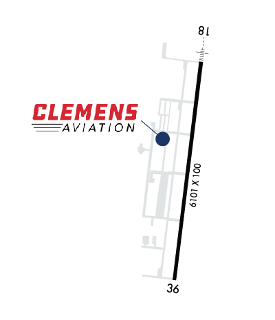
| Lat: N 3744.9 Long: W 09713.3 Elev: 1421 Var: -06 Longest Runway: 6101 | ||
| Clr Del: 125.0 AWOS: 134.02 CTAF: 122.7 | ||
| ||||||||||||||||||||||||||||||
| ||||||||||||||||||||||||||||||
| ||||||||||||||||||||||||||||||
| Rwy | Rwy | |||||||
| 6101x100 | 6101' | 109.55 - 181° | 6101x100 | 6101' | ||||
| Runway ID | Single Wheel | Double Wheel | Double Tandem Wheel | Dual Double Wheel |
| 18/36 | 40,000 | 62,000 | N/A | N/A |
| These numbers are Advisory and are not limits. The Airport Manager should have more accurate Weight Limits | ||||
 Airport Diagram might not be current. | |
| Facility Name: | COLONEL JAMES JABARA |
| City Name: | WICHITA |
| County: | SEDGWICK |
| State abbrev: | KS |
| State Name: | KANSAS |
| Ownership: | PUBLICLY OWNED |
| Use: | OPEN TO THE PUBLIC |
| Owner's Name: | WICHITA AIRPORT AUTHORITY |
| Address: | 2173 AIR CARGO RD |
| WICHITA, KS 67209 | |
| Owner's Phone: | 316-946-4700 |
| Manager's Name: | VICTOR WHITE |
| Address: | WICHITA AIRPORT AUTHORITY, 2173 AIR CARGO RD |
| WICHITA, KS 67209 | |
| Phone: | 316-946-4700 |
| FAA Region: | CENTRAL |
| FAA Field Office: | NONE |

| Date | Sunrise | Sunset |
|---|---|---|
| 09/24/21 Friday | 7:18 | 19:23 |
| 09/25/21 Saturday | 7:19 | 19:21 |
| 09/26/21 Sunday | 7:20 | 19:20 |
| 09/27/21 Monday | 7:21 | 19:18 |
| 09/28/21 Tuesday | 7:22 | 19:17 |
| 09/29/21 Wednesday | 7:23 | 19:15 |
| 09/30/21 Thursday | 7:23 | 19:14 |
| 10/01/21 Friday | 7:24 | 19:12 |
| 10/02/21 Saturday | 7:25 | 19:11 |
| 10/03/21 Sunday | 7:26 | 19:09 |
| 10/04/21 Monday | 7:27 | 19:08 |
| 10/05/21 Tuesday | 7:28 | 19:06 |
| 10/06/21 Wednesday | 7:29 | 19:05 |
| 10/07/21 Thursday | 7:30 | 19:03 |
| Airport Attendance Schedule | CONTINUOUS |
| Airport Status | OPERATIONAL (This Status can change at any time - please check NOTAMS) |
| Airport Lighting Schedule | APT LGT SKED: ACTVT MIRL RY 18/36, MALSR RY 18, REIL RY 36 - CTAF. PAPI RYS 18 & 36 OPR CONT. |
| Airport Storage Available | Tie Downs, Hanger |
| Extra Services Available | Air Ambulance, Charter, Flight Instruction, Aircraft Sales |
| Wind Indicator | YES - (lighted) |
| Control Tower | NO |
| CTAF Frequency | 122.700 |
| Unicom Frequency | 122.700 |
| Rotating Beacon Color | CLEAR-GREEN (Light Land Airport) |
| Segmented Circle | YES |
| Landing Fee | NO |
| Airport Inspected | STATE - performed by STATE AERONAUTICAL PERSONNEL |
| Inspection Date | 08/13/2019 |
| Type of Fuel Available | Grade 100LL, JET A (freeze point -40C); -10FOR 24 HOUR FUEL CONTACT FBO |
| Airframe Repair Service | MAJOR |
| Power Plant Repair Service | MAJOR |
| Latitude | N3744.9 |
| Longitude | W09713.3 (ESTIMATED) |
| Arpt Elevation | 1420ft (SURVEYED) |
| Magnetic Variation | 06E |
| 9 miles NE | of WICHITA |
| Traffic Pattern Altitude | |
| Sectional Chart | WICHITA |
| Operations (Reported) | Yearly | Avg. Daily |
|---|---|---|
| General Aviation Transient | 19000 | 52 |
| General Aviation Local | 18000 | 49 |
| Air Taxi | 1300 | 4 |
| Commerical | 0 | 0 |
| Commuter | 0 | 0 |
| Military | 0 | 0 |
| Aircraft based on Field | |
|---|---|
| General Aviation Singles | 60 |
| General Aviation Multi | 31 |
| Jet Aircraft | 20 |
| General Aviation Helicopters | 1 |
| Military Aircraft | 1 |
| Gliders | 0 |
| Ultralights | 0 |
| FSS on field | NO |
| FSS tie-in | WICHITA |
| FSS Phone | 1-800-WX-BRIEF |
| Who issues Notams | AAO |
| Notam D service at airport | YES |
| ARTCC Name | KANSAS CITY |
| Airport Certification | |
| Aircraft Rescue & Firefighting Index | None |
| Airport of Entry | No |
| Custom Landing Rights | No |
| Joint Civil/Military | No |
| Military Landing rights | YES |
| NATIONAL PLAN OF INTEGRATED AIRPORT SYSTEMS (NPIAS) |
| GRANT AGREEMENTS UNDER FAAP/ADAP/AIP |
| ASSURANCES PURSUANT TO TITLE VI, CIVIL RIGHTS ACT OF 1964 |
| THIS AIRPORT HAS BEEN SURVEYED BY THE NATIONAL GEODETIC SURVEY. |
| ATNDD CONSY. |
| USE CTN FOR MCCONNELL AFB 9 MILES S AND BEECH FACTORY ARPT 3 MILES S. |
| BEECH FACTORY ARPT CLASS D ASP BEGINS 1 MILE S OF RWY 18 DER. |
| SOUTHERLY AND SOUTHEASTERLY VFR ARR AND DEP NOT RCMDD WO ATC RADAR SVCS DUE TO BEECH FACTORY ARPT AND MCCONNELL CLASS D AFB ASP. |
| VFR ARR AND DEP ARE RCMDD TO RMN AOB 2500 FT MSL WITHIN 5 MILES DUE TO HEAVY MIL TFC AOA 3000 FT MSL. |
| MIGRATORY BIRDS INVOF ARPT. |
| DUE TO 20 FT RWY END ELEV DIFFERENTIAL, PILOTS MAY LOSE LINE OF SIGHT OF OTHER ACFT ON OPPOSING RWY ENDS. |
| NOISE SENSITIVE AREAS S, SW, AND W. |
| PPR FOR ACFT CARRYING CLASS 1 - DIVISION 1.1, 1.2, OR 1.3 XPLOSS AS DEFINED BY 49 CFR 173.50 OR AS AMDD. |
| RWY 18 NSTD TFC PAT. |
| FOR CD CTC WICHITA APCH AT 316-350-1520. |
| ALL TFC PATS W OF FIELD. |
| RWY 36 DSGND CALM WIND RWY. |
Airport Communications & Frequencies:
| ||||||||||||||||
| Runway: 18 | Runway: 36 | ||
| Mag heading: | 181° | Mag heading: | 1° |
| Rwy Slope: | .32% Up | Rwy Slope: | -.32% Down |
| Approach: | ILS/DME | Approach: | |
| Pattern: | Right Traffic | Pattern: | Left Traffic |
| Markings: | PRECISION INSTRUMENT | Markings: | NONPRECISION INSTRUMENT |
| Marking Condition: | GOOD | Marking Condition: | GOOD |
| Arresting Dev: | Arresting Dev: | ||
| Lat & Long: | N3745.4 W09713.2 | Lat. & Long.: | N3744.4 W09713.3 |
| Elev: | 1401.2 ft. MSL | Elev: | 1420.8 ft. MSL |
| TCH: | 45 ft. AGL | TCH: | 45 ft. AGL |
| Visual Glide Path: | 3.00 degrees | Visual Glide Path: | 3.00 degrees |
| Displaced Threshold: | No | Displaced Threshold: | No |
| Touchdown Zone: | YES | Touchdown Zone: | YES |
| Touchdown Elev.: | 1413.8 feet | Touchdown Elev.: | 1420.8 feet |
| Visual Glide Slope: | 4-Light PAPI on LEFT side of Runway | Visual Glide Slope: | 4-Light PAPI on LEFT side of Runway |
| RVR Equipment: | RVR Equipment: | ||
| RVV Equipment: | NO | RVV Equipment: | NO |
| Approach Lights: | MALSR - 1,400 foot medium intensity approach lighting system with runway alignment indicator lights | Approach Lights: | |
| REIL: | NO | REIL: | YES |
| Centerline Lights: | NO | Centerline Lights: | NO |
| Touchdown lights: | NO | Touchdown lights: | NO |
| Runway Category: | Precision Instrument Runway | Runway Category: | Runway with a Non-precision Approach having visibility minimums greater than 3/4 mile |
| Declared Distances: | Declared Distances: |
Thanks for using FltPlan.com
all rights reserved © 1999-2021 by Flight Plan LLC