
| MACON-FOWER MEMORIAL MACON MO |
| |
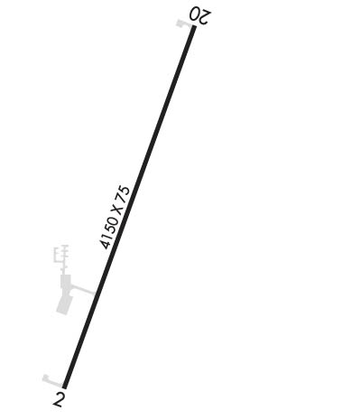
| Lat: N 3943.8 Long: W 09227.4 Elev: 878 Var: -02 Longest Runway: 4150 | ||
| CTAF: 122.8 | ||
| ||||||||||||||||||||||||||||||||||||||||||||
| ||||||||||||||||||||||||||||||||||||||||||||
| Rwy | Rwy | |||||||
| 4150x75 | 3554' | 4150x75 | 4150' | |||||
| Runway ID | Single Wheel | Double Wheel | Double Tandem Wheel | Dual Double Wheel |
| 02/20 | 12,500 | N/A | N/A | N/A |
| These numbers are Advisory and are not limits. The Airport Manager should have more accurate Weight Limits | ||||
 Airport Diagram might not be current. | |
| Facility Name: | MACON-FOWER MEML |
| City Name: | MACON |
| County: | MACON |
| State abbrev: | MO |
| State Name: | MISSOURI |
| Ownership: | PUBLICLY OWNED |
| Use: | OPEN TO THE PUBLIC |
| Owner's Name: | CITY OF MACON |
| Address: | 106 W. BOURKE, PO BOX 569 |
| MACON, MO 63552 | |
| Owner's Phone: | 660-385-6421 |
| Manager's Name: | GREG YOUNG |
| Address: | 1001 PATTON ST |
| MACON, MO 63552 | |
| Phone: | 660-385-6208 |
| FAA Region: | CENTRAL |
| FAA Field Office: | NONE |
| Date | Sunrise | Sunset |
|---|---|---|
| 09/24/21 Friday | 6:59 | 19:04 |
| 09/25/21 Saturday | 7:00 | 19:02 |
| 09/26/21 Sunday | 7:01 | 19:01 |
| 09/27/21 Monday | 7:02 | 18:59 |
| 09/28/21 Tuesday | 7:03 | 18:57 |
| 09/29/21 Wednesday | 7:04 | 18:56 |
| 09/30/21 Thursday | 7:05 | 18:54 |
| 10/01/21 Friday | 7:06 | 18:53 |
| 10/02/21 Saturday | 7:07 | 18:51 |
| 10/03/21 Sunday | 7:08 | 18:49 |
| 10/04/21 Monday | 7:09 | 18:48 |
| 10/05/21 Tuesday | 7:10 | 18:46 |
| 10/06/21 Wednesday | 7:11 | 18:45 |
| 10/07/21 Thursday | 7:12 | 18:43 |
| Airport Attendance Schedule | 7 Days A Week 0800-1700 |
| Airport Status | OPERATIONAL (This Status can change at any time - please check NOTAMS) |
| Airport Lighting Schedule | ACTVT REIL RWY 02 & 20; PAPI RWY 02 & 20; MIRL RWY 02/20 - CTAF. |
| Airport Storage Available | Tie Downs, Hanger |
| Extra Services Available | Flight Instruction |
| Wind Indicator | YES - (lighted) |
| Control Tower | NO |
| CTAF Frequency | 122.800 |
| Unicom Frequency | 122.800 |
| Rotating Beacon Color | CLEAR-GREEN (Light Land Airport) |
| Segmented Circle | YES |
| Landing Fee | NO |
| Airport Inspected | STATE - performed by STATE AERONAUTICAL PERSONNEL |
| Inspection Date | 06/25/2019 |
| Type of Fuel Available | Grade 100LL, JET A; -10SELF SVC 100LL AND JET-A FUEL AVBL 24 HRS. |
| Airframe Repair Service | MAJOR |
| Power Plant Repair Service | MAJOR |
| Latitude | N3943.8 |
| Longitude | W09227.4 (ESTIMATED) |
| Arpt Elevation | 878ft (SURVEYED) |
| Magnetic Variation | 02E |
| 1 miles SE | of MACON |
| Traffic Pattern Altitude | |
| Sectional Chart | KANSAS CITY |
| Operations (Reported) | Yearly | Avg. Daily |
|---|---|---|
| General Aviation Transient | 1890 | 5 |
| General Aviation Local | 1289 | 4 |
| Air Taxi | 210 | 1 |
| Commerical | 0 | 0 |
| Commuter | 0 | 0 |
| Military | 20 | 0 |
| Aircraft based on Field | |
|---|---|
| General Aviation Singles | 19 |
| General Aviation Multi | 0 |
| Jet Aircraft | 0 |
| General Aviation Helicopters | 0 |
| Military Aircraft | 0 |
| Gliders | 0 |
| Ultralights | 0; ULTRALIGHT ACFT ON & INVOF ARPT. |
| FSS on field | NO |
| FSS tie-in | COLUMBIA |
| FSS Phone | 1-800-WX-BRIEF |
| Who issues Notams | COU |
| Notam D service at airport | YES |
| ARTCC Name | KANSAS CITY |
| Airport Certification | |
| Aircraft Rescue & Firefighting Index | None |
| Airport of Entry | No |
| Custom Landing Rights | No |
| Joint Civil/Military | No |
| Military Landing rights | YES |
| NATIONAL PLAN OF INTEGRATED AIRPORT SYSTEMS (NPIAS) |
| GRANT AGREEMENTS UNDER FAAP/ADAP/AIP |
| ASSURANCES PURSUANT TO TITLE VI, CIVIL RIGHTS ACT OF 1964 |
| CROP DUSTING ACFT ON & INVOF ARPT APR-OCT. |
| DEER ON RWY AT EARLY & LATE HRS. |
| FOR SVC AFT HRS CALL 660-385-6208. |
| FOR CD CTC KANSAS CITY ARTCC AT 913-254-8508. |
Airport Communications & Frequencies:
| |||||||||
| Runway: 02 | Runway: 20 | ||
| Mag heading: | 18° | Mag heading: | 198° |
| Rwy Slope: | -.65% Down | Rwy Slope: | .65% Up |
| Approach: | Approach: | ||
| Pattern: | Right Traffic | Pattern: | Left Traffic |
| Markings: | NONPRECISION INSTRUMENT | Markings: | NONPRECISION INSTRUMENT |
| Marking Condition: | GOOD | Marking Condition: | GOOD |
| Arresting Dev: | Arresting Dev: | ||
| Lat & Long: | N3943.5 W09227.6 | Lat. & Long.: | N3944.1 W09227.3 |
| Elev: | 877.7 ft. MSL | Elev: | 850.7 ft. MSL |
| TCH: | 31 ft. AGL | TCH: | 41 ft. AGL |
| Visual Glide Path: | 3.00 degrees | Visual Glide Path: | 3.00 degrees |
| Displaced Threshold: | 596 feet | Displaced Threshold: | No |
| Touchdown Zone: | YES | Touchdown Zone: | YES |
| Touchdown Elev.: | 876.3 feet | Touchdown Elev.: | 873.6 feet |
| Visual Glide Slope: | 4-Light PAPI on LEFT side of Runway | Visual Glide Slope: | 4-Light PAPI on LEFT side of Runway; UNUSBL BYD 5 DEGS LEFT OF CNTRLN. |
| RVR Equipment: | RVR Equipment: | ||
| RVV Equipment: | NO | RVV Equipment: | NO |
| Approach Lights: | Approach Lights: | ||
| REIL: | YES | REIL: | YES |
| Centerline Lights: | NO | Centerline Lights: | NO |
| Touchdown lights: | NO | Touchdown lights: | NO |
| Runway Category: | Runway with a Non-precision Approach | Runway Category: | Runway with a Non-precision Approach |
| Declared Distances: | Declared Distances: |
Thanks for using FltPlan.com
all rights reserved © 1999-2021 by Flight Plan LLC
