
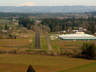
| STARK'S TWIN OAKS AIRPARK HILLSBORO OR |
| |
| Lat: N 4525.7 Long: W 12256.5 Elev: 170 Var: -19 Longest Runway: 2465 | ||
| Clr Del: 119.95 CTAF: 123.05 | ||
| |||||||||||||||||||||||||||||||||||||||||||||||||||||||||||||
| |||||||||||||||||||||||||||||||||||||||||||||||||||||||||||||
| Rwy | Rwy | |||||||
| 2465x48 | 2365' | 2465x48 | 2465' | |||||
| Runway ID | Single Wheel | Double Wheel | Double Tandem Wheel | Dual Double Wheel |
| 02/20 | N/A | N/A | N/A | N/A |
| These numbers are Advisory and are not limits. The Airport Manager should have more accurate Weight Limits | ||||
| FltPlan does not have IFR approach charts available for K7S3. |
| Facility Name: | STARK'S TWIN OAKS AIRPARK |
| City Name: | HILLSBORO |
| County: | WASHINGTON |
| State abbrev: | OR |
| State Name: | OREGON |
| Ownership: | PRIVATELY OWNED |
| Use: | OPEN TO THE PUBLIC |
| Owner's Name: | ROBERT C & BETTY STARK |
| Address: | 12405 S.W. RIVER RD |
| HILLSBORO, OR 97123 | |
| Owner's Phone: | 503-522-8952 |
| Manager's Name: | ROBERT C. STARK; BOB@TWINOAKSAIRPARK.COM |
| Address: | 12405 S.W. RIVER RD |
| HILLSBORO, OR 97123 | |
| Phone: | 503-628-2817 |
| FAA Region: | NORTHWEST MOUNTAIN |
| FAA Field Office: | SEA |
| Date | Sunrise | Sunset |
|---|---|---|
| 09/24/21 Friday | 7:01 | 19:06 |
| 09/25/21 Saturday | 7:02 | 19:04 |
| 09/26/21 Sunday | 7:04 | 19:02 |
| 09/27/21 Monday | 7:05 | 19:00 |
| 09/28/21 Tuesday | 7:06 | 18:58 |
| 09/29/21 Wednesday | 7:07 | 18:56 |
| 09/30/21 Thursday | 7:08 | 18:54 |
| 10/01/21 Friday | 7:10 | 18:52 |
| 10/02/21 Saturday | 7:11 | 18:50 |
| 10/03/21 Sunday | 7:12 | 18:49 |
| 10/04/21 Monday | 7:14 | 18:47 |
| 10/05/21 Tuesday | 7:15 | 18:45 |
| 10/06/21 Wednesday | 7:16 | 18:43 |
| 10/07/21 Thursday | 7:17 | 18:41 |
| Airport Attendance Schedule | 7 Days A Week DAWN-DUSK |
| Airport Status | OPERATIONAL (This Status can change at any time - please check NOTAMS) |
| Airport Lighting Schedule | ACTIVATE LIRL RY 02/20-CTAF; AFT 0000 PPR CALL AMGR 503-628-2817. |
| Airport Storage Available | Tie Downs |
| Extra Services Available | Flight Instruction, Aircraft Rental, Aircraft Sales |
| Wind Indicator | YES - (unlit) |
| Control Tower | NO |
| CTAF Frequency | 123.050 |
| Unicom Frequency | 123.050 |
| Rotating Beacon Color | |
| Segmented Circle | NO |
| Landing Fee | NO |
| Airport Inspected | STATE - performed by STATE AERONAUTICAL PERSONNEL |
| Inspection Date | 03/31/2021 |
| Type of Fuel Available | Grade 100LL |
| Airframe Repair Service | MAJOR |
| Power Plant Repair Service | MINOR |
| Latitude | N4525.7 |
| Longitude | W12256.5 (ESTIMATED) |
| Arpt Elevation | 170ft (ESTIMATED) |
| Magnetic Variation | 19E |
| 4 miles S | of HILLSBORO |
| Traffic Pattern Altitude | 1030 |
| Sectional Chart | SEATTLE |
| Operations (Reported) | Yearly | Avg. Daily |
|---|---|---|
| General Aviation Transient | 18000 | 49 |
| General Aviation Local | 7000 | 19 |
| Air Taxi | 0 | 0 |
| Commerical | 0 | 0 |
| Commuter | 0 | 0 |
| Military | 0 | 0 |
| Aircraft based on Field | |
|---|---|
| General Aviation Singles | 159 |
| General Aviation Multi | 1 |
| Jet Aircraft | 0 |
| General Aviation Helicopters | 0 |
| Military Aircraft | 0 |
| Gliders | 0 |
| Ultralights | 1 |
| FSS on field | NO |
| FSS tie-in | MC MINNVILLE |
| FSS Phone | 1-800-WX-BRIEF |
| Who issues Notams | MMV |
| Notam D service at airport | YES |
| ARTCC Name | SEATTLE |
| Airport Certification | |
| Aircraft Rescue & Firefighting Index | None |
| Airport of Entry | No |
| Custom Landing Rights | No |
| Joint Civil/Military | No |
| Military Landing rights | No |
| RUNWAY ENDS NOT VISIBLE FROM EACH OTHER |
| FOR CD CTC PORTLAND APCH AT 503-493-7545. |
| CALM WND RWY 02. |
| RWY 02/2 0 LIGHT FIXTURES 30' FROM RWY EDGES. |
Airport Communications & Frequencies:
|
| Runway: 02 | Runway: 20 | ||
| Mag heading: | N/A | Mag heading: | N/A |
| Approach: | Approach: | ||
| Pattern: | Left Traffic | Pattern: | Left Traffic |
| Markings: | NONSTANDARD | Markings: | NONSTANDARD |
| Marking Condition: | GOOD | Marking Condition: | GOOD |
| Arresting Dev: | Arresting Dev: | ||
| Lat & Long: | Lat. & Long.: | ||
| Elev: | N/A | Elev: | N/A |
| TCH: | TCH: | ||
| Visual Glide Path: | Visual Glide Path: | ||
| Displaced Threshold: | 100 feet | Displaced Threshold: | No |
| Touchdown Zone: | NO | Touchdown Zone: | NO |
| Touchdown Elev.: | Touchdown Elev.: | ||
| Visual Glide Slope: | Visual Glide Slope: | ||
| RVR Equipment: | RVR Equipment: | ||
| RVV Equipment: | NO | RVV Equipment: | NO |
| Approach Lights: | Approach Lights: | ||
| REIL: | NO | REIL: | NO |
| Centerline Lights: | NO | Centerline Lights: | NO |
| Touchdown lights: | NO | Touchdown lights: | NO |
| Runway Category: | Runway with a Visual Approach | Runway Category: | Runway with a Visual Approach |
| Declared Distances: | Declared Distances: | ||
| Obstructions: | Obstructions: | TREES | |
| Marked: | Marked: | NOT Marked/Lighted | |
| Clearance slope: | 20:1 | Clearance slope: | |
| Obstruction height: | Obstruction height: | 15 feet AGL | |
| Dist. from runway: | Dist. from runway: | 210 feet | |
| Centerline offset: | Centerline offset: | 30 feet right of centerline | |
| Comments: | Comments: | 20 FT TREES AT 175 FT AND 120 FT LEFT OF CNTRLN. NO SAFETY AREA. ALSO, 10 FT PUB ROAD AT 180 FT XNG CNTRLN. |
Thanks for using FltPlan.com
all rights reserved © 1999-2021 by Flight Plan LLC
