
| FREEDOM MUNI FREEDOM OK |
| |
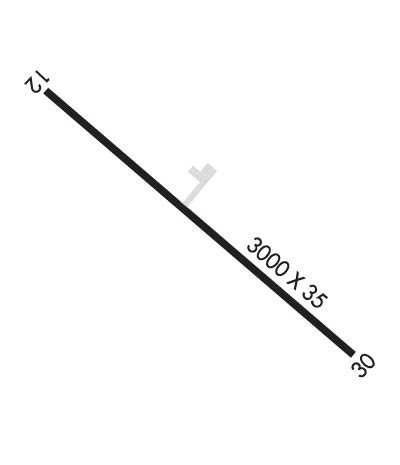
| Lat: N 3645.5 Long: W 09906.1 Elev: 1517 Var: -08 Longest Runway: 3000 | ||
| CTAF: 122.9 | ||
| ||||||||||||||||||||||||||||||||
| ||||||||||||||||||||||||||||||||
| Rwy | Rwy | |||||||
| 3000x35 | 3000' | 3000x35 | 3000' | |||||
| Runway ID | Single Wheel | Double Wheel | Double Tandem Wheel | Dual Double Wheel |
| 12/30 | N/A | N/A | N/A | N/A |
| These numbers are Advisory and are not limits. The Airport Manager should have more accurate Weight Limits | ||||
| FltPlan does not have IFR approach charts available for KK77. |
 Airport Diagram might not be current. | |
| Facility Name: | FREEDOM MUNI |
| City Name: | FREEDOM |
| County: | WOODS |
| State abbrev: | OK |
| State Name: | OKLAHOMA |
| Ownership: | PUBLICLY OWNED |
| Use: | OPEN TO THE PUBLIC |
| Owner's Name: | TOWN OF FREEDOM |
| Address: | 1149 MAIN ST |
| FREEDOM, OK 73842 | |
| Owner's Phone: | 580-621-3302 |
| Manager's Name: | SHAD BRACKIN; MAYOR |
| Address: | P. O. BOX 173 |
| FREEDOM, OK 73842 | |
| Phone: | (580) 621-3302 |
| FAA Region: | SOUTHWEST |
| FAA Field Office: | AOK |
| Date | Sunrise | Sunset |
|---|---|---|
| 09/24/21 Friday | 7:26 | 19:31 |
| 09/25/21 Saturday | 7:27 | 19:29 |
| 09/26/21 Sunday | 7:27 | 19:28 |
| 09/27/21 Monday | 7:28 | 19:26 |
| 09/28/21 Tuesday | 7:29 | 19:25 |
| 09/29/21 Wednesday | 7:30 | 19:23 |
| 09/30/21 Thursday | 7:31 | 19:22 |
| 10/01/21 Friday | 7:31 | 19:20 |
| 10/02/21 Saturday | 7:32 | 19:19 |
| 10/03/21 Sunday | 7:33 | 19:17 |
| 10/04/21 Monday | 7:34 | 19:16 |
| 10/05/21 Tuesday | 7:35 | 19:14 |
| 10/06/21 Wednesday | 7:36 | 19:13 |
| 10/07/21 Thursday | 7:37 | 19:11 |
| Airport Attendance Schedule | UNATTENDED |
| Airport Status | OPERATIONAL (This Status can change at any time - please check NOTAMS) |
| Airport Lighting Schedule | |
| Airport Storage Available | NONE |
| Extra Services Available | NONE |
| Wind Indicator | NONE |
| Control Tower | NO |
| CTAF Frequency | 122.900 |
| Unicom Frequency | |
| Rotating Beacon Color | |
| Segmented Circle | NO |
| Landing Fee | NO |
| Airport Inspected | STATE - performed by STATE AERONAUTICAL PERSONNEL |
| Inspection Date | 04/21/2021 |
| Type of Fuel Available | None |
| Airframe Repair Service | NONE |
| Power Plant Repair Service | NONE |
| Latitude | N3645.5 |
| Longitude | W09906.1 (ESTIMATED) |
| Arpt Elevation | 1517ft (SURVEYED) |
| Magnetic Variation | 08E |
| 1 miles SE | of FREEDOM |
| Traffic Pattern Altitude | |
| Sectional Chart | WICHITA |
| Operations (Reported) | Yearly | Avg. Daily |
|---|---|---|
| General Aviation Transient | 30 | 0 |
| General Aviation Local | 0 | 0 |
| Air Taxi | 0 | 0 |
| Commerical | 0 | 0 |
| Commuter | 0 | 0 |
| Military | 0 | 0 |
| Aircraft based on Field | |
|---|---|
| General Aviation Singles | 0 |
| General Aviation Multi | 0 |
| Jet Aircraft | 0 |
| General Aviation Helicopters | 0 |
| Military Aircraft | 0 |
| Gliders | 0 |
| Ultralights | 0 |
| FSS on field | NO |
| FSS tie-in | MC ALESTER |
| FSS Phone | 1-800-WX-BRIEF |
| Who issues Notams | MLC |
| Notam D service at airport | YES |
| ARTCC Name | KANSAS CITY |
| Airport Certification | |
| Aircraft Rescue & Firefighting Index | None |
| Airport of Entry | No |
| Custom Landing Rights | No |
| Joint Civil/Military | No |
| Military Landing rights | No |
| FOR CD CTC KANSAS CITY ARTCC AT 913-254-8508. |
| RWY 12/3 0 RY EDGES/THLDS UNIDENTIFIABLE. FIRST 150 FT OF RY 12 END AND FIRST 400 FT OF RY 30 END COVERED IN GRASS. RY SFC ROUGH AND UNEVEN. BROKEN ASPH CHUNKS, ROCKS, AND TALL GRASS ON ENTIRE SURFACE. |
| Runway: 12 | Runway: 30 | ||
| Mag heading: | N/A | Mag heading: | N/A |
| Approach: | Approach: | ||
| Pattern: | Left Traffic | Pattern: | Left Traffic |
| Markings: | Markings: | ||
| Marking Condition: | Marking Condition: | ||
| Arresting Dev: | Arresting Dev: | ||
| Lat & Long: | Lat. & Long.: | ||
| Elev: | N/A | Elev: | N/A |
| TCH: | TCH: | ||
| Visual Glide Path: | Visual Glide Path: | ||
| Displaced Threshold: | No | Displaced Threshold: | No |
| Touchdown Zone: | NO | Touchdown Zone: | NO |
| Touchdown Elev.: | Touchdown Elev.: | ||
| Visual Glide Slope: | Visual Glide Slope: | ||
| RVR Equipment: | RVR Equipment: | ||
| RVV Equipment: | NO | RVV Equipment: | NO |
| Approach Lights: | Approach Lights: | ||
| REIL: | NO | REIL: | NO |
| Centerline Lights: | NO | Centerline Lights: | NO |
| Touchdown lights: | NO | Touchdown lights: | NO |
| Runway Category: | Runway with a Visual Approach | Runway Category: | Runway with a Visual Approach |
| Declared Distances: | Declared Distances: | ||
| Obstructions: | TREES | Obstructions: | TREES |
| Marked: | NOT Marked/Lighted | Marked: | NOT Marked/Lighted |
| Clearance slope: | 1:1 | Clearance slope: | 11:1 |
| Obstruction height: | 46 feet AGL | Obstruction height: | 35 feet AGL |
| Dist. from runway: | 246 feet | Dist. from runway: | 606 feet |
| Centerline offset: | 65 left of centerline | Centerline offset: | |
| Comments: | 15 FT TREES 190 FT FM THLD 90 FT L OF CNTRLN. | Comments: |
Thanks for using FltPlan.com
all rights reserved © 1999-2021 by Flight Plan LLC
