
| HAMRY FIELD KINDRED ND |
| |
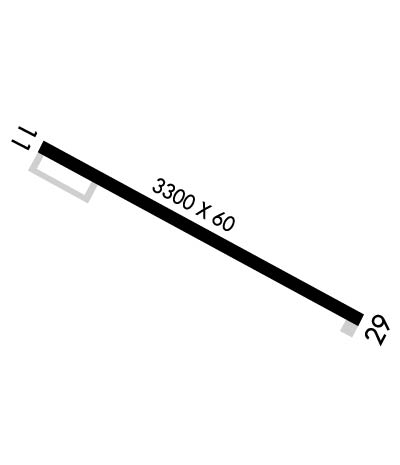
| Lat: N 4638.9 Long: W 09659.9 Elev: 947 Var: -04 Longest Runway: 3300 | ||
| CTAF: 122.9 | ||
| ||||||||||||||||||||||||||||||||
| ||||||||||||||||||||||||||||||||
| Rwy | Rwy | |||||||
| 3300x60 | 3300' | 3300x60 | 3300' | |||||
| Runway ID | Single Wheel | Double Wheel | Double Tandem Wheel | Dual Double Wheel |
| 11/29 | N/A | N/A | N/A | N/A |
| These numbers are Advisory and are not limits. The Airport Manager should have more accurate Weight Limits | ||||
 Airport Diagram might not be current. | |
| Facility Name: | ROBERT ODEGAARD FLD |
| City Name: | KINDRED |
| County: | CASS |
| State abbrev: | ND |
| State Name: | NORTH DAKOTA |
| Ownership: | PUBLICLY OWNED |
| Use: | OPEN TO THE PUBLIC |
| Owner's Name: | KINDRED-DAVENPORT REGIONAL APT AUTH |
| Address: | 111 1ST AVE N |
| KINDRED, ND 58051 | |
| Owner's Phone: | 701-428-9990 |
| Manager's Name: | CASEY ODEGAARD; ADL CTC KELLY PERHUS (CHAIRMAN): 701-238-2305. |
| Address: | 111 1ST AVE N |
| KINDRED, ND 58051 | |
| Phone: | 701-367-6710 |
| FAA Region: | GREAT LAKES |
| FAA Field Office: | DMA |
| Date | Sunrise | Sunset |
|---|---|---|
| 09/24/21 Friday | 7:17 | 19:22 |
| 09/25/21 Saturday | 7:18 | 19:20 |
| 09/26/21 Sunday | 7:20 | 19:18 |
| 09/27/21 Monday | 7:21 | 19:16 |
| 09/28/21 Tuesday | 7:22 | 19:14 |
| 09/29/21 Wednesday | 7:24 | 19:12 |
| 09/30/21 Thursday | 7:25 | 19:10 |
| 10/01/21 Friday | 7:26 | 19:08 |
| 10/02/21 Saturday | 7:28 | 19:06 |
| 10/03/21 Sunday | 7:29 | 19:04 |
| 10/04/21 Monday | 7:30 | 19:02 |
| 10/05/21 Tuesday | 7:32 | 19:00 |
| 10/06/21 Wednesday | 7:33 | 18:58 |
| 10/07/21 Thursday | 7:34 | 18:56 |
| Airport Attendance Schedule | MON-FRI 0800-1730; FOR SVC AFT HRS CALL (701) 367-6710. |
| Airport Status | OPERATIONAL (This Status can change at any time - please check NOTAMS) |
| Airport Lighting Schedule | DUSK-2330; RY 11/29 ACTVT CTAF 122.9 FOR MIRL AND PAPI AFTER 2330 HOUR. |
| Airport Storage Available | Tie Downs, Hanger |
| Extra Services Available | Crop Dusting, Flight Instruction, Aircraft Sales |
| Wind Indicator | YES - (lighted) |
| Control Tower | NO |
| CTAF Frequency | 122.900 |
| Unicom Frequency | |
| Rotating Beacon Color | |
| Segmented Circle | YES |
| Landing Fee | NO |
| Airport Inspected | STATE - performed by STATE AERONAUTICAL PERSONNEL |
| Inspection Date | 08/05/2020 |
| Type of Fuel Available | Grade 100LL; -10SELF SERVICE FUEL AVBL 24 HRS WITH CREDIT CARD. |
| Airframe Repair Service | MAJOR; AIRCRAFT REPAIR SHOP CTC ODEGAARD WINGS AT 701-428-3457. |
| Power Plant Repair Service | MAJOR |
| Latitude | N4638.9 |
| Longitude | W09659.9 (ESTIMATED) |
| Arpt Elevation | 947ft (SURVEYED) |
| Magnetic Variation | 04E |
| 1 miles E | of KINDRED |
| Traffic Pattern Altitude | |
| Sectional Chart | TWIN CITIES |
| Operations (Reported) | Yearly | Avg. Daily |
|---|---|---|
| General Aviation Transient | 2500 | 7 |
| General Aviation Local | 3400 | 9 |
| Air Taxi | 50 | 0 |
| Commerical | 0 | 0 |
| Commuter | 0 | 0 |
| Military | 50 | 0 |
| Aircraft based on Field | |
|---|---|
| General Aviation Singles | 24 |
| General Aviation Multi | 3 |
| Jet Aircraft | 0 |
| General Aviation Helicopters | 0 |
| Military Aircraft | 3 |
| Gliders | 0 |
| Ultralights | 0 |
| FSS on field | NO |
| FSS tie-in | GRAND FORKS |
| FSS Phone | 1-800-WX-BRIEF |
| Who issues Notams | GFK |
| Notam D service at airport | YES |
| ARTCC Name | MINNEAPOLIS |
| Airport Certification | |
| Aircraft Rescue & Firefighting Index | None |
| Airport of Entry | No |
| Custom Landing Rights | No |
| Joint Civil/Military | No |
| Military Landing rights | No |
| NATIONAL PLAN OF INTEGRATED AIRPORT SYSTEMS (NPIAS) |
| BIRDS & DEER ON OR INVOF ARPT. |
| RY 11/29 CONFIRM WITH AMGR FOR SNOW REMOVAL PRIOR TO USE AFT WINTER STORMS. |
| FOR CD CTC FARGO APCH AT 701-235-8894. |
Airport Communications & Frequencies:
| ||||||||||||
| Runway: 11 | Runway: 29 | ||
| Mag heading: | 114° | Mag heading: | 294° |
| Rwy Slope: | -.11% Down | Rwy Slope: | .11% Up |
| Approach: | Approach: | ||
| Pattern: | Left Traffic | Pattern: | Left Traffic |
| Markings: | NONPRECISION INSTRUMENT | Markings: | NONPRECISION INSTRUMENT |
| Marking Condition: | GOOD | Marking Condition: | GOOD |
| Arresting Dev: | Arresting Dev: | ||
| Lat & Long: | N4639.1 W09700.3 | Lat. & Long.: | N4638.8 W09659.6 |
| Elev: | 947.3 ft. MSL | Elev: | 943.8 ft. MSL |
| TCH: | 25 ft. AGL | TCH: | 25 ft. AGL |
| Visual Glide Path: | 3.00 degrees | Visual Glide Path: | 3.00 degrees |
| Displaced Threshold: | No | Displaced Threshold: | No |
| Touchdown Zone: | YES | Touchdown Zone: | YES |
| Touchdown Elev.: | 947.3 feet | Touchdown Elev.: | 947.0 feet |
| Visual Glide Slope: | 2-Light PAPI on LEFT side of Runway | Visual Glide Slope: | 2-Light PAPI on LEFT side of Runway |
| RVR Equipment: | RVR Equipment: | ||
| RVV Equipment: | NO | RVV Equipment: | NO |
| Approach Lights: | Approach Lights: | ||
| REIL: | NO | REIL: | NO |
| Centerline Lights: | NO | Centerline Lights: | NO |
| Touchdown lights: | NO | Touchdown lights: | NO |
| Runway Category: | Runway with a Non-precision Approach | Runway Category: | Runway with a Non-precision Approach |
| Declared Distances: | Declared Distances: |
Thanks for using FltPlan.com
all rights reserved © 1999-2021 by Flight Plan LLC
