
| LE ROY LE ROY NY |
| |
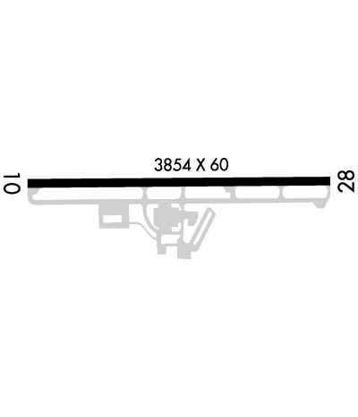
| Lat: N 4258.9 Long: W 07756.1 Elev: 780 Var: +11 Longest Runway: 3854 | ||
| CTAF: 122.8 | ||
| ||||||||||||||||||||||||||||||||
| ||||||||||||||||||||||||||||||||
| Rwy | Rwy | |||||||
| 3854x60 | 3854' | 3854x60 | 3854' | |||||
| Runway ID | Single Wheel | Double Wheel | Double Tandem Wheel | Dual Double Wheel |
| 10/28 | 12,500 | N/A | N/A | N/A |
| These numbers are Advisory and are not limits. The Airport Manager should have more accurate Weight Limits | ||||
 Airport Diagram might not be current. | |
| Facility Name: | LE ROY |
| City Name: | LE ROY |
| County: | GENESEE |
| State abbrev: | NY |
| State Name: | NEW YORK |
| Ownership: | PRIVATELY OWNED |
| Use: | OPEN TO THE PUBLIC |
| Owner's Name: | LEROY AVIATION SERVICES INC |
| Address: | 8267 EAST MAIN ROAD |
| LE ROY, NY 14482 | |
| Owner's Phone: | 585-768-4560 |
| Manager's Name: | RAY DETOR |
| Address: | 283 WESTMINSTER ROAD |
| ROCHESTER, NY 14607-3229 | |
| Phone: | 585-259-9308 |
| FAA Region: | EASTERN |
| FAA Field Office: | NYC |

| Date | Sunrise | Sunset |
|---|---|---|
| 07/18/26 Saturday | 5:49 | 20:47 |
| 07/19/26 Sunday | 5:50 | 20:46 |
| 07/20/26 Monday | 5:50 | 20:45 |
| 07/21/26 Tuesday | 5:51 | 20:44 |
| 07/22/26 Wednesday | 5:52 | 20:44 |
| 07/23/26 Thursday | 5:53 | 20:43 |
| 07/24/26 Friday | 5:54 | 20:42 |
| 07/25/26 Saturday | 5:55 | 20:41 |
| 07/26/26 Sunday | 5:56 | 20:40 |
| 07/27/26 Monday | 5:57 | 20:39 |
| 07/28/26 Tuesday | 5:58 | 20:38 |
| 07/29/26 Wednesday | 5:59 | 20:37 |
| 07/30/26 Thursday | 6:00 | 20:35 |
| 07/31/26 Friday | 6:01 | 20:34 |
| Airport Attendance Schedule | MON-FRI 1000-1600; EXCP MAJOR HOL. |
| Airport Status | OPERATIONAL (This Status can change at any time - please check NOTAMS) |
| Airport Lighting Schedule | SS-SR, ACTVT REIL RWY 10 & 28; PAPI RWY 10 & 28; MIRL RWY 10/28 - CTAF. |
| Airport Storage Available | Tie Downs, Hanger |
| Extra Services Available | Flight Instruction, Aircraft Rental, Aircraft Sales |
| Wind Indicator | YES - (lighted) |
| Control Tower | NO |
| CTAF Frequency | 122.800 |
| Unicom Frequency | 122.800 |
| Rotating Beacon Color | WG |
| Segmented Circle | NO |
| Landing Fee | NO |
| Airport Inspected | STATE - performed by PRIVATE CONTRACT PERSONNEL |
| Inspection Date | 07/13/2024 |
| Type of Fuel Available | Grade 100LL |
| Airframe Repair Service | MINOR |
| Power Plant Repair Service | MINOR |
| Latitude | N4258.9 |
| Longitude | W07756.1 (ESTIMATED) |
| Arpt Elevation | 780ft (SURVEYED) |
| Magnetic Variation | 11W |
| 2 miles E | of LE ROY |
| Traffic Pattern Altitude | |
| Sectional Chart | DETROIT |
| Operations (Reported) | Yearly | Avg. Daily |
|---|---|---|
| General Aviation Transient | 0 | 0 |
| General Aviation Local | 0 | 0 |
| Air Taxi | 0 | 0 |
| Commerical | 0 | 0 |
| Commuter | 0 | 0 |
| Military | 0 | 0 |
| Aircraft based on Field | |
|---|---|
| General Aviation Singles | 0 |
| General Aviation Multi | 0 |
| Jet Aircraft | 0 |
| General Aviation Helicopters | 0 |
| Military Aircraft | 0 |
| Gliders | 0 |
| Ultralights | 0 |
| FSS on field | NO |
| FSS tie-in | BUFFALO |
| FSS Phone | 1-800-WX-BRIEF |
| Who issues Notams | BUF |
| Notam D service at airport | YES |
| ARTCC Name | CLEVELAND |
| Airport Certification | |
| Aircraft Rescue & Firefighting Index | None |
| Airport of Entry | No |
| Custom Landing Rights | No |
| Joint Civil/Military | No |
| Military Landing rights | No |
| NATIONAL PLAN OF INTEGRATED AIRPORT SYSTEMS (NPIAS) |
| DEER ON AND INVOF ARPT. |
| FOR CD CTC CLEVELAND ARTCC AT 440-774-0490. |
Airport Communications & Frequencies:
| ||||||||||||||
| Runway: 10 | Runway: 28 | ||
| Mag heading: | 104° | Mag heading: | 284° |
| Rwy Slope: | -.04% Down | Rwy Slope: | .04% Up |
| Approach: | Approach: | ||
| Pattern: | Left Traffic | Pattern: | Left Traffic |
| Markings: | NONPRECISION INSTRUMENT | Markings: | NONPRECISION INSTRUMENT |
| Marking Condition: | FAIR | Marking Condition: | FAIR |
| Arresting Dev: | Arresting Dev: | ||
| Lat & Long: | N4258.9 W07756.5 | Lat. & Long.: | N4258.9 W07755.7 |
| Elev: | 780.0 ft. MSL | Elev: | 778.3 ft. MSL |
| TCH: | 31 ft. AGL | TCH: | 53 ft. AGL |
| Visual Glide Path: | 3.00 degrees | Visual Glide Path: | 3.50 degrees |
| Displaced Threshold: | No | Displaced Threshold: | No |
| Touchdown Zone: | YES | Touchdown Zone: | YES |
| Touchdown Elev.: | 780.3 feet | Touchdown Elev.: | 778.3 feet |
| Visual Glide Slope: | 2-Light PAPI on LEFT side of Runway | Visual Glide Slope: | 2-Light PAPI on LEFT side of Runway |
| RVR Equipment: | RVR Equipment: | ||
| RVV Equipment: | NO | RVV Equipment: | NO |
| Approach Lights: | Approach Lights: | ||
| REIL: | YES | REIL: | YES |
| Centerline Lights: | NO | Centerline Lights: | NO |
| Touchdown lights: | NO | Touchdown lights: | NO |
| Runway Category: | Runway with a Non-precision Approach | Runway Category: | Runway with a Non-precision Approach |
| Declared Distances: | Declared Distances: | ||
| Obstructions: | TREE | Obstructions: | FENCE |
| Marked: | NOT Marked/Lighted | Marked: | NOT Marked/Lighted |
| Clearance slope: | 30 FT TREES; 320 FT DTSC, 100 FT RIGHT. | Clearance slope: | |
| Obstruction height: | 40 feet AGL | Obstruction height: | 8 feet AGL |
| Dist. from runway: | 214 feet | Dist. from runway: | 201 feet |
| Centerline offset: | 220 left of centerline | Centerline offset: | 100 feet right of centerline |
| Comments: | 8 FT FENCE; 0-199 FT DSTC, 94 FT LEFT. | Comments: | 8 FT FENCE; 0-199 FT DSTC, 100 FT RIGHT. |
Thanks for using FltPlan.com
all rights reserved © 1999-2026 by Flight Plan LLC