
| MONROE CITY RGNL MONROE CITY MO |
| |
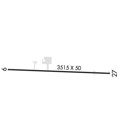
| Lat: N 3938.1 Long: W 09143.6 Elev: 737 Var: -01 Longest Runway: 3515 | ||
| CTAF: 122.8 | ||
| ||||||||||||||||||||||||||||||||||||||||||||
| ||||||||||||||||||||||||||||||||||||||||||||
| Rwy | Rwy | |||||||
| 3515x50 | 3515' | 3515x50 | 3515' | |||||
| Runway ID | Single Wheel | Double Wheel | Double Tandem Wheel | Dual Double Wheel |
| 09/27 | 16,000 | N/A | N/A | N/A |
| These numbers are Advisory and are not limits. The Airport Manager should have more accurate Weight Limits | ||||
 Airport Diagram might not be current. | |
| Facility Name: | CPT BEN SMITH AIRFIELD - MONROE CITY |
| City Name: | MONROE CITY |
| County: | MONROE |
| State abbrev: | MO |
| State Name: | MISSOURI |
| Ownership: | PUBLICLY OWNED |
| Use: | OPEN TO THE PUBLIC |
| Owner's Name: | CITY OF MONROE |
| Address: | 109 2ND ST., BOX 67 |
| MONROE CITY, MO 63456 | |
| Owner's Phone: | 573-735-4845 |
| Manager's Name: | RUTH MAUPIN |
| Address: | 109 2ND ST., BOX 67 |
| MONROE CITY, MO 63456 | |
| Phone: | (573) 406-5444; AIRPORT OFFICE PHONE (573) 735-4845. |
| FAA Region: | CENTRAL |
| FAA Field Office: | NONE |
| Date | Sunrise | Sunset |
|---|---|---|
| 09/24/21 Friday | 6:56 | 19:01 |
| 09/25/21 Saturday | 6:57 | 18:59 |
| 09/26/21 Sunday | 6:58 | 18:58 |
| 09/27/21 Monday | 6:59 | 18:56 |
| 09/28/21 Tuesday | 7:00 | 18:55 |
| 09/29/21 Wednesday | 7:01 | 18:53 |
| 09/30/21 Thursday | 7:02 | 18:51 |
| 10/01/21 Friday | 7:03 | 18:50 |
| 10/02/21 Saturday | 7:04 | 18:48 |
| 10/03/21 Sunday | 7:05 | 18:46 |
| 10/04/21 Monday | 7:06 | 18:45 |
| 10/05/21 Tuesday | 7:07 | 18:43 |
| 10/06/21 Wednesday | 7:08 | 18:42 |
| 10/07/21 Thursday | 7:09 | 18:40 |
| Airport Attendance Schedule | MON-FRI 0800-1700, SAT 0800-1200 |
| Airport Status | OPERATIONAL (This Status can change at any time - please check NOTAMS) |
| Airport Lighting Schedule | DUSK-DAWN. MIRL RY 09/27 PRESET LOW INTST; TO INCR INTST & ACTVT PAPI RYS 09 & 27 - CTAF. |
| Airport Storage Available | Tie Downs |
| Extra Services Available | NONE |
| Wind Indicator | YES - (lighted) |
| Control Tower | NO |
| CTAF Frequency | 122.800 |
| Unicom Frequency | 122.800 |
| Rotating Beacon Color | CLEAR-GREEN (Light Land Airport) |
| Segmented Circle | YES |
| Landing Fee | NO |
| Airport Inspected | STATE - performed by STATE AERONAUTICAL PERSONNEL |
| Inspection Date | 09/03/2020 |
| Type of Fuel Available | Grade 100LL |
| Airframe Repair Service | None |
| Power Plant Repair Service | None |
| Latitude | N3938.1 |
| Longitude | W09143.6 (ESTIMATED) |
| Arpt Elevation | 737ft (SURVEYED) |
| Magnetic Variation | 01E |
| 1 miles S | of MONROE CITY |
| Traffic Pattern Altitude | 965; TPA LIGHT ACFT 800 FT AGL, TURBO PROP AND JETS 1500 FT AGL |
| Sectional Chart | KANSAS CITY |
| Operations (Reported) | Yearly | Avg. Daily |
|---|---|---|
| General Aviation Transient | 1000 | 3 |
| General Aviation Local | 1000 | 3 |
| Air Taxi | 50 | 0 |
| Commerical | 0 | 0 |
| Commuter | 0 | 0 |
| Military | 10 | 0 |
| Aircraft based on Field | |
|---|---|
| General Aviation Singles | 2 |
| General Aviation Multi | 0 |
| Jet Aircraft | 0 |
| General Aviation Helicopters | 0 |
| Military Aircraft | 0 |
| Gliders | 0 |
| Ultralights | 0 |
| FSS on field | NO |
| FSS tie-in | SAINT LOUIS |
| FSS Phone | 1-800-WX-BRIEF |
| Who issues Notams | STL |
| Notam D service at airport | YES |
| ARTCC Name | KANSAS CITY |
| Airport Certification | |
| Aircraft Rescue & Firefighting Index | None |
| Airport of Entry | No |
| Custom Landing Rights | No |
| Joint Civil/Military | No |
| Military Landing rights | No |
| THIS AIRPORT HAS BEEN SURVEYED BY THE NATIONAL GEODETIC SURVEY. |
| FOR CD CTC KANSAS CITY ARTCC AT 913-254-8508. |
Airport Communications & Frequencies:
| |||||||||
| Runway: 09 | Runway: 27 | ||
| Mag heading: | 91° | Mag heading: | 271° |
| Rwy Slope: | -.07% Down | Rwy Slope: | .07% Up |
| Approach: | Approach: | ||
| Pattern: | Left Traffic | Pattern: | Left Traffic |
| Markings: | NONPRECISION INSTRUMENT | Markings: | NONPRECISION INSTRUMENT |
| Marking Condition: | GOOD | Marking Condition: | GOOD |
| Arresting Dev: | Arresting Dev: | ||
| Lat & Long: | N3938.1 W09144.0 | Lat. & Long.: | N3938.1 W09143.2 |
| Elev: | 736.6 ft. MSL | Elev: | 734.2 ft. MSL |
| TCH: | 38 ft. AGL | TCH: | 39 ft. AGL |
| Visual Glide Path: | 3.00 degrees | Visual Glide Path: | 3.00 degrees |
| Displaced Threshold: | No | Displaced Threshold: | No |
| Touchdown Zone: | YES | Touchdown Zone: | YES |
| Touchdown Elev.: | 737.1 feet | Touchdown Elev.: | 737.1 feet |
| Visual Glide Slope: | 2-Light PAPI on LEFT side of Runway | Visual Glide Slope: | 2-Light PAPI on LEFT side of Runway |
| RVR Equipment: | RVR Equipment: | ||
| RVV Equipment: | NO | RVV Equipment: | NO |
| Approach Lights: | Approach Lights: | ||
| REIL: | NO | REIL: | NO |
| Centerline Lights: | NO | Centerline Lights: | NO |
| Touchdown lights: | NO | Touchdown lights: | NO |
| Runway Category: | Runway with a Non-precision Approach | Runway Category: | Runway with a Non-precision Approach |
| Declared Distances: | Declared Distances: | ||
| Obstructions: | POLE | Obstructions: | TREES |
| Marked: | NOT Marked/Lighted | Marked: | NOT Marked/Lighted |
| Clearance slope: | 14:1 | Clearance slope: | 10:1 |
| Obstruction height: | 20 feet AGL | Obstruction height: | 21 feet AGL |
| Dist. from runway: | 495 feet | Dist. from runway: | 425 feet |
| Centerline offset: | 145 right of centerline | Centerline offset: | 125 feet right of centerline |
| Comments: | +1-4' FENCE 0-200' FM RY END 120'R. | Comments: | 1-5 FT FENCE 65-200 FT FM RY END & 120 FT R; 1-5 FT FENCE 0-200 FT FM RY END & 125 FT L. |
Thanks for using FltPlan.com
all rights reserved © 1999-2021 by Flight Plan LLC
