
| MEDICINE LODGE MEDICINE LODGE KS |
| |
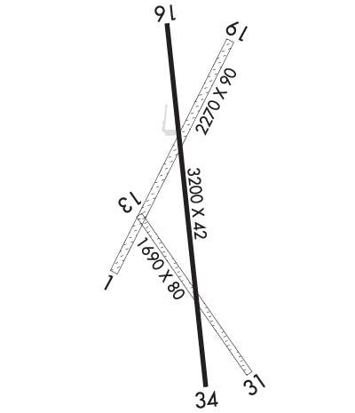
| Lat: N 3715.9 Long: W 09832.9 Elev: 1549 Var: -07 Longest Runway: 3200 | ||
| AWOS: 119.6 CTAF: 122.9 | ||
| ||||||||||||||||||||||||||||||||
| ||||||||||||||||||||||||||||||||
| ||||||||||||||||||||||||||||||||
| Rwy | Rwy | |||||||
| 1690x80 | 1690' | 1690x80 | 1690' | |||||
| 3200x42 | 3200' | 3200x42 | 3000' | |||||
| Runway ID | Single Wheel | Double Wheel | Double Tandem Wheel | Dual Double Wheel |
| 13/31 | N/A | N/A | N/A | N/A |
| 16/34 | N/A | N/A | N/A | N/A |
| These numbers are Advisory and are not limits. The Airport Manager should have more accurate Weight Limits | ||||
| FltPlan does not have IFR approach charts available for KK51. |
 Airport Diagram might not be current. | |
| Facility Name: | MEDICINE LODGE |
| City Name: | MEDICINE LODGE |
| County: | BARBER |
| State abbrev: | KS |
| State Name: | KANSAS |
| Ownership: | PUBLICLY OWNED |
| Use: | OPEN TO THE PUBLIC |
| Owner's Name: | MEDICINE LODGE |
| Address: | 114 W. 1ST STREET |
| MEDICINE LODGE, KS 67104 | |
| Owner's Phone: | 620-886-3908 |
| Manager's Name: | JEFF PORTER |
| Address: | 114 W 1ST ST. |
| MEDICINE LODGE, KS 67104 | |
| Phone: | 620-886-3908 |
| FAA Region: | CENTRAL |
| FAA Field Office: | NONE |
| Date | Sunrise | Sunset |
|---|---|---|
| 09/24/21 Friday | 7:23 | 19:28 |
| 09/25/21 Saturday | 7:24 | 19:27 |
| 09/26/21 Sunday | 7:25 | 19:25 |
| 09/27/21 Monday | 7:26 | 19:24 |
| 09/28/21 Tuesday | 7:27 | 19:22 |
| 09/29/21 Wednesday | 7:28 | 19:21 |
| 09/30/21 Thursday | 7:29 | 19:19 |
| 10/01/21 Friday | 7:29 | 19:18 |
| 10/02/21 Saturday | 7:30 | 19:16 |
| 10/03/21 Sunday | 7:31 | 19:15 |
| 10/04/21 Monday | 7:32 | 19:13 |
| 10/05/21 Tuesday | 7:33 | 19:12 |
| 10/06/21 Wednesday | 7:34 | 19:10 |
| 10/07/21 Thursday | 7:35 | 19:09 |
| Airport Attendance Schedule | UNATTENDED; FOR SERVICE & ARPT INFO CALL SHERIFF 620-886-5678. |
| Airport Status | OPERATIONAL (This Status can change at any time - please check NOTAMS) |
| Airport Lighting Schedule | SS-SR |
| Airport Storage Available | Tie Downs |
| Extra Services Available | NONE |
| Wind Indicator | YES - (lighted) |
| Control Tower | NO |
| CTAF Frequency | 122.900 |
| Unicom Frequency | |
| Rotating Beacon Color | CLEAR-GREEN (Light Land Airport) |
| Segmented Circle | NO |
| Landing Fee | NO |
| Airport Inspected | STATE - performed by STATE AERONAUTICAL PERSONNEL |
| Inspection Date | 06/26/2020 |
| Type of Fuel Available | None |
| Airframe Repair Service | NONE |
| Power Plant Repair Service | NONE |
| Latitude | N3715.9 |
| Longitude | W09832.9 (ESTIMATED) |
| Arpt Elevation | 1549ft (ESTIMATED) |
| Magnetic Variation | 07E |
| 3 miles SE | of MEDICINE LODGE |
| Traffic Pattern Altitude | |
| Sectional Chart | WICHITA |
| Operations (Reported) | Yearly | Avg. Daily |
|---|---|---|
| General Aviation Transient | 1200 | 3 |
| General Aviation Local | 1200 | 3 |
| Air Taxi | 0 | 0 |
| Commerical | 0 | 0 |
| Commuter | 0 | 0 |
| Military | 0 | 0 |
| Aircraft based on Field | |
|---|---|
| General Aviation Singles | 0 |
| General Aviation Multi | 0 |
| Jet Aircraft | 0 |
| General Aviation Helicopters | 0 |
| Military Aircraft | 0 |
| Gliders | 0 |
| Ultralights | 0 |
| FSS on field | NO |
| FSS tie-in | WICHITA |
| FSS Phone | 1-800-WX-BRIEF |
| Who issues Notams | ICT |
| Notam D service at airport | YES |
| ARTCC Name | KANSAS CITY |
| Airport Certification | |
| Aircraft Rescue & Firefighting Index | None |
| Airport of Entry | No |
| Custom Landing Rights | No |
| Joint Civil/Military | No |
| Military Landing rights | No |
| NATIONAL PLAN OF INTEGRATED AIRPORT SYSTEMS (NPIAS) |
| AWOS 398 FT. LEFT RY 16 |
| FOR CD CTC KANSAS CITY ARTCC AT 913-254-8508. |
| 25' WIDE BY 430' LONG ASPH TWY 140' SOUTH OF THE AER 16. TO A 80' X 145' APRON |
| Runway: 13 | Runway: 31 | ||
| Mag heading: | 138° | Mag heading: | 318° |
| Rwy Slope: | -.65% Down | Rwy Slope: | .65% Up |
| Approach: | Approach: | ||
| Pattern: | Left Traffic | Pattern: | Left Traffic |
| Markings: | Markings: | ||
| Marking Condition: | Marking Condition: | ||
| Arresting Dev: | Arresting Dev: | ||
| Lat & Long: | N3716.0 W09833.0 | Lat. & Long.: | N3715.7 W09832.8 |
| Elev: | 1522.0 ft. MSL | Elev: | 1511.0 ft. MSL |
| TCH: | TCH: | ||
| Visual Glide Path: | Visual Glide Path: | ||
| Displaced Threshold: | No | Displaced Threshold: | No |
| Touchdown Zone: | NO | Touchdown Zone: | NO |
| Touchdown Elev.: | Touchdown Elev.: | ||
| Visual Glide Slope: | Visual Glide Slope: | ||
| RVR Equipment: | RVR Equipment: | ||
| RVV Equipment: | NO | RVV Equipment: | NO |
| Approach Lights: | Approach Lights: | ||
| REIL: | NO | REIL: | NO |
| Centerline Lights: | NO | Centerline Lights: | NO |
| Touchdown lights: | NO | Touchdown lights: | NO |
| Runway Category: | Runway with a Visual Approach | Runway Category: | Runway with a Visual Approach |
| Declared Distances: | Declared Distances: | ||
| Obstructions: | TREES | Obstructions: | FENCE |
| Marked: | NOT Marked/Lighted | Marked: | NOT Marked/Lighted |
| Clearance slope: | 8:1 | Clearance slope: | |
| Obstruction height: | 25 feet AGL | Obstruction height: | 6 feet AGL |
| Dist. from runway: | 200 feet | Dist. from runway: | 0 feet |
| Centerline offset: | Centerline offset: | ||
| Comments: | Comments: |
| Runway: 16 | Runway: 34 | ||
| Mag heading: | 167° | Mag heading: | 347° |
| Rwy Slope: | -1.28% Down | Rwy Slope: | 1.28% Up |
| Approach: | Approach: | ||
| Pattern: | Left Traffic | Pattern: | Left Traffic |
| Markings: | BASIC | Markings: | BASIC |
| Marking Condition: | GOOD | Marking Condition: | GOOD |
| Arresting Dev: | Arresting Dev: | ||
| Lat & Long: | N3716.2 W09832.9 | Lat. & Long.: | N3715.7 W09832.8 |
| Elev: | 1549.0 ft. MSL | Elev: | 1508.0 ft. MSL |
| TCH: | TCH: | ||
| Visual Glide Path: | Visual Glide Path: | ||
| Displaced Threshold: | No | Displaced Threshold: | 200 feet |
| Touchdown Zone: | NO | Touchdown Zone: | NO |
| Touchdown Elev.: | Touchdown Elev.: | ||
| Visual Glide Slope: | Visual Glide Slope: | ||
| RVR Equipment: | RVR Equipment: | ||
| RVV Equipment: | NO | RVV Equipment: | NO |
| Approach Lights: | Approach Lights: | ||
| REIL: | NO | REIL: | NO |
| Centerline Lights: | NO | Centerline Lights: | NO |
| Touchdown lights: | NO | Touchdown lights: | NO |
| Runway Category: | Runway with a Visual Approach | Runway Category: | Runway with a Visual Approach |
| Declared Distances: | TORA:3200' TODA:3200' | Declared Distances: | TORA:3200' TODA:3200' |
| Obstructions: | HILL | Obstructions: | |
| Marked: | NOT Marked/Lighted | Marked: | |
| Clearance slope: | Clearance slope: | 50:1 | |
| Obstruction height: | 15 feet AGL | Obstruction height: | |
| Dist. from runway: | 201 feet | Dist. from runway: | |
| Centerline offset: | Centerline offset: | ||
| Comments: | 15 FT HILL 160-200 FT FM RY END; 25 FT TREE 50 FT R & 160 FT FM RY END. | Comments: | 5 FT FENCE 160 FT FROM RY END. |
Thanks for using FltPlan.com
all rights reserved © 1999-2021 by Flight Plan LLC
