| Rwy | Length | Land Dist Avail** | Approach* | | Rwy | Length | Land Dist Avail** | Approach* | | 06 | 5500x75 | 5500' | | | 24 | 5500x75 | 5010' | | | * only ILS, LOC, LDA, and SDF approaches to a specific runway are shown** For any Declared Landing Distance Available, please see A/FD or Approach plates |
| Runway Weight Capability (lbs.) more info on Runway Weight Capability | | Runway ID | Single Wheel | Double Wheel | Double Tandem Wheel | Dual Double Wheel | These numbers are Advisory and are not limits. The Airport Manager should have more accurate Weight Limits
Please email Support@FltPlan.com for further information. |
| Approach Charts FltPlan does not have IFR approaches charts available for K4A7. |
|
| Customs Information ( Send updates to Support@FltPlan.com ) |
| Database effective date: 07/21/2016 |
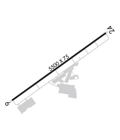
Airport Diagram might not be current.
| | Facility Name: | ATLANTA SOUTH RGNL | | City Name: | ATLANTA | | County: | HENRY | | State abbrev: | GA | | State Name: | GEORGIA | | | | | Ownership: | PUBLICLY OWNED | | Use: | OPEN TO THE PUBLIC | | Owner's Name: | HENRY COUNTY | | Address: | 140 HENRY PARKWAY | | | MCCONOUGH, GA 30253 | | Owner's Phone: | 770-288-6000 | | | | | Manager's Name: | MICHAEL TONEY | | Address: | 474 SPEEDWAY BLVE | | | HAMPTON, GA 30228 | | Phone: | 770-288-7829; MAIN ARPT PHONE 770-288-7829. | | | | | FAA Region: | SOUTHERN | | FAA Field Office: | ATL |
| 

Click here for full scale & interactive Sectional view of K4A7
|
| Sunrise / Sunset times for: ATLANTA SOUTH RGNL | | Date: | Sunrise | Sunset | | 09/14/16 Wednesday | 7:21 | 19:44 | | 09/15/16 Thursday | 7:21 | 19:43 | | 09/16/16 Friday | 7:22 | 19:41 | | 09/17/16 Saturday | 7:23 | 19:40 | | 09/18/16 Sunday | 7:23 | 19:38 | | 09/19/16 Monday | 7:24 | 19:37 | | 09/20/16 Tuesday | 7:25 | 19:36 |
| : | | Date: | Sunrise | Sunset | | 09/21/16 Wednesday | 7:25 | 19:34 | | 09/22/16 Thursday | 7:26 | 19:33 | | 09/23/16 Friday | 7:27 | 19:32 | | 09/24/16 Saturday | 7:27 | 19:30 | | 09/25/16 Sunday | 7:28 | 19:29 | | 09/26/16 Monday | 7:29 | 19:27 | | 09/27/16 Tuesday | 7:29 | 19:26 |
|
|
| Airport Facilities | Airport Attendance Schedule: MON-FRI 0800-1700
Airport Status: OPERATIONAL (This Status can change at any time - please check NOTAMS)
Airport Lighting Schedule: ACTVT MIRL RY 06/24 AND PAPI RYS 06 & 24 - CTAF. MIRL OPER DUSK-DAWN ONLY.
Airport Storage Available: Tie Downs
Extra Services Available: Charter, Flight Instruction, Aircraft Rental, Aircraft Sales
Wind Indicator: YES - (lighted)Control Tower: NO
CTAF Frequency: 122.725
Unicom Frequency: 122.725 | Rotating Beacon Color: CLEAR-GREEN (Light Land Airport)
Segmented Circle: YES | | Landing Fee: ACFT PARKING FEE RQRD ON MAJOR RACE DAYS. | |
|
| Airport Services | Type of Fuel Available: Grade 100LL, JET A-1 (icing inhibitor, freeze point -50C); FUEL 24 HR SELF-SERVE WITH CREDIT CARD. FUEL CALL OUT AVBL
Airframe Repair Service: MAJOR
Power Plant Repair Service: MAJOR |
|
| Geographic Data | | Latitude: N3323.4 Longitude: W08419.9 (ESTIMATED) | | Arpt Elevation: 882ft (SURVEYED) | | | Magnetic Variation: 03W | | 3 miles W of ATLANTA | | Traffic Pattern Altitude: | | Sectional Chart: ATLANTA |
|
| Aircraft Data | | Operations (reported) | Yearly | Avg. Daily | | General Aviation transient: | 5000 | 14 | | General Aviation Local: | 5000 | 14 | | Air Taxi: | 1500 | 4 | | Commerical: | 0 | 0 | | Commuter: | 0 | 0 | | Military: | 0 | 0 |
| | Aircraft based on Field | | General Aviation Singles: | 55 | | General Aviation Multi: | 12 | | Jet Aircraft: | 2 | | General Aviation Helicopters: | 13 | | Military Aircraft: | 0 | | Gliders: | 0 | | Ultralights: | 3 |
|
|
| FAA Services | FSS on field: NO
FSS tie-in:MACON
FSS Phone: 1-800-WX-BRIEFWho issues Notams: MCN
Notam D service at airport: YES
ARTCC Name: ATLANTA | |
|
|
| Federal Status | Airport Certification:
Aircraft Rescue & Firefighting Index: NoneAirport of Entry: No
Custom Landing Rights: No | Joint Civil/Military: No
Military Landing rights: No | |
|
|
Runway Identification: 06/24Length: 5500 ft
Width: 75 ft
Surface: ASPHALT-GOOD CONDITION
Edge lights: Medium Intensity
|
| |
| | Mag heading: | 57° | Mag heading: | 237° | | Rwy Slope: | .55% Up | Rwy Slope: | -.55% Down | | Approach: | | Approach: | | | Pattern: | Right Traffic | Pattern: | Left Traffic | | Markings: | NONPRECISION INSTRUMENT | Markings: | NONPRECISION INSTRUMENT | | Marking Condition: | GOOD | Marking Condition: | GOOD | | Arresting Dev: | | Arresting Dev: | | | Lat & Long: | N3323.1 W08420.3 | Lat. & Long.: | N3323.7 W08419.4 | | Elev: | 852.0 ft. MSL | Elev: | 882.0 ft. MSL | | TCH: | 44 ft. AGL | TCH: | 44 ft. AGL | | Visual Glide Path: | 3.00 degrees | Visual Glide Path: | 3.00 degrees | | Displaced Threshold: | No | Displaced Threshold: | 490 feet | | Touchdown Zone: | YES | Touchdown Zone: | YES | | Touchdown Elev.: | 860.9 feet | Touchdown Elev.: | 882.0 feet | | Visual Glide Slope: | 2-Light PAPI on LEFT side of Runway | Visual Glide Slope: | 2-Light PAPI on LEFT side of Runway | | RVR Equipment: | | RVR Equipment: | | | RVV Equipment: | NO | RVV Equipment: | NO | | Approach Lights: | | Approach Lights: | | | REIL: | NO | REIL: | NO | | Centerline Lights: | NO | Centerline Lights: | NO | | Touchdown lights: | NO | Touchdown lights: | NO | | Runway Category: | Runway with a Non-precision Approach having visibility minimums greater than 3/4 mile | Runway Category: | Runway with a Non-precision Approach having visibility minimums greater than 3/4 mile | | Declared Distances: | | Declared Distances: | | | Obstructions: | TREES | Obstructions: | ROAD | | Marked: | NOT Marked/Lighted | Marked: | NOT Marked/Lighted | | Clearance slope: | 34:1; APPROACH SLOPE 50:1 AT DISPLACED THRESHOLD | Clearance slope: | 4:1 | | Obstruction height: | 32 feet AGL | Obstruction height: | 12 feet AGL | | Dist. from runway: | 1288 feet | Dist. from runway: | 248 feet | | Centerline offset: | 187 left of centerline | Centerline offset: | | | Comments: | | Comments: | |
|
| Remarks | | THIS AIRPORT HAS BEEN SURVEYED BY THE NATIONAL GEODETIC SURVEY.ACROBATIC TRNG & DMSTN AREA SW OF ARPT.DEER ON & INVOF ARPT.AIRCRAFT OVERNIGHT PARKING FEE. |
|
| Federal Agreements | | NATIONAL PLAN OF INTEGRATED AIRPORT SYSTEMS (NPIAS)ASSURANCES PURSUANT TO TITLE VI, CIVIL RIGHTS ACT OF 1964 |
|
| Airport Inspection Data | Airport Inspected: STATE - performed by STATE AERONAUTICAL PERSONNEL
Inspection Date: 05/29/2015 |
|
25/16/18
Thanks for using FltPlan.com
all rights reserved © copyright 1999-2016 by Flight Plan LLC |