
| MUNICIPAL TEXHOMA OK |
| |
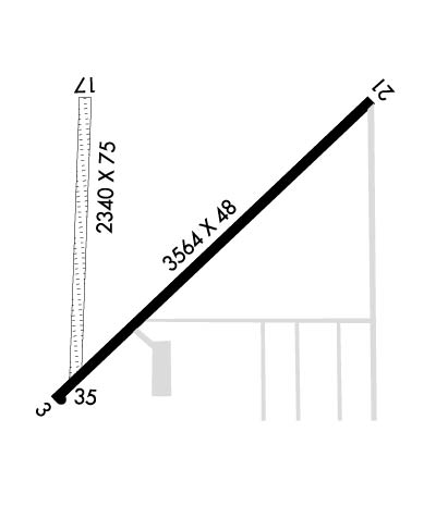
| Lat: N 3630.3 Long: W 10148.8 Elev: 3462 Var: -09 Longest Runway: 3564 | ||
| CTAF: 122.9 | ||
| ||||||||||||||||||||||||||||||||||||||||||||
| ||||||||||||||||||||||||||||||||||||||||||||
| Rwy | Rwy | |||||||
| 3564x48 | 2974' | 3564x48 | 3224' | |||||
| 2340x75 | 2340' | 2340x75 | 2340' | |||||
| Runway ID | Single Wheel | Double Wheel | Double Tandem Wheel | Dual Double Wheel |
| 03/21 | N/A | N/A | N/A | N/A |
| 17/35 | N/A | N/A | N/A | N/A |
| These numbers are Advisory and are not limits. The Airport Manager should have more accurate Weight Limits | ||||
| FltPlan does not have IFR approach charts available for KK49. |
 Airport Diagram might not be current. | |
| Facility Name: | TEXHOMA MUNI |
| City Name: | TEXHOMA |
| County: | TEXAS |
| State abbrev: | OK |
| State Name: | OKLAHOMA |
| Ownership: | PUBLICLY OWNED |
| Use: | OPEN TO THE PUBLIC |
| Owner's Name: | CITY OF TEXHOMA |
| Address: | CITY HALL |
| TEXHOMA, OK 73949 | |
| Owner's Phone: | 580-423-7341 |
| Manager's Name: | TERRY HAGER; AIRPORT BOARD CHAIRMAN. |
| Address: | PO BOX 588 |
| TEXHOMA, OK 73949 | |
| Phone: | 806-753-6567 |
| FAA Region: | SOUTHWEST |
| FAA Field Office: | AOK |
| Date | Sunrise | Sunset |
|---|---|---|
| 09/24/21 Friday | 7:37 | 19:41 |
| 09/25/21 Saturday | 7:37 | 19:40 |
| 09/26/21 Sunday | 7:38 | 19:38 |
| 09/27/21 Monday | 7:39 | 19:37 |
| 09/28/21 Tuesday | 7:40 | 19:35 |
| 09/29/21 Wednesday | 7:41 | 19:34 |
| 09/30/21 Thursday | 7:41 | 19:32 |
| 10/01/21 Friday | 7:42 | 19:31 |
| 10/02/21 Saturday | 7:43 | 19:30 |
| 10/03/21 Sunday | 7:44 | 19:28 |
| 10/04/21 Monday | 7:45 | 19:27 |
| 10/05/21 Tuesday | 7:46 | 19:25 |
| 10/06/21 Wednesday | 7:46 | 19:24 |
| 10/07/21 Thursday | 7:47 | 19:22 |
| Airport Attendance Schedule | UNATTENDED |
| Airport Status | CLOSED INDEFINITELY (This Status can change at any time - please check NOTAMS) |
| Airport Lighting Schedule | ACTVT MIRL RWY 03/21 - CTAF. |
| Airport Storage Available | NONE |
| Extra Services Available | Crop Dusting |
| Wind Indicator | YES - (unlit) |
| Control Tower | NO |
| CTAF Frequency | 122.900 |
| Unicom Frequency | |
| Rotating Beacon Color | |
| Segmented Circle | NO |
| Landing Fee | NO |
| Airport Inspected | STATE - performed by STATE AERONAUTICAL PERSONNEL |
| Inspection Date | 11/26/2019 |
| Type of Fuel Available | Grade 100LL; -10FOR FUEL CALL 580-522-2009. |
| Airframe Repair Service | NONE |
| Power Plant Repair Service | NONE |
| Latitude | N3630.3 |
| Longitude | W10148.8 (ESTIMATED) |
| Arpt Elevation | 3462ft (SURVEYED) |
| Magnetic Variation | 09E |
| 1 miles W | of TEXHOMA |
| Traffic Pattern Altitude | |
| Sectional Chart | WICHITA |
| Operations (Reported) | Yearly | Avg. Daily |
|---|---|---|
| General Aviation Transient | 50 | 0 |
| General Aviation Local | 500 | 1 |
| Air Taxi | 0 | 0 |
| Commerical | 0 | 0 |
| Commuter | 0 | 0 |
| Military | 0 | 0 |
| Aircraft based on Field | |
|---|---|
| General Aviation Singles | 8 |
| General Aviation Multi | 2 |
| Jet Aircraft | 0 |
| General Aviation Helicopters | 0 |
| Military Aircraft | 0 |
| Gliders | 0 |
| Ultralights | 0 |
| FSS on field | NO |
| FSS tie-in | MC ALESTER |
| FSS Phone | 1-800-WX-BRIEF |
| Who issues Notams | MLC |
| Notam D service at airport | YES |
| ARTCC Name | ALBUQUERQUE |
| Airport Certification | |
| Aircraft Rescue & Firefighting Index | None |
| Airport of Entry | No |
| Custom Landing Rights | No |
| Joint Civil/Military | No |
| Military Landing rights | No |
| ULTRALIGHT ACTIVITY ON & INVOF ARPT. |
| WIND TURBINES 350 FT AGL LOCATED 2 MILES SOUTH OF AIRPORT. |
| FOR CD CTC ALBUQUERQUE ARTCC AT 505-856-4861. |
| (ARPT STATUS) ARPT CLSD INDEFLY. |
| RWY 03/2 1 MIRL OTS INDEFLY. |
| Runway: 03 | Runway: 21 | ||
| Mag heading: | N/A | Mag heading: | N/A |
| Approach: | Approach: | ||
| Pattern: | Left Traffic | Pattern: | Left Traffic |
| Markings: | Markings: | ||
| Marking Condition: | RWY 03/21 NOT MKD. | Marking Condition: | |
| Arresting Dev: | Arresting Dev: | ||
| Lat & Long: | N3630.1 W10149.0 | Lat. & Long.: | N3630.5 W10148.4 |
| Elev: | N/A | Elev: | N/A |
| TCH: | TCH: | ||
| Visual Glide Path: | Visual Glide Path: | ||
| Displaced Threshold: | 590 feet | Displaced Threshold: | 340 feet |
| Touchdown Zone: | NO | Touchdown Zone: | NO |
| Touchdown Elev.: | Touchdown Elev.: | ||
| Visual Glide Slope: | Visual Glide Slope: | ||
| RVR Equipment: | RVR Equipment: | ||
| RVV Equipment: | NO | RVV Equipment: | NO |
| Approach Lights: | Approach Lights: | ||
| REIL: | NO | REIL: | NO |
| Centerline Lights: | NO | Centerline Lights: | NO |
| Touchdown lights: | NO | Touchdown lights: | NO |
| Runway Category: | Runway with a Visual Approach | Runway Category: | Runway with a Visual Approach |
| Declared Distances: | Declared Distances: | ||
| Obstructions: | ROAD | Obstructions: | FENCE |
| Marked: | NOT Marked/Lighted | Marked: | NOT Marked/Lighted |
| Clearance slope: | APCH SLOPE 35:1 TO DTHR; 15 FT ROAD 530 FT FM DTHR 155 FT LEFT OF CNTRLN. | Clearance slope: | |
| Obstruction height: | 15 feet AGL | Obstruction height: | 4 feet AGL |
| Dist. from runway: | 200 feet | Dist. from runway: | 200 feet |
| Centerline offset: | 75 left of centerline | Centerline offset: | 100 feet right of centerline |
| Comments: | +15 FT ROAD 0 FT FM PAVEMENT END, 115 FT R OF CNTRLN & 105 FT L OF CNTRLN; +4 FT FENCE & +5 FT ROAD SIGNS 80 FT FM PAVEMENT END & 0B. | Comments: | +4 FT FENCE 0 FT FM PAVEMENT END 100 FT L OF CNTRLN & 115 FT R OF CNTRLN. |
| Runway: 17 | Runway: 35 | ||
| Mag heading: | N/A | Mag heading: | N/A |
| Approach: | Approach: | ||
| Pattern: | Left Traffic | Pattern: | Left Traffic |
| Markings: | Markings: | ||
| Marking Condition: | Marking Condition: | ||
| Arresting Dev: | Arresting Dev: | ||
| Lat & Long: | Lat. & Long.: | ||
| Elev: | N/A | Elev: | N/A |
| TCH: | TCH: | ||
| Visual Glide Path: | Visual Glide Path: | ||
| Displaced Threshold: | No | Displaced Threshold: | No |
| Touchdown Zone: | NO | Touchdown Zone: | NO |
| Touchdown Elev.: | Touchdown Elev.: | ||
| Visual Glide Slope: | Visual Glide Slope: | ||
| RVR Equipment: | RVR Equipment: | ||
| RVV Equipment: | NO | RVV Equipment: | NO |
| Approach Lights: | Approach Lights: | ||
| REIL: | NO | REIL: | NO |
| Centerline Lights: | NO | Centerline Lights: | NO |
| Touchdown lights: | NO | Touchdown lights: | NO |
| Runway Category: | Runway with a Visual Approach | Runway Category: | Runway with a Visual Approach |
| Declared Distances: | Declared Distances: | ||
| Obstructions: | FENCE | Obstructions: | ROAD |
| Marked: | NOT Marked/Lighted | Marked: | NOT Marked/Lighted |
| Clearance slope: | 2:1 | Clearance slope: | 27:1 |
| Obstruction height: | 4 feet AGL | Obstruction height: | 15 feet AGL |
| Dist. from runway: | 10 feet | Dist. from runway: | 412 feet |
| Centerline offset: | Centerline offset: | ||
| Comments: | Comments: |
Thanks for using FltPlan.com
all rights reserved © 1999-2021 by Flight Plan LLC
