
| SKY PARK (CLOSED) RED HOOK NY |
| |
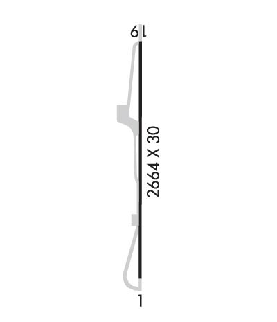
| Lat: N 4159.1 Long: W 07350.2 Elev: 323 Var: +12 Longest Runway: 2664 | ||
| CTAF: 122.9 | ||
| ||||||||||||||||||||||||||||||||
| ||||||||||||||||||||||||||||||||
| Rwy | Rwy | |||||||
| 2664x30 | 2664' | 2664x30 | 2664' | |||||
| Runway ID | Single Wheel | Double Wheel | Double Tandem Wheel | Dual Double Wheel |
| 01/19 | 30,000 | N/A | N/A | N/A |
| These numbers are Advisory and are not limits. The Airport Manager should have more accurate Weight Limits | ||||
| FltPlan does not have IFR approach charts available for K46N. |
 Airport Diagram might not be current. | |
| Facility Name: | SKY PARK |
| City Name: | RED HOOK |
| County: | DUTCHESS |
| State abbrev: | NY |
| State Name: | NEW YORK |
| Ownership: | PRIVATELY OWNED |
| Use: | OPEN TO THE PUBLIC |
| Owner's Name: | SKY PARK DEVELOPERS LLC |
| Address: | PO BOX 567 |
| MONSEY, NY 10952 | |
| Owner's Phone: | (914)380-3903 |
| Manager's Name: | AVI WOLBE |
| Address: | 21 LOCUST HOLLOW DR |
| MONSEY, NY 10952 | |
| Phone: | 845 538 5664 |
| FAA Region: | EASTERN |
| FAA Field Office: | NYC |
| Date | Sunrise | Sunset |
|---|---|---|
| 07/07/21 Wednesday | 5:27 | 20:33 |
| 07/08/21 Thursday | 5:28 | 20:33 |
| 07/09/21 Friday | 5:28 | 20:32 |
| 07/10/21 Saturday | 5:29 | 20:32 |
| 07/11/21 Sunday | 5:30 | 20:32 |
| 07/12/21 Monday | 5:30 | 20:31 |
| 07/13/21 Tuesday | 5:31 | 20:31 |
| 07/14/21 Wednesday | 5:32 | 20:30 |
| 07/15/21 Thursday | 5:33 | 20:29 |
| 07/16/21 Friday | 5:34 | 20:29 |
| 07/17/21 Saturday | 5:34 | 20:28 |
| 07/18/21 Sunday | 5:35 | 20:27 |
| 07/19/21 Monday | 5:36 | 20:27 |
| 07/20/21 Tuesday | 5:37 | 20:26 |
| Airport Attendance Schedule | UNATTENDED |
| Airport Status | CLOSED INDEFINITELY (This Status can change at any time - please check NOTAMS) |
| Airport Lighting Schedule | |
| Airport Storage Available | Tie Downs |
| Extra Services Available | NONE |
| Wind Indicator | NONE |
| Control Tower | NO |
| CTAF Frequency | 122.900 |
| Unicom Frequency | |
| Rotating Beacon Color | |
| Segmented Circle | NO |
| Landing Fee | NO |
| Airport Inspected | STATE - performed by STATE AERONAUTICAL PERSONNEL |
| Inspection Date | 07/21/2020 |
| Type of Fuel Available | None |
| Airframe Repair Service | NONE |
| Power Plant Repair Service | NONE |
| Latitude | N4159.1 |
| Longitude | W07350.2 (ESTIMATED) |
| Arpt Elevation | 323ft (SURVEYED) |
| Magnetic Variation | 12W |
| 2 miles E | of RED HOOK |
| Traffic Pattern Altitude | |
| Sectional Chart | NEW YORK |
| Operations (Reported) | Yearly | Avg. Daily |
|---|---|---|
| General Aviation Transient | 0 | 0 |
| General Aviation Local | 0 | 0 |
| Air Taxi | 0 | 0 |
| Commerical | 0 | 0 |
| Commuter | 0 | 0 |
| Military | 0 | 0 |
| Aircraft based on Field | |
|---|---|
| General Aviation Singles | 0 |
| General Aviation Multi | 0 |
| Jet Aircraft | 0 |
| General Aviation Helicopters | 0 |
| Military Aircraft | 0 |
| Gliders | 0 |
| Ultralights | 0 |
| FSS on field | NO |
| FSS tie-in | NEW YORK |
| FSS Phone | 1-800-WX-BRIEF |
| Who issues Notams | ISP |
| Notam D service at airport | YES |
| ARTCC Name | BOSTON |
| Airport Certification | |
| Aircraft Rescue & Firefighting Index | None |
| Airport of Entry | No |
| Custom Landing Rights | No |
| Joint Civil/Military | No |
| Military Landing rights | No |
| RY SAFETY AREAS HAVE DROPOFFS & ROUGH TERRAIN. |
| AIRPORT ACCESS ROAD GATE LOCKED. CALL AT LEAST THREE (3) HOURS PRIOR MINIMUM FOR PPR AT 914-380-3903. |
| FOR CD CTC NEW YORK APCH AT 516-683-2448. |
| (ARPT STATUS) ARPT CLSD INDEFLY. |
| RWY 01/1 9 DETERIORATED PAVEMENT HAS LARGE POTHOLES, LOOSE AGGREGATE AND TALL VEGETATION THROUGHOUT SURFACE OF TAXIWAY AND RUNWAY. |
Airport Communications & Frequencies:
| ||||||||||||
| Runway: 01 | Runway: 19 | ||
| Mag heading: | 13° | Mag heading: | 193° |
| Rwy Slope: | -.26% Down | Rwy Slope: | .26% Up |
| Approach: | Approach: | ||
| Pattern: | Left Traffic | Pattern: | Left Traffic |
| Markings: | Markings: | ||
| Marking Condition: | Marking Condition: | ||
| Arresting Dev: | Arresting Dev: | ||
| Lat & Long: | N4158.9 W07350.2 | Lat. & Long.: | N4159.3 W07350.2 |
| Elev: | 323.0 ft. MSL | Elev: | 316.0 ft. MSL |
| TCH: | TCH: | ||
| Visual Glide Path: | Visual Glide Path: | ||
| Displaced Threshold: | No | Displaced Threshold: | No |
| Touchdown Zone: | YES | Touchdown Zone: | YES |
| Touchdown Elev.: | 323.0 feet | Touchdown Elev.: | 323.0 feet |
| Visual Glide Slope: | Visual Glide Slope: | ||
| RVR Equipment: | RVR Equipment: | ||
| RVV Equipment: | NO | RVV Equipment: | NO |
| Approach Lights: | Approach Lights: | ||
| REIL: | NO | REIL: | NO |
| Centerline Lights: | NO | Centerline Lights: | NO |
| Touchdown lights: | NO | Touchdown lights: | NO |
| Runway Category: | Runway with a Non-precision Approach | Runway Category: | Runway with a Visual Approach |
| Declared Distances: | Declared Distances: | ||
| Obstructions: | TREES | Obstructions: | TREES |
| Marked: | NOT Marked/Lighted | Marked: | NOT Marked/Lighted |
| Clearance slope: | Clearance slope: | ||
| Obstruction height: | 50 feet AGL | Obstruction height: | 43 feet AGL |
| Dist. from runway: | 200 feet | Dist. from runway: | 221 feet |
| Centerline offset: | 85 right of centerline | Centerline offset: | 23 feet right of centerline |
| Comments: | RY 01 30-70 FT TREES, 10-100FT LEFT & RIGHT OF THLD, AND 0-200 FT FM RY END. | Comments: | RWY 19 40 FT TREES 40 FT L & R OF CNTRLN 0-200 FT FM THLD. |
Thanks for using FltPlan.com
all rights reserved © 1999-2021 by Flight Plan LLC
