
| BELOIT BELOIT WI |
| |
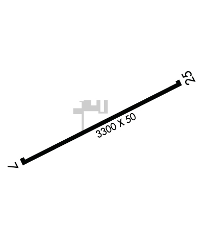
| Lat: N 4229.9 Long: W 08858.1 Elev: 817 Var: +03 Longest Runway: 3300 | ||
| CTAF: 122.7 | ||
| ||||||||||||||||||||||||||||||||||||||||||||
| ||||||||||||||||||||||||||||||||||||||||||||
| Rwy | Rwy | |||||||
| 3300x50 | 3300' | 3300x50 | 2950' | |||||
| Runway ID | Single Wheel | Double Wheel | Double Tandem Wheel | Dual Double Wheel |
| 07/25 | 12,500 | N/A | N/A | N/A |
| These numbers are Advisory and are not limits. The Airport Manager should have more accurate Weight Limits | ||||
 Airport Diagram might not be current. | |
| Facility Name: | BELOIT |
| City Name: | BELOIT |
| County: | ROCK |
| State abbrev: | WI |
| State Name: | WISCONSIN |
| Ownership: | PRIVATELY OWNED |
| Use: | OPEN TO THE PUBLIC |
| Owner's Name: | STEVE STAUBER |
| Address: | 4046 STATE HWY 67 |
| BELOIT, WI 53511 | |
| Owner's Phone: | 773-914-9938 |
| Manager's Name: | STEVE STAUBER |
| Address: | 4046 STATE HWY 67; EMAIL ADDRESS: SHSTAUBER@AOL.COM (ALL LOWER CASE) |
| BELOIT, WI 53511 | |
| Phone: | 773-914-9938 |
| FAA Region: | GREAT LAKES |
| FAA Field Office: | CHI |
| Date | Sunrise | Sunset |
|---|---|---|
| 05/15/26 Friday | 5:34 | 20:11 |
| 05/16/26 Saturday | 5:33 | 20:12 |
| 05/17/26 Sunday | 5:32 | 20:13 |
| 05/18/26 Monday | 5:31 | 20:14 |
| 05/19/26 Tuesday | 5:30 | 20:15 |
| 05/20/26 Wednesday | 5:29 | 20:16 |
| 05/21/26 Thursday | 5:29 | 20:17 |
| 05/22/26 Friday | 5:28 | 20:18 |
| 05/23/26 Saturday | 5:27 | 20:19 |
| 05/24/26 Sunday | 5:26 | 20:20 |
| 05/25/26 Monday | 5:25 | 20:21 |
| 05/26/26 Tuesday | 5:25 | 20:21 |
| 05/27/26 Wednesday | 5:24 | 20:22 |
| 05/28/26 Thursday | 5:23 | 20:23 |
| Airport Attendance Schedule | MAY-AUG MON-FRI 1000-1400 |
| Airport Status | OPERATIONAL (This Status can change at any time - please check NOTAMS) |
| Airport Lighting Schedule | ACTVT LIRL RY 07/25 - CTAF. |
| Airport Storage Available | Tie Downs, Hanger |
| Extra Services Available | Parachute Jumping |
| Wind Indicator | YES - (lighted) |
| Control Tower | NO |
| CTAF Frequency | 122.700 |
| Unicom Frequency | 122.700 |
| Rotating Beacon Color | WG |
| Segmented Circle | NO |
| Landing Fee | NO |
| Airport Inspected | STATE - performed by STATE AERONAUTICAL PERSONNEL |
| Inspection Date | 05/29/2025 |
| Type of Fuel Available | Grade 100LL |
| Airframe Repair Service | NONE |
| Power Plant Repair Service | NONE |
| Latitude | N4229.9 |
| Longitude | W08858.1 (ESTIMATED) |
| Arpt Elevation | 817ft (SURVEYED) |
| Magnetic Variation | 03W |
| 3 miles E | of BELOIT |
| Traffic Pattern Altitude | 700 |
| Sectional Chart | CHICAGO |
| Operations (Reported) | Yearly | Avg. Daily |
|---|---|---|
| General Aviation Transient | 0 | 0 |
| General Aviation Local | 0 | 0 |
| Air Taxi | 0 | 0 |
| Commerical | 0 | 0 |
| Commuter | 0 | 0 |
| Military | 0 | 0 |
| Aircraft based on Field | |
|---|---|
| General Aviation Singles | 0 |
| General Aviation Multi | 0 |
| Jet Aircraft | 0 |
| General Aviation Helicopters | 0 |
| Military Aircraft | 0 |
| Gliders | 0 |
| Ultralights | 0 |
| FSS on field | NO |
| FSS tie-in | GREEN BAY |
| FSS Phone | 1-800-WX-BRIEF |
| Who issues Notams | GRB |
| Notam D service at airport | YES |
| ARTCC Name | CHICAGO |
| Airport Certification | |
| Aircraft Rescue & Firefighting Index | None |
| Airport of Entry | No |
| Custom Landing Rights | No |
| Joint Civil/Military | No |
| Military Landing rights | No |
| FOR CD CTC CHICAGO ARTCC AT 630-906-8921. |
| (DSPLCD THR APCH RATIO, RWY 25) APCH RTIO 10:1 TO DSPLCD THLD; 54 FT SILO 560 FT FM DSPLCD THLD 190 FT R. |
| RWY 07/2 5 NSTD LIRL 100 FT WIDE; 50 FT LEFT & RIGHT OF RY CNTRLN. |
Airport Communications & Frequencies:
| ||||||||||||||
| Runway: 07 | Runway: 25 | ||
| Mag heading: | 67° | Mag heading: | 247° |
| Rwy Slope: | .27% Up | Rwy Slope: | -.27% Down |
| Approach: | Approach: | ||
| Pattern: | Left Traffic | Pattern: | Left Traffic |
| Markings: | NONSTANDARD | Markings: | BASIC |
| Marking Condition: | GOOD; NSTD THR MARKINGS; LCTD 92 FT FM END OF PAVEMENT. | Marking Condition: | GOOD |
| Arresting Dev: | Arresting Dev: | ||
| Lat & Long: | N4229.7 W08858.4 | Lat. & Long.: | N4230.0 W08857.7 |
| Elev: | 802.0 ft. MSL | Elev: | 811.0 ft. MSL |
| TCH: | TCH: | ||
| Visual Glide Path: | Visual Glide Path: | ||
| Displaced Threshold: | No | Displaced Threshold: | 350 feet |
| Touchdown Zone: | YES | Touchdown Zone: | YES |
| Touchdown Elev.: | 817.0 feet | Touchdown Elev.: | 817.0 feet |
| Visual Glide Slope: | Visual Glide Slope: | ||
| RVR Equipment: | RVR Equipment: | ||
| RVV Equipment: | NO | RVV Equipment: | NO |
| Approach Lights: | Approach Lights: | ||
| REIL: | NO | REIL: | NO |
| Centerline Lights: | NO | Centerline Lights: | NO |
| Touchdown lights: | NO | Touchdown lights: | NO |
| Runway Category: | Runway with a Visual Approach | Runway Category: | Runway with a Visual Approach |
| Declared Distances: | Declared Distances: | ||
| Obstructions: | Obstructions: | ROAD | |
| Marked: | Marked: | NOT Marked/Lighted | |
| Clearance slope: | 20:1 | Clearance slope: | APCH RATIO 20:1 TO DTHR. |
| Obstruction height: | Obstruction height: | 15 feet AGL | |
| Dist. from runway: | Dist. from runway: | 200 feet | |
| Centerline offset: | Centerline offset: | 65 feet right of centerline | |
| Comments: | Comments: | 15 FT ROAD 0 - 200 FT FM RWY END; 65 - 110 FT R. |
Thanks for using FltPlan.com
all rights reserved © 1999-2026 by Flight Plan LLC
