
| PALATKA MUNI - LT. KAY LARKIN PALATKA FL |
| |
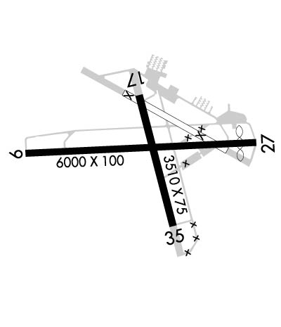
| Lat: N 2939.5 Long: W 08141.4 Elev: 48 Var: +05 Longest Runway: 6000 | ||
| AWOS: 119.92 CTAF: 122.8 | ||
| ||||||||||||||||||||||||||||||||||||||||||||
| ||||||||||||||||||||||||||||||||||||||||||||
| ||||||||||||||||||||||||||||||||||||||||||||
| Rwy | Rwy | |||||||
| 6000x100 | 6000' | 6000x100 | 5550' | |||||
| 3804x75 | 3509' | 3804x75 | 3804' | |||||
| Runway ID | Single Wheel | Double Wheel | Double Tandem Wheel | Dual Double Wheel |
| 09/27 | 79,000 | 116,000 | N/A | N/A |
| 17/35 | 61,000 | 87,000 | N/A | N/A |
| These numbers are Advisory and are not limits. The Airport Manager should have more accurate Weight Limits | ||||
 Airport Diagram might not be current. | |
| Facility Name: | PALATKA MUNI/LT KAY LARKIN FLD |
| City Name: | PALATKA |
| County: | PUTNAM |
| State abbrev: | FL |
| State Name: | FLORIDA |
| Ownership: | PUBLICLY OWNED |
| Use: | OPEN TO THE PUBLIC |
| Owner's Name: | CITY OF PALATKA; ARPT PHYS ADS: 4015 REID STREET; 386-329-0148. |
| Address: | 201 NORTH 2ND ST |
| PALATKA, FL 32177 | |
| Owner's Phone: | 386-329-0100 |
| Manager's Name: | YUL MCNAIR |
| Address: | 4015 REID ST, HWY 100 |
| PALATKA, FL 32177 | |
| Phone: | 386-329-0149 |
| FAA Region: | SOUTHERN |
| FAA Field Office: | ORL |

| Date | Sunrise | Sunset |
|---|---|---|
| 07/28/26 Tuesday | 6:44 | 20:22 |
| 07/29/26 Wednesday | 6:44 | 20:22 |
| 07/30/26 Thursday | 6:45 | 20:21 |
| 07/31/26 Friday | 6:46 | 20:20 |
| 08/01/26 Saturday | 6:46 | 20:20 |
| 08/02/26 Sunday | 6:47 | 20:19 |
| 08/03/26 Monday | 6:47 | 20:18 |
| 08/04/26 Tuesday | 6:48 | 20:17 |
| 08/05/26 Wednesday | 6:49 | 20:17 |
| 08/06/26 Thursday | 6:49 | 20:16 |
| 08/07/26 Friday | 6:50 | 20:15 |
| 08/08/26 Saturday | 6:50 | 20:14 |
| 08/09/26 Sunday | 6:51 | 20:13 |
| 08/10/26 Monday | 6:52 | 20:12 |
| Airport Attendance Schedule | 7 Days A Week 0800-1800 |
| Airport Status | OPERATIONAL (This Status can change at any time - please check NOTAMS) |
| Airport Lighting Schedule | ACTVT REIL RWY 09 & 27; PAPI RWY 09, 27, 17 & 35; MIRL RWY 09/27 & 17/35 - CTAF. |
| Airport Storage Available | Tie Downs |
| Extra Services Available | Flight Instruction, Parachute Jumping, Aircraft Rental |
| Wind Indicator | YES - (lighted) |
| Control Tower | NO |
| CTAF Frequency | 122.800 |
| Unicom Frequency | 122.800 |
| Rotating Beacon Color | WG |
| Segmented Circle | Y-L; WND CONE CIRCLED CONCRETE. |
| Landing Fee | NO |
| Airport Inspected | STATE - performed by STATE AERONAUTICAL PERSONNEL |
| Inspection Date | 02/09/2026 |
| Type of Fuel Available | Grade 100LL, JET A (freeze point -40C); -10CREDIT CARD FUEL AVBL 24 HRS. |
| Airframe Repair Service | MINOR |
| Power Plant Repair Service | MAJOR |
| Latitude | N2939.5 |
| Longitude | W08141.4 (ESTIMATED) |
| Arpt Elevation | 47ft (SURVEYED) |
| Magnetic Variation | 05W |
| 2 miles NW | of PALATKA |
| Traffic Pattern Altitude | |
| Sectional Chart | JACKSONVILLE |
| Operations (Reported) | Yearly | Avg. Daily |
|---|---|---|
| General Aviation Transient | 0 | 0 |
| General Aviation Local | 0 | 0 |
| Air Taxi | 0 | 0 |
| Commerical | 0 | 0 |
| Commuter | 0 | 0 |
| Military | 0 | 0 |
| Aircraft based on Field | |
|---|---|
| General Aviation Singles | 0 |
| General Aviation Multi | 0 |
| Jet Aircraft | 0 |
| General Aviation Helicopters | 0 |
| Military Aircraft | 0 |
| Gliders | 0 |
| Ultralights | 0 |
| FSS on field | NO |
| FSS tie-in | GAINESVILLE |
| FSS Phone | 1-800-WX-BRIEF |
| Who issues Notams | GNV |
| Notam D service at airport | YES |
| ARTCC Name | JACKSONVILLE |
| Airport Certification | |
| Aircraft Rescue & Firefighting Index | None |
| Airport of Entry | No |
| Custom Landing Rights | No |
| Joint Civil/Military | No |
| Military Landing rights | YES |
| NATIONAL PLAN OF INTEGRATED AIRPORT SYSTEMS (NPIAS) |
| GRANT AGREEMENTS UNDER FAAP/ADAP/AIP |
| SURPLUS PROPERTY AGREEMENT UNDER REGULATION 16-WAA |
| ASSURANCES PURSUANT TO TITLE VI, CIVIL RIGHTS ACT OF 1964 |
| AGREEMENT UNDER DLAND OR DCLA HAS EXPIRED. |
| WILDLIFE ON & INVOF ARPT. |
| RWY 17/3 5 RSTRD TO ACFT 12500 LB GWT OR LESS. |
| RWY 09 PREFERRED RWY. |
Airport Communications & Frequencies:
| ||||||||||||||
| Runway: 09 | Runway: 27 | ||
| Mag heading: | 92° | Mag heading: | 272° |
| Rwy Slope: | -.03% Down | Rwy Slope: | .03% Up |
| Approach: | Approach: | ||
| Pattern: | Left Traffic | Pattern: | Left Traffic |
| Markings: | NONPRECISION INSTRUMENT | Markings: | NONPRECISION INSTRUMENT |
| Marking Condition: | GOOD | Marking Condition: | GOOD |
| Arresting Dev: | Arresting Dev: | ||
| Lat & Long: | N2939.5 W08142.0 | Lat. & Long.: | N2939.5 W08140.9 |
| Elev: | 32.3 ft. MSL | Elev: | 30.5 ft. MSL |
| TCH: | 31 ft. AGL | TCH: | 38 ft. AGL |
| Visual Glide Path: | 3.00 degrees | Visual Glide Path: | 3.50 degrees |
| Displaced Threshold: | No | Displaced Threshold: | 450 feet |
| Touchdown Zone: | YES | Touchdown Zone: | YES |
| Touchdown Elev.: | 34.9 feet | Touchdown Elev.: | 34.0 feet |
| Visual Glide Slope: | 4-Light PAPI on LEFT side of Runway | Visual Glide Slope: | 4-Light PAPI on LEFT side of Runway |
| RVR Equipment: | RVR Equipment: | ||
| RVV Equipment: | NO | RVV Equipment: | NO |
| Approach Lights: | Approach Lights: | ||
| REIL: | YES | REIL: | YES |
| Centerline Lights: | NO | Centerline Lights: | NO |
| Touchdown lights: | NO | Touchdown lights: | NO |
| Runway Category: | Runway with a Non-precision Approach having visibility minimums greater than 3/4 mile | Runway Category: | Runway with a Non-precision Approach having visibility minimums greater than 3/4 mile |
| Declared Distances: | TORA:5549' TODA:5549' ASDA:5999' LDA:5999' | Declared Distances: | TORA:5999' TODA:5999' ASDA:5999' LDA:5549' |
| Obstructions: | TREES | Obstructions: | TREES |
| Marked: | MARKED and LIGHTED | Marked: | NOT Marked/Lighted |
| Clearance slope: | 36:1 | Clearance slope: | 24:1; APCH SLP 37:1 TO DTHR. |
| Obstruction height: | 26 feet AGL | Obstruction height: | 60 feet AGL |
| Dist. from runway: | 1140 feet | Dist. from runway: | 1675 feet |
| Centerline offset: | 260 left of centerline | Centerline offset: | 75 feet right of centerline |
| Comments: | Comments: |
| Runway: 17 | Runway: 35 | ||
| Mag heading: | 170° | Mag heading: | 350° |
| Rwy Slope: | .52% Up | Rwy Slope: | -.52% Down |
| Approach: | Approach: | ||
| Pattern: | Left Traffic | Pattern: | Left Traffic |
| Markings: | BASIC | Markings: | BASIC |
| Marking Condition: | GOOD | Marking Condition: | GOOD |
| Arresting Dev: | Arresting Dev: | ||
| Lat & Long: | N2939.8 W08141.5 | Lat. & Long.: | N2939.2 W08141.3 |
| Elev: | 27.5 ft. MSL | Elev: | 47.3 ft. MSL |
| TCH: | 40 ft. AGL | TCH: | 40 ft. AGL |
| Visual Glide Path: | 3.00 degrees | Visual Glide Path: | 3.75 degrees |
| Displaced Threshold: | 295 feet | Displaced Threshold: | No |
| Touchdown Zone: | YES | Touchdown Zone: | YES |
| Touchdown Elev.: | 42.2 feet | Touchdown Elev.: | 47.3 feet |
| Visual Glide Slope: | 2-Light PAPI on LEFT side of Runway | Visual Glide Slope: | 2-Light PAPI on LEFT side of Runway; PAPI UNUSBL BYD 7 DEG LEFT OF CNTRLN. |
| RVR Equipment: | RVR Equipment: | ||
| RVV Equipment: | NO | RVV Equipment: | NO |
| Approach Lights: | Approach Lights: | ||
| REIL: | NO | REIL: | NO |
| Centerline Lights: | NO | Centerline Lights: | NO |
| Touchdown lights: | NO | Touchdown lights: | NO |
| Runway Category: | Runway with a Visual Approach | Runway Category: | Runway with a Visual Approach |
| Declared Distances: | Declared Distances: | ||
| Obstructions: | TREES | Obstructions: | TREES |
| Marked: | NOT Marked/Lighted | Marked: | NOT Marked/Lighted |
| Clearance slope: | 22:1 | Clearance slope: | 16:1 |
| Obstruction height: | 78 feet AGL | Obstruction height: | 47 feet AGL |
| Dist. from runway: | 1960 feet | Dist. from runway: | 955 feet |
| Centerline offset: | 110 left of centerline | Centerline offset: | 95 feet left of centerline |
| Comments: | Comments: |
Thanks for using FltPlan.com
all rights reserved © 1999-2026 by Flight Plan LLC