
| HOPEDALE INDUSTRIAL PARK HOPEDALE MA |
| |
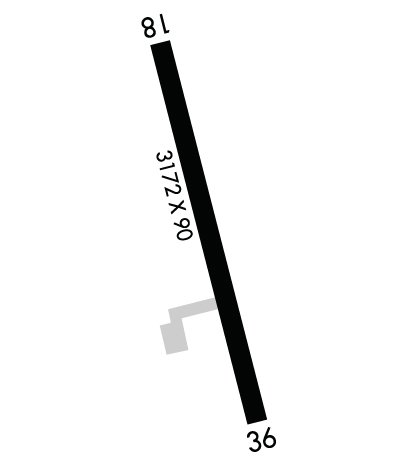
| Lat: N 4206.4 Long: W 07130.6 Elev: 269 Var: +16 Longest Runway: 3172 | ||
| CTAF: 122.8 | ||
| ||||||||||||||||||||||||||||||||
| ||||||||||||||||||||||||||||||||
| Rwy | Rwy | |||||||
| 3172x90 | 3172' | 3172x90 | 3062' | |||||
| Runway ID | Single Wheel | Double Wheel | Double Tandem Wheel | Dual Double Wheel |
| 18/36 | 12,000 | N/A | N/A | N/A |
| These numbers are Advisory and are not limits. The Airport Manager should have more accurate Weight Limits | ||||
 Airport Diagram might not be current. | |
| Facility Name: | HOPEDALE INDUSTRIAL PARK |
| City Name: | HOPEDALE |
| County: | WORCESTER |
| State abbrev: | MA |
| State Name: | MASSACHUSETTS |
| Ownership: | PRIVATELY OWNED |
| Use: | OPEN TO THE PUBLIC |
| Owner's Name: | HOPEDALE ARPT INDUSTRIAL PARK |
| Address: | 1 AIRPORT DRIVE |
| HOPEDALE, MA 01747 | |
| Owner's Phone: | 508-478-1726 |
| Manager's Name: | JOSEPH MENFI |
| Address: | HOPEDALE INDUSTRIAL PARK |
| HOPEDALE, MA 01747 | |
| Phone: | 508-478-1726 |
| FAA Region: | NEW ENGLAND |
| FAA Field Office: | NONE |
| Date | Sunrise | Sunset |
|---|---|---|
| 07/04/26 Saturday | 5:15 | 20:25 |
| 07/05/26 Sunday | 5:16 | 20:25 |
| 07/06/26 Monday | 5:17 | 20:25 |
| 07/07/26 Tuesday | 5:17 | 20:24 |
| 07/08/26 Wednesday | 5:18 | 20:24 |
| 07/09/26 Thursday | 5:19 | 20:24 |
| 07/10/26 Friday | 5:19 | 20:23 |
| 07/11/26 Saturday | 5:20 | 20:23 |
| 07/12/26 Sunday | 5:21 | 20:22 |
| 07/13/26 Monday | 5:22 | 20:22 |
| 07/14/26 Tuesday | 5:22 | 20:21 |
| 07/15/26 Wednesday | 5:23 | 20:20 |
| 07/16/26 Thursday | 5:24 | 20:20 |
| 07/17/26 Friday | 5:25 | 20:19 |
| Airport Attendance Schedule | MON-FRI DAWN-DUSK |
| Airport Status | OPERATIONAL (This Status can change at any time - please check NOTAMS) |
| Airport Lighting Schedule | DUSK-2200. |
| Airport Storage Available | Tie Downs |
| Extra Services Available | NONE |
| Wind Indicator | YES - (unlit) |
| Control Tower | NO |
| CTAF Frequency | 122.800 |
| Unicom Frequency | 122.800 |
| Rotating Beacon Color | |
| Segmented Circle | NO |
| Landing Fee | NO |
| Airport Inspected | STATE - performed by STATE AERONAUTICAL PERSONNEL |
| Inspection Date | 10/30/2025 |
| Type of Fuel Available | None |
| Airframe Repair Service | NONE |
| Power Plant Repair Service | NONE |
| Latitude | N4206.4 |
| Longitude | W07130.6 (ESTIMATED) |
| Arpt Elevation | 269ft (ESTIMATED) |
| Magnetic Variation | 16W |
| 3 miles SE | of HOPEDALE |
| Traffic Pattern Altitude | |
| Sectional Chart | NEW YORK |
| Operations (Reported) | Yearly | Avg. Daily |
|---|---|---|
| General Aviation Transient | 0 | 0 |
| General Aviation Local | 0 | 0 |
| Air Taxi | 0 | 0 |
| Commerical | 0 | 0 |
| Commuter | 0 | 0 |
| Military | 0 | 0 |
| Aircraft based on Field | |
|---|---|
| General Aviation Singles | 0 |
| General Aviation Multi | 0 |
| Jet Aircraft | 0 |
| General Aviation Helicopters | 0 |
| Military Aircraft | 0 |
| Gliders | 0 |
| Ultralights | 0 |
| FSS on field | NO |
| FSS tie-in | BRIDGEPORT |
| FSS Phone | 1-800-WX-BRIEF |
| Who issues Notams | BDR |
| Notam D service at airport | YES |
| ARTCC Name | BOSTON |
| Airport Certification | |
| Aircraft Rescue & Firefighting Index | None |
| Airport of Entry | No |
| Custom Landing Rights | No |
| Joint Civil/Military | No |
| Military Landing rights | No |
| THIS AIRPORT HAS BEEN SURVEYED BY THE NATIONAL GEODETIC SURVEY. |
| ARPT CLSD TO TSNT ACFT SS-SR. |
| RWY 18, TWO STORY HOUSE 27 FT AGL (291 FT MSL) LCTD APRXLY 400 FT NW RWY THR. |
| ARPT CLSD TO TSNT STUDENT TRNG. |
| ARPT CLSD TO JETS & NIGHT LDGS EXC PPR CALL 508-478-1726. |
| WILDLIFE INVOF ARPT. |
| FOR CD CTC BRADLEY APCH AT 860-386-3597. |
Airport Communications & Frequencies:
|
| Runway: 18 | Runway: 36 | ||
| Mag heading: | 182° | Mag heading: | 2° |
| Rwy Slope: | -.98% Down | Rwy Slope: | .98% Up |
| Approach: | Approach: | ||
| Pattern: | Left Traffic | Pattern: | Left Traffic |
| Markings: | BASIC | Markings: | BASIC |
| Marking Condition: | FAIR | Marking Condition: | FAIR |
| Arresting Dev: | Arresting Dev: | ||
| Lat & Long: | N4206.6 W07130.7 | Lat. & Long.: | N4206.1 W07130.5 |
| Elev: | 268.0 ft. MSL | Elev: | 237.0 ft. MSL |
| TCH: | TCH: | ||
| Visual Glide Path: | Visual Glide Path: | ||
| Displaced Threshold: | No | Displaced Threshold: | 110 feet; APCH RATIO 3:1 AT DTHR. |
| Touchdown Zone: | NO | Touchdown Zone: | NO |
| Touchdown Elev.: | Touchdown Elev.: | ||
| Visual Glide Slope: | Visual Glide Slope: | ||
| RVR Equipment: | RVR Equipment: | ||
| RVV Equipment: | NO | RVV Equipment: | NO |
| Approach Lights: | Approach Lights: | ||
| REIL: | NO | REIL: | NO |
| Centerline Lights: | NO | Centerline Lights: | NO |
| Touchdown lights: | NO | Touchdown lights: | NO |
| Runway Category: | Runway with a Visual Approach | Runway Category: | Runway with a Non-precision Approach |
| Declared Distances: | Declared Distances: | ||
| Obstructions: | TREES | Obstructions: | TREES |
| Marked: | NOT Marked/Lighted | Marked: | NOT Marked/Lighted |
| Clearance slope: | 4:1 | Clearance slope: | 2:1 |
| Obstruction height: | 60 feet AGL | Obstruction height: | 60 feet AGL |
| Dist. from runway: | 470 feet | Dist. from runway: | 325 feet |
| Centerline offset: | 63B | Centerline offset: | 100 feet left of centerline |
| Comments: | ROAD 30 FT N FM RWY END. | Comments: | ROAD 20 FT FM RWY END. |
Thanks for using FltPlan.com
all rights reserved © 1999-2026 by Flight Plan LLC
