| FLORALA MUNI FLORALA AL |
| |
| Lat: N 3102.5 Long: W 08618.7 Elev: 314 Var: +02 Longest Runway: 3197 | ||
| CTAF: 123.0 | ||
| |||||||||||||||||||||||
| |||||||||||||||||||||||
| Rwy | Rwy | |||||||
| 3197x75 | 3197' | 3197x75 | 3197' | |||||
| Runway ID | Single Wheel | Double Wheel | Double Tandem Wheel | Dual Double Wheel |
| 04/22 | N/A | N/A | N/A | N/A |
| These numbers are Advisory and are not limits. The Airport Manager should have more accurate Weight Limits | ||||
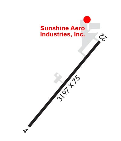 Airport Diagram might not be current. | |
| Facility Name: | FLORALA MUNI |
| City Name: | FLORALA |
| County: | COVINGTON |
| State abbrev: | AL |
| State Name: | ALABAMA |
| Ownership: | PUBLICLY OWNED |
| Use: | OPEN TO THE PUBLIC |
| Owner's Name: | CITY OF FLORALA |
| Address: | PO BOX 351 |
| FLORALA, AL 36442 | |
| Owner's Phone: | 334-858-3612 |
| Manager's Name: | FLORALA AIRPORT AUTHORITY; RICKY SUGGS, CHAIRMAN. |
| Address: | P.O. BOX 76 |
| FLORALA, AL 36442 | |
| Phone: | 334-488-3679 |
| FAA Region: | SOUTHERN |
| FAA Field Office: | JAN |
| Date | Sunrise | Sunset |
|---|---|---|
| 09/24/21 Friday | 6:35 | 18:40 |
| 09/25/21 Saturday | 6:35 | 18:38 |
| 09/26/21 Sunday | 6:36 | 18:37 |
| 09/27/21 Monday | 6:36 | 18:36 |
| 09/28/21 Tuesday | 6:37 | 18:34 |
| 09/29/21 Wednesday | 6:38 | 18:33 |
| 09/30/21 Thursday | 6:38 | 18:32 |
| 10/01/21 Friday | 6:39 | 18:31 |
| 10/02/21 Saturday | 6:39 | 18:29 |
| 10/03/21 Sunday | 6:40 | 18:28 |
| 10/04/21 Monday | 6:41 | 18:27 |
| 10/05/21 Tuesday | 6:41 | 18:26 |
| 10/06/21 Wednesday | 6:42 | 18:24 |
| 10/07/21 Thursday | 6:42 | 18:23 |
| Airport Attendance Schedule | 7 Days A Week 0800-2400 |
| Airport Status | OPERATIONAL (This Status can change at any time - please check NOTAMS) |
| Airport Lighting Schedule | SS-SR |
| Airport Storage Available | Tie Downs |
| Extra Services Available | NONE |
| Wind Indicator | YES - (lighted) |
| Control Tower | NO |
| CTAF Frequency | 123.000 |
| Unicom Frequency | 123.000 |
| Rotating Beacon Color | CLEAR-GREEN (Light Land Airport) |
| Segmented Circle | YES |
| Landing Fee | NO |
| Airport Inspected | STATE - performed by STATE AERONAUTICAL PERSONNEL |
| Inspection Date | 09/28/2020 |
| Type of Fuel Available | Grade 100LL, JET A (freeze point -40C) |
| Airframe Repair Service | MAJOR |
| Power Plant Repair Service | MAJOR |
| Latitude | N3102.5 |
| Longitude | W08618.7 (ESTIMATED) |
| Arpt Elevation | 314ft (SURVEYED) |
| Magnetic Variation | 02W |
| 3 miles NE | of FLORALA |
| Traffic Pattern Altitude | |
| Sectional Chart | NEW ORLEANS |
| Operations (Reported) | Yearly | Avg. Daily |
|---|---|---|
| General Aviation Transient | 1220 | 3 |
| General Aviation Local | 720 | 2 |
| Air Taxi | 0 | 0 |
| Commerical | 0 | 0 |
| Commuter | 0 | 0 |
| Military | 20000 | 55 |
| Aircraft based on Field | |
|---|---|
| General Aviation Singles | 11 |
| General Aviation Multi | 0 |
| Jet Aircraft | 0 |
| General Aviation Helicopters | 0 |
| Military Aircraft | 0 |
| Gliders | 0 |
| Ultralights | 0 |
| FSS on field | NO |
| FSS tie-in | ANNISTON |
| FSS Phone | 1-800-WX-BRIEF |
| Who issues Notams | ANB |
| Notam D service at airport | YES |
| ARTCC Name | JACKSONVILLE |
| Airport Certification | |
| Aircraft Rescue & Firefighting Index | None |
| Airport of Entry | No |
| Custom Landing Rights | No |
| Joint Civil/Military | No |
| Military Landing rights | No |
| NATIONAL PLAN OF INTEGRATED AIRPORT SYSTEMS (NPIAS) |
| NO RUNNING LNDGS ON RY/TWY BY SKID EQPTD HEL. |
| DEER ON & INVOF RWY. |
| (E81) TWY LGTS AT APN TURN-OFF ONLY. |
| ROTORCRAFT AND HEL AVOID ACFT PAINT HNGR IN MID OF FLD. |
| FOR CD CTC CAIRNS APCH AT 334-255-8402, WHEN APCH CLSD CTC JACKSONVILLE ARTCC AT 904-845-1592. |
Airport Communications & Frequencies:
| ||||||||||||||
| Runway: 04 | Runway: 22 | ||
| Mag heading: | 40° | Mag heading: | 220° |
| Rwy Slope: | .83% Up | Rwy Slope: | -.83% Down |
| Approach: | Approach: | ||
| Pattern: | Left Traffic | Pattern: | Left Traffic |
| Markings: | BASIC | Markings: | BASIC |
| Marking Condition: | GOOD | Marking Condition: | GOOD |
| Arresting Dev: | Arresting Dev: | ||
| Lat & Long: | N3102.3 W08618.9 | Lat. & Long.: | N3102.8 W08618.5 |
| Elev: | 287.7 ft. MSL | Elev: | 314.3 ft. MSL |
| TCH: | TCH: | ||
| Visual Glide Path: | Visual Glide Path: | ||
| Displaced Threshold: | No | Displaced Threshold: | No |
| Touchdown Zone: | YES | Touchdown Zone: | YES |
| Touchdown Elev.: | 311.6 feet | Touchdown Elev.: | 314.3 feet |
| Visual Glide Slope: | Visual Glide Slope: | ||
| RVR Equipment: | RVR Equipment: | ||
| RVV Equipment: | NO | RVV Equipment: | NO |
| Approach Lights: | Approach Lights: | ||
| REIL: | NO | REIL: | NO |
| Centerline Lights: | NO | Centerline Lights: | NO |
| Touchdown lights: | NO | Touchdown lights: | NO |
| Runway Category: | Runway with a Non-precision Approach | Runway Category: | Runway with a Visual Approach |
| Declared Distances: | Declared Distances: | ||
| Obstructions: | TREES | Obstructions: | TREES |
| Marked: | NOT Marked/Lighted | Marked: | NOT Marked/Lighted |
| Clearance slope: | 21:1 | Clearance slope: | 17:1 |
| Obstruction height: | 49 feet AGL | Obstruction height: | 66 feet AGL |
| Dist. from runway: | 1245 feet | Dist. from runway: | 1342 feet |
| Centerline offset: | 183 left of centerline | Centerline offset: | 345 feet right of centerline |
| Comments: | Comments: |
Thanks for using FltPlan.com
all rights reserved © 1999-2021 by Flight Plan LLC