
| GLADEWATER MUNI GLADEWATER TX |
| |
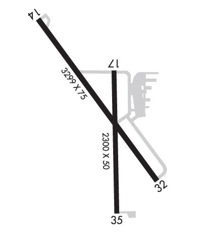
| Lat: N 3231.7 Long: W 09458.3 Elev: 297 Var: -03 Longest Runway: 3299 | ||
| CTAF: 122.9 | ||
| ||||||
|
| Rwy | Rwy | |||||||
| 3299x75 | 3299' | 3299x75 | 3299' | |||||
| 2300x50 | 2300' | 2300x50 | 2300' | |||||
| Runway ID | Single Wheel | Double Wheel | Double Tandem Wheel | Dual Double Wheel |
| 14/32 | 12,500 | N/A | N/A | N/A |
| 17/35 | 7,000 | N/A | N/A | N/A |
| These numbers are Advisory and are not limits. The Airport Manager should have more accurate Weight Limits | ||||
 Airport Diagram might not be current. | |
| Facility Name: | GLADEWATER MUNI |
| City Name: | GLADEWATER |
| County: | GREGG |
| State abbrev: | TX |
| State Name: | TEXAS |
| Ownership: | PUBLICLY OWNED |
| Use: | OPEN TO THE PUBLIC |
| Owner's Name: | CITY OF GLADEWATER |
| Address: | 519 E BROADWAY AVE, PO BOX 1725 |
| GLADEWATER, TX 75647 | |
| Owner's Phone: | 903-845-2196 |
| Manager's Name: | CHARLIE SMITH |
| Address: | 519 E BROADWAY AVE, PO BOX 1725 |
| GLADEWATER, TX 75647 | |
| Phone: | 903-845-2586 |
| FAA Region: | SOUTHWEST |
| FAA Field Office: | TEX |
| Date | Sunrise | Sunset |
|---|---|---|
| 06/07/26 Sunday | 6:12 | 20:25 |
| 06/08/26 Monday | 6:12 | 20:26 |
| 06/09/26 Tuesday | 6:12 | 20:26 |
| 06/10/26 Wednesday | 6:12 | 20:27 |
| 06/11/26 Thursday | 6:12 | 20:27 |
| 06/12/26 Friday | 6:12 | 20:28 |
| 06/13/26 Saturday | 6:12 | 20:28 |
| 06/14/26 Sunday | 6:12 | 20:28 |
| 06/15/26 Monday | 6:12 | 20:29 |
| 06/16/26 Tuesday | 6:12 | 20:29 |
| 06/17/26 Wednesday | 6:12 | 20:29 |
| 06/18/26 Thursday | 6:12 | 20:30 |
| 06/19/26 Friday | 6:12 | 20:30 |
| 06/20/26 Saturday | 6:13 | 20:30 |
| Airport Attendance Schedule | 7 Days A Week 0800-1700; FOR SVC AFT HRS CALL 903-235-0784. |
| Airport Status | OPERATIONAL (This Status can change at any time - please check NOTAMS) |
| Airport Lighting Schedule | SS-SR |
| Airport Storage Available | Tie Downs |
| Extra Services Available | Flight Instruction, Parachute Jumping, Aircraft Rental |
| Wind Indicator | YES - (lighted) |
| Control Tower | NO |
| CTAF Frequency | 122.900 |
| Unicom Frequency | |
| Rotating Beacon Color | WG |
| Segmented Circle | NO |
| Landing Fee | NO |
| Airport Inspected | STATE - performed by PRIVATE CONTRACT PERSONNEL |
| Inspection Date | 05/10/2025 |
| Type of Fuel Available | Grade 100LL |
| Airframe Repair Service | NONE |
| Power Plant Repair Service | NONE |
| Latitude | N3231.7 |
| Longitude | W09458.3 (ESTIMATED) |
| Arpt Elevation | 296ft (SURVEYED) |
| Magnetic Variation | 03E |
| 2 miles SW | of GLADEWATER |
| Traffic Pattern Altitude | |
| Sectional Chart | MEMPHIS |
| Operations (Reported) | Yearly | Avg. Daily |
|---|---|---|
| General Aviation Transient | 0 | 0 |
| General Aviation Local | 0 | 0 |
| Air Taxi | 0 | 0 |
| Commerical | 0 | 0 |
| Commuter | 0 | 0 |
| Military | 0 | 0 |
| Aircraft based on Field | |
|---|---|
| General Aviation Singles | 0 |
| General Aviation Multi | 0 |
| Jet Aircraft | 0 |
| General Aviation Helicopters | 0 |
| Military Aircraft | 0 |
| Gliders | 0 |
| Ultralights | 0 |
| FSS on field | NO |
| FSS tie-in | FORT WORTH |
| FSS Phone | 1-800-WX-BRIEF |
| Who issues Notams | FTW |
| Notam D service at airport | YES |
| ARTCC Name | FORT WORTH |
| Airport Certification | |
| Aircraft Rescue & Firefighting Index | None |
| Airport of Entry | No |
| Custom Landing Rights | No |
| Joint Civil/Military | No |
| Military Landing rights | YES |
| NATIONAL PLAN OF INTEGRATED AIRPORT SYSTEMS (NPIAS) |
| GRANT AGREEMENTS UNDER FAAP/ADAP/AIP |
| ASSURANCES PURSUANT TO TITLE VI, CIVIL RIGHTS ACT OF 1964 |
| FOR CD CTC FORT WORTH ARTCC AT 817-858-7584. |
| ARPT PHYS ADDR 1300 US-271, GLADEWATER, TX |
| RWY 17/3 5 NMRS CRACKS, LOOSE STONES. |
Airport Communications & Frequencies:
| |||||||||||||||
| Runway: 14 | Runway: 32 | ||
| Mag heading: | 140° | Mag heading: | 320° |
| Rwy Slope: | .32% Up | Rwy Slope: | -.32% Down |
| Approach: | Approach: | ||
| Pattern: | Left Traffic | Pattern: | Left Traffic |
| Markings: | NONPRECISION INSTRUMENT | Markings: | NONPRECISION INSTRUMENT |
| Marking Condition: | GOOD | Marking Condition: | GOOD |
| Arresting Dev: | Arresting Dev: | ||
| Lat & Long: | N3232.0 W09458.5 | Lat. & Long.: | N3231.6 W09458.1 |
| Elev: | 285.0 ft. MSL | Elev: | 295.6 ft. MSL |
| TCH: | 44 ft. AGL | TCH: | |
| Visual Glide Path: | 3.00 degrees | Visual Glide Path: | |
| Displaced Threshold: | No | Displaced Threshold: | No |
| Touchdown Zone: | YES | Touchdown Zone: | YES |
| Touchdown Elev.: | 296.5 feet | Touchdown Elev.: | 296.5 feet |
| Visual Glide Slope: | 2-Light PAPI on LEFT side of Runway | Visual Glide Slope: | |
| RVR Equipment: | RVR Equipment: | ||
| RVV Equipment: | NO | RVV Equipment: | NO |
| Approach Lights: | Approach Lights: | ||
| REIL: | NO | REIL: | NO |
| Centerline Lights: | NO | Centerline Lights: | NO |
| Touchdown lights: | NO | Touchdown lights: | NO |
| Runway Category: | Runway with a Non-precision Approach | Runway Category: | Runway with a Non-precision Approach |
| Declared Distances: | Declared Distances: | ||
| Obstructions: | TREES | Obstructions: | TREES |
| Marked: | NOT Marked/Lighted | Marked: | NOT Marked/Lighted |
| Clearance slope: | CONTROLLING OBSTRUCTION EXCEEDS A 45 DEGREE SLOPE | Clearance slope: | 10:1 |
| Obstruction height: | 25 feet AGL | Obstruction height: | 85 feet AGL |
| Dist. from runway: | 201 feet | Dist. from runway: | 1050 feet |
| Centerline offset: | 130 right of centerline | Centerline offset: | 415 feet right of centerline |
| Comments: | 15 FT TREES, 0-199 FT DSTC, 84 FT R. | Comments: | 12 FT TREES, 50 FT DSTC, 130 FT L. |
| Runway: 17 | Runway: 35 | ||
| Mag heading: | 176° | Mag heading: | 356° |
| Rwy Slope: | .12% Up | Rwy Slope: | -.12% Down |
| Approach: | Approach: | ||
| Pattern: | Left Traffic | Pattern: | Left Traffic |
| Markings: | BASIC | Markings: | BASIC |
| Marking Condition: | GOOD | Marking Condition: | GOOD |
| Arresting Dev: | Arresting Dev: | ||
| Lat & Long: | N3231.9 W09458.3 | Lat. & Long.: | N3231.5 W09458.3 |
| Elev: | 291.9 ft. MSL | Elev: | 294.6 ft. MSL |
| TCH: | TCH: | ||
| Visual Glide Path: | Visual Glide Path: | ||
| Displaced Threshold: | No | Displaced Threshold: | No |
| Touchdown Zone: | YES | Touchdown Zone: | YES |
| Touchdown Elev.: | 296.4 feet | Touchdown Elev.: | 296.4 feet |
| Visual Glide Slope: | Visual Glide Slope: | ||
| RVR Equipment: | RVR Equipment: | ||
| RVV Equipment: | NO | RVV Equipment: | NO |
| Approach Lights: | Approach Lights: | ||
| REIL: | NO | REIL: | NO |
| Centerline Lights: | NO | Centerline Lights: | NO |
| Touchdown lights: | NO | Touchdown lights: | NO |
| Runway Category: | Runway with a Visual Approach | Runway Category: | Runway with a Visual Approach |
| Declared Distances: | Declared Distances: | ||
| Obstructions: | TREES | Obstructions: | TREES |
| Marked: | NOT Marked/Lighted | Marked: | NOT Marked/Lighted |
| Clearance slope: | 1:1 | Clearance slope: | 4:1 |
| Obstruction height: | 45 feet AGL | Obstruction height: | 40 feet AGL |
| Dist. from runway: | 268 feet | Dist. from runway: | 375 feet |
| Centerline offset: | 125 left of centerline | Centerline offset: | 55 feet left of centerline |
| Comments: | Comments: |
Thanks for using FltPlan.com
all rights reserved © 1999-2026 by Flight Plan LLC
