
| ROLLA DOWNTOWN ROLLA MO |
| |
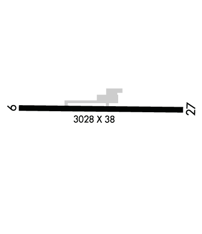
| Lat: N 3756.1 Long: W 09148.8 Elev: 987 Var: -05 Longest Runway: 3028 | ||
| CTAF: 122.8 | ||
| ||||||||||||||||||||||||||||||||
| ||||||||||||||||||||||||||||||||
| Rwy | Rwy | |||||||
| 3028x38 | 3028' | 3028x38 | 2583' | |||||
| Runway ID | Single Wheel | Double Wheel | Double Tandem Wheel | Dual Double Wheel |
| 09/27 | N/A | N/A | N/A | N/A |
| These numbers are Advisory and are not limits. The Airport Manager should have more accurate Weight Limits | ||||
| FltPlan does not have IFR approach charts available for KK07. |
 Airport Diagram might not be current. | |
| Facility Name: | ROLLA DOWNTOWN |
| City Name: | ROLLA |
| County: | PHELPS |
| State abbrev: | MO |
| State Name: | MISSOURI |
| Ownership: | PRIVATELY OWNED |
| Use: | OPEN TO THE PUBLIC |
| Owner's Name: | MAXINE DICKMAN FOSMARK |
| Address: | 13720 COUNTY ROAD 7040 |
| ROLLA, MO 65401 | |
| Owner's Phone: | 573-341-2994 |
| Manager's Name: | MAXINE DICKMAN |
| Address: | 13720 COUNTY ROAD 7040 |
| ROLLA, MO 65401 | |
| Phone: | 573-341-2994 |
| FAA Region: | CENTRAL |
| FAA Field Office: | NONE |
| Date | Sunrise | Sunset |
|---|---|---|
| 09/24/21 Friday | 6:57 | 19:01 |
| 09/25/21 Saturday | 6:57 | 19:00 |
| 09/26/21 Sunday | 6:58 | 18:58 |
| 09/27/21 Monday | 6:59 | 18:57 |
| 09/28/21 Tuesday | 7:00 | 18:55 |
| 09/29/21 Wednesday | 7:01 | 18:54 |
| 09/30/21 Thursday | 7:02 | 18:52 |
| 10/01/21 Friday | 7:03 | 18:51 |
| 10/02/21 Saturday | 7:04 | 18:49 |
| 10/03/21 Sunday | 7:04 | 18:48 |
| 10/04/21 Monday | 7:05 | 18:46 |
| 10/05/21 Tuesday | 7:06 | 18:45 |
| 10/06/21 Wednesday | 7:07 | 18:43 |
| 10/07/21 Thursday | 7:08 | 18:42 |
| Airport Attendance Schedule | UNATTENDED |
| Airport Status | OPERATIONAL (This Status can change at any time - please check NOTAMS) |
| Airport Lighting Schedule | |
| Airport Storage Available | Tie Downs |
| Extra Services Available | NONE |
| Wind Indicator | YES - (unlit) |
| Control Tower | NO |
| CTAF Frequency | 122.800 |
| Unicom Frequency | 122.800; UNICOM UNMON. |
| Rotating Beacon Color | |
| Segmented Circle | NO |
| Landing Fee | NO |
| Airport Inspected | STATE - performed by STATE AERONAUTICAL PERSONNEL |
| Inspection Date | 05/07/2018 |
| Type of Fuel Available | None |
| Airframe Repair Service | None |
| Power Plant Repair Service | None |
| Latitude | N3756.1 |
| Longitude | W09148.8 (ESTIMATED) |
| Arpt Elevation | 987ft (SURVEYED) |
| Magnetic Variation | 05E |
| 3 miles SW | of ROLLA |
| Traffic Pattern Altitude | |
| Sectional Chart | KANSAS CITY |
| Operations (Reported) | Yearly | Avg. Daily |
|---|---|---|
| General Aviation Transient | 15 | 0 |
| General Aviation Local | 300 | 1 |
| Air Taxi | 0 | 0 |
| Commerical | 0 | 0 |
| Commuter | 0 | 0 |
| Military | 0 | 0 |
| Aircraft based on Field | |
|---|---|
| General Aviation Singles | 3 |
| General Aviation Multi | 0 |
| Jet Aircraft | 0 |
| General Aviation Helicopters | 0 |
| Military Aircraft | 0 |
| Gliders | 0 |
| Ultralights | 0 |
| FSS on field | NO |
| FSS tie-in | COLUMBIA |
| FSS Phone | 1-800-WX-BRIEF |
| Who issues Notams | COU |
| Notam D service at airport | YES |
| ARTCC Name | KANSAS CITY |
| Airport Certification | |
| Aircraft Rescue & Firefighting Index | None |
| Airport of Entry | No |
| Custom Landing Rights | No |
| Joint Civil/Military | No |
| Military Landing rights | YES |
| THIS AIRPORT HAS BEEN SURVEYED BY THE NATIONAL GEODETIC SURVEY. |
| WILDLIFE ON & INVOF ARPT. |
| RY 09/27 LINE OF SIGHT OBSTRUCTED BY GRADE CHANGE IN RY. |
| TALL BRUSH LOCATED 70-125 FT SOUTH OF RY, FM RY 09 THLD TO ACCESS TWY. |
| FOR CD CTC KANSAS CITY ARTCC AT 913-254-8508. |
| RWY 09/2 7 RWY 9/27 PAVEMENT CRACKING, VEGETATION GROWING IN CRACKS. |
| RWY 09 1 RWY 09 NSTD BSC MARKINGS: INCORRECT SPACING OF DESIGNATION MARKINGS RY 09. |
| RWY 27 1 NSTD BSC MARKNGS; INCORRECT LENGTH; WIDTH; COLOR & SPACING OF DSPLCD THLD & DESIGNATION MARKINGS RY 27. |
Airport Communications & Frequencies:
| |||||||||
| Runway: 09 | Runway: 27 | ||
| Mag heading: | 88° | Mag heading: | 268° |
| Rwy Slope: | .26% Up | Rwy Slope: | -.26% Down |
| Approach: | Approach: | ||
| Pattern: | Left Traffic | Pattern: | Left Traffic |
| Markings: | NONSTANDARD | Markings: | NONSTANDARD |
| Marking Condition: | FAIR; MARKINGS FADED. | Marking Condition: | FAIR; MARKINGS FADED. |
| Arresting Dev: | Arresting Dev: | ||
| Lat & Long: | N3756.2 W09149.1 | Lat. & Long.: | N3756.1 W09148.5 |
| Elev: | 956.0 ft. MSL | Elev: | 964.0 ft. MSL |
| TCH: | TCH: | ||
| Visual Glide Path: | Visual Glide Path: | ||
| Displaced Threshold: | No | Displaced Threshold: | 445 feet |
| Touchdown Zone: | YES | Touchdown Zone: | YES |
| Touchdown Elev.: | 956.0 feet | Touchdown Elev.: | 964.0 feet |
| Visual Glide Slope: | Visual Glide Slope: | ||
| RVR Equipment: | RVR Equipment: | ||
| RVV Equipment: | NO | RVV Equipment: | NO |
| Approach Lights: | Approach Lights: | ||
| REIL: | NO | REIL: | NO |
| Centerline Lights: | NO | Centerline Lights: | NO |
| Touchdown lights: | NO | Touchdown lights: | NO |
| Runway Category: | Runway with a Visual Approach | Runway Category: | Runway with a Visual Approach |
| Declared Distances: | Declared Distances: | ||
| Obstructions: | TREES | Obstructions: | TREES |
| Marked: | NOT Marked/Lighted | Marked: | NOT Marked/Lighted |
| Clearance slope: | 16:1 | Clearance slope: | RY 27 9:1TO DSPLCD THLD; +30 FT TREE, 340 FT FM DSPLCD THLD, 50 FT R. |
| Obstruction height: | 25 feet AGL | Obstruction height: | 55 feet AGL |
| Dist. from runway: | 600 feet | Dist. from runway: | 200 feet |
| Centerline offset: | 117 right of centerline | Centerline offset: | 125 feet right of centerline |
| Comments: | RWY 09 20-25 FT TREES, BRUSH 0-30 FT FM RWY END, 70 FT RIGHT. | Comments: | RWY 27 1-55 FT TREES; FENCES; POWERLINES; BRUSHES & HIGH GND 0-200 FT FM RWY END LEFT & RIGHT. |
Thanks for using FltPlan.com
all rights reserved © 1999-2021 by Flight Plan LLC
