
| RANDALL MIDDLETOWN NY |
| |
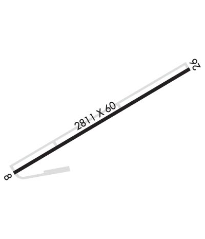
| Lat: N 4125.9 Long: W 07423.5 Elev: 523 Var: +13 Longest Runway: 2810 | ||
| CTAF: 122.8 | ||
| ||||||||||||||||||||||||||||||||
| ||||||||||||||||||||||||||||||||
| Rwy | Rwy | |||||||
| 2810x60 | 2247' | 2810x60 | 2810' | |||||
| Runway ID | Single Wheel | Double Wheel | Double Tandem Wheel | Dual Double Wheel |
| 08/26 | 25,000 | N/A | N/A | N/A |
| These numbers are Advisory and are not limits. The Airport Manager should have more accurate Weight Limits | ||||
 Airport Diagram might not be current. | |
| Facility Name: | RANDALL |
| City Name: | MIDDLETOWN |
| County: | ORANGE |
| State abbrev: | NY |
| State Name: | NEW YORK |
| Ownership: | PRIVATELY OWNED |
| Use: | OPEN TO THE PUBLIC |
| Owner's Name: | AERODROME DEV CORP |
| Address: | PO BOX 3062, 100 AIRPORT RD |
| MIDDLETOWN, NY 10940 | |
| Owner's Phone: | 845-343-5965 |
| Manager's Name: | CHARLES BRODIE |
| Address: | P O BOX 3062, 100 AIRPORT RD |
| MIDDLETOWN, NY 10940 | |
| Phone: | 845-343-5965 |
| FAA Region: | EASTERN |
| FAA Field Office: | NYC |

| Date | Sunrise | Sunset |
|---|---|---|
| 09/24/21 Friday | 6:47 | 18:52 |
| 09/25/21 Saturday | 6:48 | 18:50 |
| 09/26/21 Sunday | 6:49 | 18:48 |
| 09/27/21 Monday | 6:50 | 18:47 |
| 09/28/21 Tuesday | 6:51 | 18:45 |
| 09/29/21 Wednesday | 6:52 | 18:43 |
| 09/30/21 Thursday | 6:53 | 18:42 |
| 10/01/21 Friday | 6:54 | 18:40 |
| 10/02/21 Saturday | 6:55 | 18:38 |
| 10/03/21 Sunday | 6:56 | 18:36 |
| 10/04/21 Monday | 6:57 | 18:35 |
| 10/05/21 Tuesday | 6:58 | 18:33 |
| 10/06/21 Wednesday | 6:59 | 18:31 |
| 10/07/21 Thursday | 7:00 | 18:30 |
| Airport Attendance Schedule | UNATTENDED |
| Airport Status | OPERATIONAL (This Status can change at any time - please check NOTAMS) |
| Airport Lighting Schedule | ACTVT MIRL RWY 08/26 - CTAF. |
| Airport Storage Available | Tie Downs |
| Extra Services Available | Glider, Glider Towing |
| Wind Indicator | YES - (unlit) |
| Control Tower | NO |
| CTAF Frequency | 122.800 |
| Unicom Frequency | 122.800 |
| Rotating Beacon Color | |
| Segmented Circle | NO |
| Landing Fee | NO |
| Airport Inspected | STATE - performed by STATE AERONAUTICAL PERSONNEL |
| Inspection Date | 05/24/2018 |
| Type of Fuel Available | None |
| Airframe Repair Service | NONE |
| Power Plant Repair Service | NONE |
| Latitude | N4125.9 |
| Longitude | W07423.5 (ESTIMATED) |
| Arpt Elevation | 522ft (SURVEYED) |
| Magnetic Variation | 13W |
| 2 miles SE | of MIDDLETOWN |
| Traffic Pattern Altitude | |
| Sectional Chart | NEW YORK |
| Operations (Reported) | Yearly | Avg. Daily |
|---|---|---|
| General Aviation Transient | 5500 | 15 |
| General Aviation Local | 17000 | 47 |
| Air Taxi | 0 | 0 |
| Commerical | 0 | 0 |
| Commuter | 0 | 0 |
| Military | 0 | 0 |
| Aircraft based on Field | |
|---|---|
| General Aviation Singles | 12 |
| General Aviation Multi | 0 |
| Jet Aircraft | 0 |
| General Aviation Helicopters | 0 |
| Military Aircraft | 0 |
| Gliders | 20 |
| Ultralights | 0 |
| FSS on field | NO |
| FSS tie-in | NEW YORK |
| FSS Phone | 1-800-WX-BRIEF |
| Who issues Notams | ISP |
| Notam D service at airport | YES |
| ARTCC Name | NEW YORK |
| Airport Certification | |
| Aircraft Rescue & Firefighting Index | None |
| Airport of Entry | No |
| Custom Landing Rights | No |
| Joint Civil/Military | No |
| Military Landing rights | No |
| NATIONAL PLAN OF INTEGRATED AIRPORT SYSTEMS (NPIAS) |
| GRANT AGREEMENTS UNDER FAAP/ADAP/AIP |
| ASSURANCES PURSUANT TO TITLE VI, CIVIL RIGHTS ACT OF 1964 |
| HVY GLIDER & HANG GLIDER ACT ON WKENDS & HOLS. |
| ULTRA-LIGHT ON AND INVOF ARPT. |
| FOR CD CTC NEW YORK APCH AT 516-683-2448 |
| RWY 08/2 6 SW STRENGTH IS 12.5 |
| RWY 08/2 6 SEVERAL RWY AND TWY LGTS OTS INDEFLY. |
Airport Communications & Frequencies:
| ||||||||||||||
| Runway: 08 | Runway: 26 | ||
| Mag heading: | 75° | Mag heading: | 255° |
| Rwy Slope: | .63% Up | Rwy Slope: | -.63% Down |
| Approach: | Approach: | ||
| Pattern: | Left Traffic | Pattern: | Left Traffic |
| Markings: | NONPRECISION INSTRUMENT | Markings: | NONPRECISION INSTRUMENT |
| Marking Condition: | POOR; RUNWAY MARKINGS VERY BADLY FADED | Marking Condition: | POOR |
| Arresting Dev: | Arresting Dev: | ||
| Lat & Long: | N4125.8 W07423.8 | Lat. & Long.: | N4126.0 W07423.2 |
| Elev: | 503.0 ft. MSL | Elev: | 520.7 ft. MSL |
| TCH: | 44 ft. AGL | TCH: | 30 ft. AGL |
| Visual Glide Path: | 4.00 degrees | Visual Glide Path: | 4.00 degrees |
| Displaced Threshold: | 563 feet | Displaced Threshold: | No |
| Touchdown Zone: | YES | Touchdown Zone: | YES |
| Touchdown Elev.: | 522.7 feet | Touchdown Elev.: | 522.7 feet |
| Visual Glide Slope: | 2-Light PAPI on LEFT side of Runway | Visual Glide Slope: | 2-Light PAPI on RIGHT side of Runway; OTS INDEFLY. |
| RVR Equipment: | RVR Equipment: | ||
| RVV Equipment: | NO | RVV Equipment: | NO |
| Approach Lights: | Approach Lights: | ||
| REIL: | NO | REIL: | NO |
| Centerline Lights: | NO | Centerline Lights: | NO |
| Touchdown lights: | NO | Touchdown lights: | NO |
| Runway Category: | Runway with a Non-precision Approach | Runway Category: | Runway with a Non-precision Approach |
| Declared Distances: | Declared Distances: | ||
| Obstructions: | ROAD | Obstructions: | TREES |
| Marked: | NOT Marked/Lighted | Marked: | NOT Marked/Lighted |
| Clearance slope: | RWY 08 APCH SLOPE 16:1 DUE TO 65 FT TREE 1040 FT FM DTHR. | Clearance slope: | |
| Obstruction height: | 16 feet AGL | Obstruction height: | 26 feet AGL |
| Dist. from runway: | 200 feet | Dist. from runway: | 200 feet |
| Centerline offset: | 72 right of centerline | Centerline offset: | 174 feet left of centerline |
| Comments: | +16FT ROAD, 0-200FT FRM RWY, 72FT RIGHT; +25FT TO +40FT TREES, 0-75FT FRM RWY, 120-140FT RT; +4FT FENCE, 0-200FT FRM RWY, 50 FT RT | Comments: | RISING TERRAIN, +0FT TO +17FT HIGH, 0-200FT FRM RWY, 0-250FT RT; +25 FT TREES, 0-200FT FRM RWY, 175-200 FT LT. |
Thanks for using FltPlan.com
all rights reserved © 1999-2021 by Flight Plan LLC