K02  /  KK02 Airport & FBO Info       PERRYVILLE MUNI     PERRYVILLE MO
FltPlan.com
Airport/FBO Info
Promote your FBO on FltPlan.com
  Tutorial    Disclaimer    E-Mail Support
Using the 3 or 4 Letter Airport ID:

Printout Size
Full
Compact
 OR
Using the Airport or City Name:  
Minimum 4 letters
Do not use the state in search.

 Airport / FBO Information  
K02       PERRYVILLE MUNI       PERRYVILLE       MO
  Time Zone: CT 
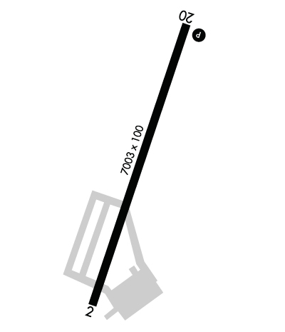
Lat: N 3752.1     Long: W 08951.7     Elev: 371     Var: -00  Longest Runway: 7000
  
    CTAF: 122.8

FBO info for KK02:      
CAPE AIR CHARTER Ph: 573-543-5100 Fax: 573-543-5500 Freq: 122.8


FBO's at nearby airports who want your business:

 Runway & Approach Info
  Rwy  
    Length    
  Land Dist Avail  
  Approach*  
    Rwy  
Length
  Land Dist Avail  
 Approach* 
02
7000x100  6480'          
 
  
20
  7000x100  7000'          
 
 * only ILS, LOC, LDA, and SDF approaches to a specific runway are shown

Runway Weight Capability   (lbs.)
Runway IDSingle WheelDouble WheelDouble Tandem WheelDual Double Wheel
02/2028,00048,000N/AN/A


Database effective date: 06/05/2008

Facility Name: PERRYVILLE MUNI
City Name: PERRYVILLE
County: PERRY
State abbrev: MO
State Name: MISSOURI
   
Ownership: PUBLICLY OWNED
Use: OPEN TO THE PUBLIC
Owner's Name: CITY OF PERRYVILLE
Address: 120 N JACKSON
 PERRYVILLE, MO 63775
Owner's Phone: 573-547-2594
  
Manager's Name: CHARLES LAROSE; PUBLIC WORKS DIRECTOR
Address: 120 NORTH JACKSON
 PERRYVILLE, MO 63775
Phone: 573-547-2594
   
FAA Region: CENTRAL
FAA Field Office: NONE

Click here to submit your photo
Area Map of K02
Click Here for Rand McNally Map of K02

Sunrise / Sunset times for:
PERRYVILLE MUNI
Date: Sunrise Sunset
May 01, 2008 6:0319:51
June 01, 2008 5:3920:16
July 01, 2008 5:4120:25
August 01, 2008 6:0320:08
September 01, 2008 6:3019:28
October 01, 2008 6:5618:41
November 01, 2008 7:2618:00
December 01, 2008 6:5716:40
January 01, 2009 7:1516:51
February 01, 2009 7:0417:23
March 01, 2009 6:3117:53
April 01, 2009 6:4519:22

 Airport Facilities
Airport Attendance Schedule: MON-FRI 0800-1630, SAT-SUN 0800-1400; FOR SERVICE AFTER HRS CALL (573) 543-2570.
Airport Status: OPERATIONAL (This Status can change at any time - please check NOTAMS)
Airport Lighting Schedule: DUSK-DAWN; ACTVT MIRL RY 02/20, PAPI RY 20, REIL RYS 02 & 20 - CTAF.
Airport Storage Available: Tie Downs, Hanger
Extra Services Available: NONECharter, Flight Instruction, Aircraft Rental
Wind Indicator: YES - (lighted)
Control Tower: NO
CTAF Frequency: 122.800
Unicom Frequency: 122.800
Rotating Beacon Color: CLEAR-GREEN (Light Land Airport)
Segmented Circle: YES
Landing Fee: NO

Airport Services
Type of Fuel Available: Grade 100LL, JET A (freeze point -40C); FOR FUEL AFT HRS CALL NR POSTED ON TERMINAL.
Airframe Repair Service: MINOR
Power Plant Repair Service: MINOR

Geographic Data
Latitude: N3752.1   Longitude: W08951.7  (ESTIMATED)
Arpt Elevation: 371ft (SURVEYED)
Magnetic Variation: 00E
9 miles N of PERRYVILLE
Traffic Pattern Altitude:
Sectional Chart: ST LOUIS

  Aircraft Data
Operations (reported)
YearlyAvg. Daily
General Aviation transient: 370010
General Aviation Local: 14004
Air Taxi: 3001
Commercial: 00
Commuter: 00
Military: 5001
Aircraft based on Field
General Aviation Singles: 7
General Aviation Multi: 1
Jet Aircraft: 1
General Aviation Helicopters: 0
Military Aircraft: 0
Gliders: 0
Ultralights: 0

  FAA Services
FSS on field: NO
FSS tie-in: SAINT LOUIS
FSS Phone: 1-800-WX-BRIEF
Who issues Notams: STL
Notam D service at airport: YES
ARTCC Name: KANSAS CITY
 
  Federal Status
Airport Certification:
Aircraft Rescue & Firefighting Index: None
Airport of Entry: No
Custom Landing Rights: No
Joint Civil/Military: No
Military Landing rights: YES

Runway Identification: 02/20
Length: 7000 ft
Width: 100 ft
Surface: CONCRETE-FAIR CONDITION
Edge lights: Medium Intensity


Runway: 02
 
Runway: 20
Mag heading:  17ºMag heading:  197º
Rwy Slope:  .04% UpRwy Slope:  -.04% Down
Approach:  Approach:  
Pattern:  Left TrafficPattern:  Left Traffic
Markings:  NONSTANDARDMarkings:  NONPRECISION INSTRUMENT
Marking Condition:  FAIR; RWY 02 NSTD NPI MARKINGS; AIMING POINT MKGS 500 FT NORTH OF DSPLD THLD FOR RY 02.Marking Condition:  GOOD; RWY 20; MARKINGS FADED.
Arresting Dev:  Arresting Dev:  
Lat & Long:  N3751.6  W08951.9Lat. & Long.:  N3752.7  W08951.5
Elev:  368.0 ft. MSLElev:  371.0 ft. MSL
TCH:  TCH:  
Visual Glide Path:  Visual Glide Path:  
Displaced Threshold:  520 feetDisplaced Threshold:  No
Touchdown Zone:  NOTouchdown Zone:  NO
Touchdown Elev.:  Touchdown Elev.:  
Visual Glide Slope:  Visual Glide Slope:  2-Light PAPI on LEFT side of Runway
RVR Equipment:  RVR Equipment:  
RVV Equipment:  NORVV Equipment:  NO
Approach Lights:  Approach Lights:  
REIL:  YES; REIL LOCATED AT RY THLD; NOT AT DSPLCD THLD.REIL:  YES
Centerline Lights:  NOCenterline Lights:  NO
Touchdown lights:  NOTouchdown lights:  NO
Runway Catagory:  OTHER THAN UTILITY RUNWAY WITH A NON PRECISION APPROACH HAVING VISIBILITY MINIMUNS GREATHER THAN 3/4 MILERunway Catagory:  OTHER THAN UTILITY RUNWAY WITH A NON PRECISION APPROACH HAVING VISIBILITY MINIMUNS GREATHER THAN 3/4 MILE
Obstructions:  ROADObstructions:  
Marked:  NOT Marked/LightedMarked:  
Clearance slope:  20:1; 50:1 TO DSPLCD THLD.Clearance slope:  50:1
Obstruction height:  16 feet AGLObstruction height:  
Dist. from runway:  525 feetDist. from runway:  
Centerline offset:  0BCenterline offset:  
Comments:  +1-2 FT GND; 0-100 FT FM RY END 115-250 R.Comments:  

Remarks
  • THIS AIRPORT HAS BEEN SURVEYED BY THE NATIONAL GEODETIC SURVEY.
  • HIGH PERFORMANCE MILITARY JET ACFT PRODUCTION TEST FLYING DURING DALGT HRS; CABLES MAY BE ACROSS RY AT THESE TIMES. CABLES ARE LCTD APRXLY 1,800 FT SOUTH OF RY 20 THLD & 1,800 FT NORTH OF RY 02 THLD. CHECK NOTAMS & ASK UNICOM OPR FOR CURRENT RY SITUATION.
  • TRANSIENT ACFT USE FACILITES ON W SIDE OF RY.
  • NTSD RY SAFETY AREA BYD RY 20 END; INCORRECT TERRAIN GRADES AND CROPS.

  • Federal Agreements
  • NATIONAL PLAN OF INTEGRATED AIRPORT SYSTEMS (NPIAS)
  • GRANT AGREEMENTS UNDER FAAP/ADAP/AIP
  • SURPLUS PROPERTY AGREEMENT UNDER REGULATION 16-WAA
  • ASSURANCES PURSUANT TO TITLE VI, CIVIL RIGHTS ACT OF 1964

  • Airport Inspection Data
    Airport Inspected:: STATE - performed by STATE AERONAUTICAL PERSONNEL
    Inspection Date: 11/09/2005


    Airport Communications & Frequencies:
    CTAF Frequency: 122.800
    Unicom Frequency: 122.800

    Remarks
  • APCH/DEP SVC PROVIDED BY KANSAS CITY ARTCC ON FREQS 127.47/291.7 (FARMINGTON RCAG).