
| PICKENS COUNTY JASPER GA |
| |
| Lat: N 3427.2 Long: W 08427.4 Elev: 1535 Var: +04 Longest Runway: 5000 | ||
| AWOS: 118.55 CTAF: 122.72 | ||
| ||||||||||||||||||||||||||||||||||||||||||||||||||||||||||||||||||||
| ||||||||||||||||||||||||||||||||||||||||||||||||||||||||||||||||||||
| ||||||||||||||||||||||||||||||||||||||||||||||||||||||||||||||||||||
| Rwy | Rwy | |||||||
| 5000x100 | 5000' | 5000x100 | 5000' | |||||
| Runway ID | Single Wheel | Double Wheel | Double Tandem Wheel | Dual Double Wheel |
| 16/34 | 60,500 | 95,000 | N/A | N/A |
| These numbers are Advisory and are not limits. The Airport Manager should have more accurate Weight Limits | ||||
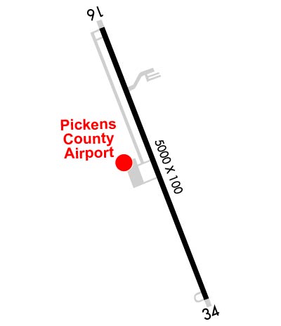 Airport Diagram might not be current. | |
| Facility Name: | PICKENS COUNTY |
| City Name: | JASPER |
| County: | PICKENS |
| State abbrev: | GA |
| State Name: | GEORGIA |
| Ownership: | PUBLICLY OWNED |
| Use: | OPEN TO THE PUBLIC |
| Owner's Name: | PICKENS COUNTY |
| Address: | 1266 EAST CHURCH STREET, SUITE 201 |
| JASPER, GA 30143 | |
| Owner's Phone: | 706-253-8817 |
| Manager's Name: | RANDY THOMASON |
| Address: | 193 AIRPORT ROAD |
| JASPER, GA 30143 | |
| Phone: | (770) 893-8135 |
| FAA Region: | SOUTHERN |
| FAA Field Office: | ATL |

| Date | Sunrise | Sunset |
|---|---|---|
| 09/24/21 Friday | 7:27 | 19:32 |
| 09/25/21 Saturday | 7:28 | 19:31 |
| 09/26/21 Sunday | 7:29 | 19:29 |
| 09/27/21 Monday | 7:29 | 19:28 |
| 09/28/21 Tuesday | 7:30 | 19:26 |
| 09/29/21 Wednesday | 7:31 | 19:25 |
| 09/30/21 Thursday | 7:31 | 19:24 |
| 10/01/21 Friday | 7:32 | 19:22 |
| 10/02/21 Saturday | 7:33 | 19:21 |
| 10/03/21 Sunday | 7:34 | 19:20 |
| 10/04/21 Monday | 7:34 | 19:18 |
| 10/05/21 Tuesday | 7:35 | 19:17 |
| 10/06/21 Wednesday | 7:36 | 19:15 |
| 10/07/21 Thursday | 7:37 | 19:14 |
| Airport Attendance Schedule | 7 Days A Week 0900-1800 |
| Airport Status | OPERATIONAL (This Status can change at any time - please check NOTAMS) |
| Airport Lighting Schedule | SS-SR |
| Airport Storage Available | Tie Downs |
| Extra Services Available | Flight Instruction, Aircraft Rental |
| Wind Indicator | YES - (lighted) |
| Control Tower | NO |
| CTAF Frequency | 122.725 |
| Unicom Frequency | 122.725 |
| Rotating Beacon Color | CLEAR-GREEN (Light Land Airport) |
| Segmented Circle | YES |
| Landing Fee | NO |
| Airport Inspected | STATE - performed by STATE AERONAUTICAL PERSONNEL |
| Inspection Date | 05/21/2021 |
| Type of Fuel Available | Grade 100LL, JET A |
| Airframe Repair Service | MAJOR |
| Power Plant Repair Service | MINOR |
| Latitude | N3427.2 |
| Longitude | W08427.4 (ESTIMATED) |
| Arpt Elevation | 1535ft (SURVEYED) |
| Magnetic Variation | 04W |
| 2 miles SW | of JASPER |
| Traffic Pattern Altitude | |
| Sectional Chart | ATLANTA |
| Operations (Reported) | Yearly | Avg. Daily |
|---|---|---|
| General Aviation Transient | 19500 | 53 |
| General Aviation Local | 22000 | 60 |
| Air Taxi | 0 | 0 |
| Commerical | 0 | 0 |
| Commuter | 0 | 0 |
| Military | 1500 | 4 |
| Aircraft based on Field | |
|---|---|
| General Aviation Singles | 72 |
| General Aviation Multi | 3 |
| Jet Aircraft | 0 |
| General Aviation Helicopters | 2 |
| Military Aircraft | 0 |
| Gliders | 0 |
| Ultralights | 0 |
| FSS on field | NO |
| FSS tie-in | MACON |
| FSS Phone | 1-800-WX-BRIEF |
| Who issues Notams | MCN |
| Notam D service at airport | YES |
| ARTCC Name | ATLANTA |
| Airport Certification | |
| Aircraft Rescue & Firefighting Index | None |
| Airport of Entry | No |
| Custom Landing Rights | No |
| Joint Civil/Military | No |
| Military Landing rights | YES |
| NATIONAL PLAN OF INTEGRATED AIRPORT SYSTEMS (NPIAS) |
| GRANT AGREEMENTS UNDER FAAP/ADAP/AIP |
| ASSURANCES PURSUANT TO TITLE VI, CIVIL RIGHTS ACT OF 1964 |
| EXTENSIVE STUDENT TRNG ATL340045-ATL355049; 3000-9000 FT; 1200-1730. |
| DEER & WILDLIFE ON & INVOF ARPT. |
| FOR CD CTC ATLANTA ARTCC AT 770-210-7692. |
Airport Communications & Frequencies:
| |||||||||
| Runway: 16 | Runway: 34 | ||
| Mag heading: | 163° | Mag heading: | 343° |
| Rwy Slope: | .69% Up | Rwy Slope: | -.69% Down |
| Approach: | Approach: | ||
| Pattern: | Left Traffic | Pattern: | Left Traffic |
| Markings: | NONPRECISION INSTRUMENT | Markings: | NONPRECISION INSTRUMENT |
| Marking Condition: | FAIR | Marking Condition: | FAIR |
| Arresting Dev: | Arresting Dev: | ||
| Lat & Long: | N3427.6 W08427.6 | Lat. & Long.: | N3426.8 W08427.3 |
| Elev: | 1500.5 ft. MSL | Elev: | 1535.1 ft. MSL |
| TCH: | 30 ft. AGL | TCH: | 27 ft. AGL |
| Visual Glide Path: | 3.00 degrees | Visual Glide Path: | 3.00 degrees |
| Displaced Threshold: | No | Displaced Threshold: | No |
| Touchdown Zone: | YES | Touchdown Zone: | YES |
| Touchdown Elev.: | 1515.4 feet | Touchdown Elev.: | 1535.1 feet |
| Visual Glide Slope: | 2-Light PAPI on RIGHT side of Runway | Visual Glide Slope: | 2-Light PAPI on LEFT side of Runway |
| RVR Equipment: | RVR Equipment: | ||
| RVV Equipment: | NO | RVV Equipment: | NO |
| Approach Lights: | Approach Lights: | ||
| REIL: | NO | REIL: | NO |
| Centerline Lights: | NO | Centerline Lights: | NO |
| Touchdown lights: | NO | Touchdown lights: | NO |
| Runway Category: | Runway with a Non-precision Approach having visibility minimums greater than 3/4 mile | Runway Category: | Runway with a Non-precision Approach having visibility minimums greater than 3/4 mile |
| Declared Distances: | Declared Distances: |
Thanks for using FltPlan.com
all rights reserved © 1999-2021 by Flight Plan LLC


